Tongren
Prefecture-level city in Guizhou, People's Republic of China
Tongren 铜仁市 Tungjen | |
|---|---|
Prefecture-level city | |
 | |
 Location of Tongren City jurisdiction in Guizhou | |
| Coordinates (Tongren municipal government): 27°43′54″N 109°11′22″E / 27.7316°N 109.1895°E / 27.7316; 109.1895 | |
| Country | People's Republic of China |
| Province | Guizhou |
| Area | |
| • Total | 18,014 km2 (6,955 sq mi) |
| Population (2020) | |
| • Total | 3,298,468 |
| GDP[1] | |
| • Total | CN¥ 132.8 billion US$ 19.3 billion |
| • Per capita | CN¥ 40,269 US$ 5,838 |
| Time zone | UTC+8 (China Standard) |
| Area code | 856 |
| ISO 3166 code | CN-GZ-06 |
| Website | www |
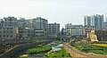
Tongren (simplified Chinese: 铜仁; traditional Chinese: 銅仁; pinyin: Tóngrén) is a prefecture-level city in eastern Guizhou province, People's Republic of China, located within a tobacco planting and crop agricultural area. Tongren was known as Tongren Prefecture (铜仁地区) until November 2011, when it was converted into a prefecture-level city.[2]
History
During the Yongle period (1403–1424) of the Ming dynasty (1368–1644), two local governments known as "Sizhou Xuanweisi" (思州宣慰司)and "Sinan Xuanweisi" (思南宣慰司) resisted full subjugation. Yongle Emperor sent troops to pacify the rebellion and set up a provincial administrative region known as "Guizhou Buzhengshisi" (贵州布政使司).[3] Since then, their administrators were appointed by the central government.[3]
Administrative divisions
Tongren comprises 2 districts, 4 counties, and 4 autonomous counties.
- Districts:
- Bijiang District (碧江区)
- Wanshan District (万山区)
- Counties:
- Dejiang County (德江县)
- Jiangkou County (江口县)
- Sinan County (思南县)
- Shiqian County (石阡县)
- Autonomous counties:
- Yuping Dong Autonomous County (玉屏侗族自治县)
- Songtao Miao Autonomous County (松桃苗族自治县)
- Yinjiang Tujia and Miao Autonomous County (印江土家族苗族自治县)
- Yanhe Tujia Autonomous County (沿河土家族自治县)
| Map |
|---|
 Bijiang Wanshan Jiangkou County Yuping County Shiqian County Sinan County Yinjiang County Dejiang County Yanhe County Songtao County |

Climate
| Climate data for Tongren, elevation 353 m (1,158 ft), (1991–2020 normals, extremes 1981–2010) | |||||||||||||
|---|---|---|---|---|---|---|---|---|---|---|---|---|---|
| Month | Jan | Feb | Mar | Apr | May | Jun | Jul | Aug | Sep | Oct | Nov | Dec | Year |
| Record high °C (°F) | 25.2 (77.4) | 32.0 (89.6) | 36.5 (97.7) | 35.4 (95.7) | 37.3 (99.1) | 38.3 (100.9) | 40.5 (104.9) | 39.5 (103.1) | 39.7 (103.5) | 36.7 (98.1) | 32.6 (90.7) | 23.9 (75.0) | 40.5 (104.9) |
| Mean daily maximum °C (°F) | 9.1 (48.4) | 12.0 (53.6) | 16.7 (62.1) | 22.9 (73.2) | 27.0 (80.6) | 29.8 (85.6) | 32.9 (91.2) | 32.9 (91.2) | 28.9 (84.0) | 22.8 (73.0) | 17.6 (63.7) | 11.9 (53.4) | 22.0 (71.7) |
| Daily mean °C (°F) | 5.8 (42.4) | 8.0 (46.4) | 12.1 (53.8) | 17.7 (63.9) | 21.8 (71.2) | 25.2 (77.4) | 27.9 (82.2) | 27.5 (81.5) | 23.7 (74.7) | 18.2 (64.8) | 13.1 (55.6) | 8.0 (46.4) | 17.4 (63.4) |
| Mean daily minimum °C (°F) | 3.5 (38.3) | 5.4 (41.7) | 9.0 (48.2) | 14.1 (57.4) | 18.2 (64.8) | 21.9 (71.4) | 24.2 (75.6) | 23.8 (74.8) | 20.2 (68.4) | 15.2 (59.4) | 10.2 (50.4) | 5.4 (41.7) | 14.3 (57.7) |
| Record low °C (°F) | −3.6 (25.5) | −3.7 (25.3) | −2.0 (28.4) | 4.2 (39.6) | 8.5 (47.3) | 14.2 (57.6) | 16.7 (62.1) | 17.1 (62.8) | 12.8 (55.0) | 5.0 (41.0) | −0.4 (31.3) | −3.0 (26.6) | −3.7 (25.3) |
| Average precipitation mm (inches) | 41.2 (1.62) | 46.3 (1.82) | 73.8 (2.91) | 122.6 (4.83) | 188.1 (7.41) | 222.4 (8.76) | 209.8 (8.26) | 129.5 (5.10) | 83.7 (3.30) | 86.7 (3.41) | 56.3 (2.22) | 31.8 (1.25) | 1,292.2 (50.89) |
| Average precipitation days (≥ 0.1 mm) | 12.0 | 12.5 | 15.6 | 16.5 | 16.9 | 15.5 | 12.3 | 11.0 | 9.1 | 12.0 | 9.9 | 10.0 | 153.3 |
| Average snowy days | 3.9 | 2.4 | 0.8 | 0 | 0 | 0 | 0 | 0 | 0 | 0 | 0 | 1.5 | 8.6 |
| Average relative humidity (%) | 75 | 75 | 76 | 77 | 78 | 81 | 77 | 75 | 76 | 78 | 77 | 74 | 77 |
| Mean monthly sunshine hours | 34.1 | 40.8 | 59.6 | 81.1 | 96.7 | 93.2 | 164.1 | 176.6 | 113.3 | 80.8 | 64.0 | 52.0 | 1,056.3 |
| Percent possible sunshine | 10 | 13 | 16 | 21 | 23 | 23 | 39 | 44 | 31 | 23 | 20 | 16 | 23 |
| Source: China Meteorological Administration[4][5] | |||||||||||||
Economy
In July 2018, the Tongren Transportation & Tourism Investment Group announced a joint venture with Hyperloop Transportation Technologies to construct a Hyperloop track in Tongren, along with an industrial research park.[6]
The city is served by Tongren Fenghuang Airport.
Education
References
- ^ 贵州统计年鉴(2021). 中国统计出版社. ISBN 9787503795558.
- ^ 国务院批复同意撤销铜仁地区设立地级铜仁市 (in Chinese). 7 November 2011. Archived from the original on 5 December 2011. Retrieved 2011-11-25.
- ^ a b “改土归流”的起源与结果. 163.com (in Chinese). 12 March 2020. Retrieved 28 August 2020.
- ^ 中国气象数据网 – WeatherBk Data (in Simplified Chinese). China Meteorological Administration. Retrieved 28 April 2023.
- ^ 中国气象数据网 (in Simplified Chinese). China Meteorological Administration. Retrieved 28 April 2023.
- ^ Zhao, Runhua (Jul 19, 2018). "Hyperloop Transportation Technologies to build Hyperloop in Southwest China with local partner". TechNode. Retrieved 20 July 2018.

Largest cities in Guizhou Source: China Urban Construction Statistical Yearbook 2018 Urban Population and Urban Temporary Population | ||||||||||||||||||||||||||||||||||||||||||||||||||||||||
|---|---|---|---|---|---|---|---|---|---|---|---|---|---|---|---|---|---|---|---|---|---|---|---|---|---|---|---|---|---|---|---|---|---|---|---|---|---|---|---|---|---|---|---|---|---|---|---|---|---|---|---|---|---|---|---|---|
| ||||||||||||||||||||||||||||||||||||||||||||||||||||||||


Authority control databases | |
|---|---|
| International |
|
| National |
|
 | This Guizhou location article is a stub. You can help Wikipedia by expanding it. |
- v
- t
- e


