Qingyang, Gansu
City in Gansu, China
Prefecture-level city in Gansu, People's Republic of China
Qingyang 庆阳市 | |
|---|---|
Prefecture-level city | |
 | |
 Location of Qingyang Prefecture within Gansu | |
| Coordinates (Qingyang municipal government): 35°42′33″N 107°38′37″E / 35.7091°N 107.6436°E / 35.7091; 107.6436 | |
| Country | People's Republic of China |
| Province | Gansu |
| County-level divisions | 1 district 7 counties |
| Township-level divisions | 3 subdistricts 36 towns 79 townships 1 ethnic township |
| Village-level divisions | 74 residential communities 1,254 villages |
| Municipal seat | Xifeng District |
| Area | |
| • Prefecture-level city | 27,119 km2 (10,471 sq mi) |
| Population (2022)[1] | |
| • Prefecture-level city | 2,158,400 |
| • Urban | 949,200 |
| • Rural | 1,209,200 |
| GDP[2] | |
| • Prefecture-level city | CN¥ 60.9 billion US$ 9.8 billion |
| • Per capita | CN¥ 27,366 US$ 4,394 |
| Time zone | UTC+8 (China Standard) |
| Postal code | 745100 |
| Area code | 0934 |
| ISO 3166 code | CN-GS-10 |
| Licence plate prefixes | 甘M |
| Administrative division code | 621000 |
| Website | www |
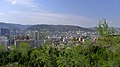
Qingyang (simplified Chinese: 庆阳; traditional Chinese: 慶陽; pinyin: Qìngyáng) is a prefecture-level city in eastern Gansu province, China.
Geography and climate
Qingyang is the easternmost prefecture-level division of Gansu and is thus sometimes referred to as "Longdong" (陇东). It forms an administrative peninsula, as it is surrounded, on all sides but the south, by Shaanxi and Ningxia. It is in the lower middle part of the Yellow River on the loess plateau and is within the eastern Gansu basin. Elevation ranges from 885 to 2082 meters above sea-level. There are 5 major rivers in Qingyang including the Malian (马莲河), Pu (蒲河), Hong (洪河), Xilang (四郎河), and Hulu or "Gourd" (葫芦河). Their combined annual flow is more than 800 million cubic meters. Bordering prefecture-level cities are:
Gansu:
- Pingliang – south/southwest
Qingyang has a humid continental climate (Köppen Dwb) with monsoonal influences. The normal monthly mean temperature ranges from −4.2 °C (24.4 °F) in January to 21.4 °C (70.5 °F) in July, with the annual mean standing at 9.20 °C (48.6 °F). The normal annual precipitation is 528 mm (20.8 in), with a two/thirds of it occurring from June to September, and winter seeing minimal precipitation.
Average temperatures for most of Qingyang's administrative area range between 7 and 10 °C. Annual precipitation is 480 to 660 mm and there are between 140~180 frost free days.[citation needed]
The area is 27,119 km2 (10,471 sq mi) with 200 km2 (77 sq mi) of forest and 530 km2 (200 sq mi) of grassland.[citation needed]
| Climate data for Qingyang (Xifeng District, 1991–2020 normals, extremes 1981–2010) | |||||||||||||
|---|---|---|---|---|---|---|---|---|---|---|---|---|---|
| Month | Jan | Feb | Mar | Apr | May | Jun | Jul | Aug | Sep | Oct | Nov | Dec | Year |
| Record high °C (°F) | 13.1 (55.6) | 19.5 (67.1) | 26.4 (79.5) | 31.6 (88.9) | 31.9 (89.4) | 35.9 (96.6) | 36.4 (97.5) | 32.9 (91.2) | 33.6 (92.5) | 26.5 (79.7) | 20.1 (68.2) | 15.2 (59.4) | 36.4 (97.5) |
| Mean daily maximum °C (°F) | 0.8 (33.4) | 4.6 (40.3) | 10.6 (51.1) | 17.4 (63.3) | 21.7 (71.1) | 25.7 (78.3) | 26.9 (80.4) | 25.0 (77.0) | 20.1 (68.2) | 14.3 (57.7) | 8.4 (47.1) | 2.5 (36.5) | 14.8 (58.7) |
| Daily mean °C (°F) | −3.8 (25.2) | −0.4 (31.3) | 5.2 (41.4) | 11.6 (52.9) | 16.1 (61.0) | 20.3 (68.5) | 21.9 (71.4) | 20.3 (68.5) | 15.5 (59.9) | 9.6 (49.3) | 3.5 (38.3) | −2.2 (28.0) | 9.8 (49.6) |
| Mean daily minimum °C (°F) | −7.4 (18.7) | −4.1 (24.6) | 1.0 (33.8) | 6.7 (44.1) | 11.2 (52.2) | 15.5 (59.9) | 17.8 (64.0) | 16.6 (61.9) | 12.1 (53.8) | 6.1 (43.0) | −0.2 (31.6) | −5.8 (21.6) | 5.8 (42.4) |
| Record low °C (°F) | −18.6 (−1.5) | −15.6 (3.9) | −12.6 (9.3) | −5.2 (22.6) | −0.6 (30.9) | 7.2 (45.0) | 10.5 (50.9) | 6.5 (43.7) | 2.6 (36.7) | −6.9 (19.6) | −15.5 (4.1) | −21.4 (−6.5) | −21.4 (−6.5) |
| Average precipitation mm (inches) | 5.8 (0.23) | 8.9 (0.35) | 17.6 (0.69) | 32.8 (1.29) | 46.2 (1.82) | 69.2 (2.72) | 110.5 (4.35) | 104.9 (4.13) | 84.1 (3.31) | 44.0 (1.73) | 14.7 (0.58) | 3.5 (0.14) | 542.2 (21.34) |
| Average precipitation days (≥ 0.1 mm) | 4.3 | 5.2 | 6.5 | 6.8 | 8.7 | 10.1 | 11.9 | 12.1 | 11.4 | 9.3 | 5.4 | 3.0 | 94.7 |
| Average snowy days | 6.7 | 7.7 | 5.4 | 1.1 | 0 | 0 | 0 | 0 | 0 | 0.9 | 4.1 | 4.9 | 30.8 |
| Average relative humidity (%) | 52 | 54 | 52 | 50 | 53 | 58 | 69 | 74 | 75 | 70 | 60 | 52 | 60 |
| Mean monthly sunshine hours | 187.8 | 174.7 | 202.5 | 228.4 | 247.0 | 239.1 | 228.8 | 205.9 | 161.3 | 172.4 | 182.0 | 194.4 | 2,424.3 |
| Percent possible sunshine | 60 | 56 | 54 | 58 | 57 | 55 | 52 | 50 | 44 | 50 | 60 | 65 | 55 |
| Source: China Meteorological Administration[3][4] | |||||||||||||
History
Qingyang was part of the area where the earliest cultures along the Yellow River developed and was part of the heartland of the Qin state that would eventually unite China. It was also an important place in the Chinese Communist Revolution.
Meteor shower
In March or April 1490 AD a presumed meteor shower occurred in the Qingyang district.[5][6] If a meteor shower did occur, it may have been the result of the breakup of an asteroid. At least three surviving Chinese historical records describe a shower during which "stones fell like rain", killing more than 10,000 people.[5][7] Due to the paucity of detailed information and the lack of surviving meteorites or other physical evidence, researchers have also been unable to definitively state the exact nature of the dramatic event.[8]
Administration
Qingyang has 1 urban district, 7 counties, and 146 towns with a total population of 2,158,400, of which 949,200 live in urban areas.[1]
| Map | ||||||
|---|---|---|---|---|---|---|
 Xifeng Qingcheng County Huan County Huachi County Heshui County Zhengning County Ning County Zhenyuan County | ||||||
| # | Name | Hanzi | Hanyu Pinyin | Population (2022 est.)[9] | Area (km²) | Density (/km²) |
| 1 | Xifeng District | 西峰区 | Xīfēng Qū | 513,900 | 996 | 331 |
| 2 | Qingcheng County | 庆城县 | Qìngchéng Xiàn | 235,200 | 2,673 | 120 |
| 3 | Huan County | 环县 | Huán Xiàn | 301,700 | 9,236 | 37 |
| 4 | Huachi County | 华池县 | Huáchí Xiàn | 118,300 | 3,776 | 34 |
| 5 | Heshui County | 合水县 | Héshuǐ Xiàn | 134,700 | 2,976 | 57 |
| 6 | Zhengning County | 正宁县 | Zhèngníng Xiàn | 173,200 | 1,329 | 173 |
| 7 | Ning County | 宁县 | Níng Xiàn | 331,700 | 2,633 | 197 |
| 8 | Zhenyuan County | 镇原县 | Zhènyuán Xiàn | 510,000 | 3,500 | 146 |
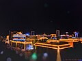
Economy
In 2022 Qingyang's GDP was 102.226 Billion RMB, 4.4% growth over the previous year. 12.2% of GDP was generated by the primary sector, 54.0% by the secondary sector and 33.8% by the tertiary sector. The per capita income was 22,878 RMB, for urban residents 37,585 RMB and for rural residents 12,276 RMB[1]
Petroleum and natural gas are the backbone of Qingyang's economy. Agricultural products include grains, donkeys, Huan County sheep, cattle, Jin jujubes, milk, apple, apricots and other fruits, vegetables, and berries. 69 different kinds of Chinese medicinal plants and herbs are collected or grown here, 25 of which are exported.
Transportation
- Qingyang Airport
- China National Highway 211
- China National Highway 309
- G22 Qingdao–Lanzhou Expressway
- Xi'an-Pingliang railway (limited service, station at Ning County)
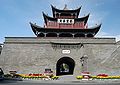
Culture
Qingyang is famous for its rich folk culture. Traditional Chinese art forms such as shadow puppet theater, paper cuts (such as the Qingyang sachet), folk music, and songs are still part of Qingyang's culture.
The local newspaper is called Longdong Daily (Chinese: 陇东报).[1]
References
- ^ a b c d "2022年庆阳市国民经济和社会发展统计公报". tjj.gansu.gov.cn. Retrieved 2024-01-19.
- ^ 甘肃省统计局、国家统计局甘肃调查总队 (November 2016). 《甘肃发展年鉴-2016》. 中国统计出版社. ISBN 978-7-5037-7894-0.
- ^ 中国气象数据网 – WeatherBk Data (in Simplified Chinese). China Meteorological Administration. Retrieved 27 August 2023.
- ^ 中国气象数据网 (in Simplified Chinese). China Meteorological Administration. Retrieved 27 August 2023.
- ^ a b Yau, K., Weissman, P., & Yeomans, D. Meteorite Falls In China And Some Related Human Casualty Events, Meteoritics, Vol. 29, No. 6, pp. 864-871, ISSN 0026-1114, bibliographic code: 1994Metic..29..864Y.
- ^ Webb, Sterling K., Juhl, Robert A. Meteorite deaths in Qingyang (Ch'ing-yang) in 1490, MeteoriteCentral.com website as archived on Mail-Archive.com, January 1, 2010. Retrieved March 13, 2013.
- ^ Gritzner, C. Human Casualties in Impact Events, WGN Journal of the International Meteor Organization, pp. 222-226, bib. code: 1997JIMO...25..222G.
- ^ Asteroid's close shave ranks among Earth's biggest hits (and misses), NBCNews.com website, February 14, 2013. Retrieved March 8, 2013.
- ^ "庆阳市各县市区人口数口排名2022年-红黑人口库". www.hongheiku.com. Retrieved 2024-01-19.
External links
- Official Website (Chinese)

Largest cities in Gansu Source: China Urban Construction Statistical Yearbook 2018 Urban Population and Urban Temporary Population | ||||||||||||||||||||||||||||||||||||||||||||||||||||||||||||||
|---|---|---|---|---|---|---|---|---|---|---|---|---|---|---|---|---|---|---|---|---|---|---|---|---|---|---|---|---|---|---|---|---|---|---|---|---|---|---|---|---|---|---|---|---|---|---|---|---|---|---|---|---|---|---|---|---|---|---|---|---|---|---|
| ||||||||||||||||||||||||||||||||||||||||||||||||||||||||||||||


| Authority control databases: National |
|
|---|


