Haixi Mongol and Tibetan Autonomous Prefecture
Autonomous prefecture in Qinghai, China
Haixi Prefecture 海西州 · 37°23′N 97°22′E / 37.38°N 97.37°E / 37.38; 97.37 | |
|---|---|
| Country | China |
| Province | Qinghai |
| Prefectural seat | Delingha |
| Area | |
| • Total | 325,785 km2 (125,786 sq mi) |
| Population (2017)[1] | |
| • Total | 515,200 |
| • Density | 1.6/km2 (4.1/sq mi) |
| • Major Ethnic Groups | Han−66.01% Hui−13.45% Tibetan−10.93% Mongolians−5.53% |
| GDP[2] | |
| • Total | CN¥ 50 billion US$ 7 billion |
| • Per capita | CN¥ 86,713 US$ 13,922 |
| Time zone | UTC+8 (China Standard) |
| Postal code | 817000 |
| Area code | 0977 |
| ISO 3166 code | CN-QH-28 |
| Website | www |
| Haixi Mongol and Tibetan Autonomous Prefecture | |||||||
|---|---|---|---|---|---|---|---|
| Chinese name | |||||||
| Chinese | 海西蒙古族藏族自治州 | ||||||
| |||||||
| Tibetan name | |||||||
| Tibetan | མཚོ་ནུབ་སོག་རིགས་ཆ་བོད་རིགས་རང་སྐྱོང་ཁུལ་ | ||||||
| |||||||
| Mongolian name | |||||||
| Mongolian Cyrillic | Хайши монгол ба Түвдийн өөртөө засах муж (Qayisi-yin Mongɣol Töbed ündüsüten-ü öbertegen zasaqu jvu) | ||||||
| Mongolian script | ᠬᠠᠶᠢᠰᠢ ᠶᠢᠨ ᠮᠣᠩᠭᠣᠯ ᠲᠥᠪᠡᠳ ᠦᠨᠳᠦᠰᠦᠲᠡᠨ ᠦ ᠥᠪᠡᠷᠲᠡᠭᠡᠨ ᠵᠠᠰᠠᠬᠤ ᠵᠧᠦ | ||||||
| |||||||
Haixi Mongolian and Tibetan Autonomous Prefecture (Chinese: 海西蒙古族藏族自治州; Mongolian: ᠬᠠᠶᠢᠰᠢ ᠶᠢᠨ ᠮᠣᠩᠭᠣᠯ ᠲᠥᠪᠡᠳ ᠦᠨᠳᠦᠰᠦᠲᠡᠨ ᠦ ᠥᠪᠡᠷᠲᠡᠭᠡᠨ ᠵᠠᠰᠠᠬᠤ ᠵᠧᠦ; Tibetan: མཚོ་ནུབ་སོག་རིགས་ཆ་བོད་རིགས་རང་སྐྱོང་ཁུལ་), locally also known as Qaidam Prefecture (Mongolian: ᠴᠠᠢᠳᠠᠮ; Tibetan: ཚྭ་འདམ་; Chinese: 柴达木), is an autonomous prefecture occupying much of the northern half of (as well as part of the southwest of) Qinghai Province, China. It has an area of 325,785 square kilometres (125,786 sq mi) and its seat is Delingha. The name of the prefecture literally means "west of (Qinghai) Lake."
Geladandong Mountain, the source of the Yangtze River, is located here.
History
After 1949, the People's Government of Dulan County was founded and the area was renamed Dulan Autonomous District (都兰自治区); in 1954, Dulan was renamed Haixi Mongol, Tibetan and Kazakh Autonomous District (海西蒙藏哈萨克族自治区) and in 1955, Haixi Mongol, Tibetan and Kazakh Autonomous Prefecture (海西蒙藏哈萨克族自治州). In 1963, it was renamed "海西蒙古族藏族哈萨克族自治州" (with the "Tibetan" added to the official county name). In 1985, after the Kazakhs had returned to Xinjiang, it was again renamed to Haixi Mongol and Tibetan Autonomous Prefecture.[3]
Demographics
As of the 2017 census, Haixi had 515,200 inhabitants.
The following is a composition of ethnic groups in the prefecture, taken in the 2010 Census.
| Nationality | Population | Percentage |
|---|---|---|
| Han | 322,996 | 66.01% |
| Tibetan | 53,498 | 10.93% |
| Hui | 65,828 | 13.45% |
| Mongolian | 27,043 | 5.53% |
| Tu/Monguor | 9,952 | 2.03% |
| Salar | 4,665 | 0.95% |
| Dongxiang | 2,734 | 0.56% |
| Manchu | 684 | 0.14% |
| Tujia | 346 | 0.07% |
| Kazakh | 525 | 0.11% |
| Others | 1066 | 0.22% |
Subdivisions
Haixi directly governs 3 county-level cities and 3 counties.
| Map | |||||||||
|---|---|---|---|---|---|---|---|---|---|
 Golmud (city) ※ Delingha (city) Mangnai (city) Ulan County Dulan County Tianjun County Da Qaidam ※ | |||||||||
| Name | Hanzi | Hanyu Pinyin | Mongolian (Transcription from Mongolian) | Tibetan | Wylie Tibetan Pinyin | Population (2010) | Area (km2) | Density (/km2) | |
| Delingha City (Delhi City) | 德令哈市 | Délìnghā Shì | ᠳᠡᠯᠡᠬᠡᠢ ᠬᠣᠲᠠ Delekei qota | གཏེར་ལེན་ཁ་གྲོང་ཁྱེར། | gter len kha grong khyer Dêrlênka Chongkyir | 91,855 | 61,613 | 1.49 | |
| Golmud City (Ge'ermu City) | 格尔木市 | Gé'ěrmù Shì | ᠭᠣᠯᠮᠣᠣᠠ ᠬᠣᠲᠠ Ɣool modu qota | ན་གོར་མོ་གྲོང་ཁྱེར། | na gor mo grong khyer Nakormo Chongkyir | 215,213 | 123,460 | 1.74 | |
| Mangnai City (Mangya City) | 茫崖市 | Mángyá Shì | ᠮᠠᠨᠭᠨᠠᠢ ᠶᠢᠨ ᠬᠣᠲᠠ Mangnai-yin qota | མང་ནེ་གྲོང་ཁྱེར། | mang ne grong khyer Mangnai Chongkyir | 33,451 | 49,000 | 0.63 | |
| Ulan County (Wulan County) | 乌兰县 | Wūlán Xiàn | ᠤᠯᠠᠭᠠᠨ ᠰᠢᠶᠠᠨ Ulaγan siyan | ཝུའུ་ལན་རྫོང་ | wu'u lan rdzong Wu'ulain Zong | 38,723 | 10,784 | 3.59 | |
| Dulan County | 都兰县 | Dūlán Xiàn | ᠳᠤᠯᠠᠭᠠᠨ ᠰᠢᠶᠠᠨ Dulaγan siyan | ཏུའུ་ལན་རྫོང་ | tu'u lan rdzong Tu'ulain Zong | 76,623 | 50,000 | 1.53 | |
| Tianjun County | 天峻县 | Tiānjùn Xiàn | ᠲᠢᠶᠡᠨ ᠵᠢᠶᠦ᠋ᠨ ᠰᠢᠶᠠᠨ Tiyen ǰiyün siyan | ཐེན་ཅུན་རྫོང་ | then cun rdzong Têncün Zong | 33,923 | 20,000 | 1.70 | |
| Da Qaidam Administrative Zone (Ih'qaidam Administrative Zone) | 大柴旦行政委员会 | Dàcháidàn Xíngzhèng Wěiyuánhuì | ᠶᠡᠬᠡ ᠴᠠᠢᠢᠳᠠᠮ ᠤᠨ ᠵᠠᠰᠠᠭ ᠵᠠᠬᠢᠷᠠᠭᠠᠨ ᠦ ᠵᠥᠪᠯᠡᠯ Yeke čayidam-un ǰasaγ ǰaqiraγan-ü ǰöblel | ཚྭ་འདམ་ཆེ་བའི་སྲིད་འཛིན་ཨུ་ཡོན་ལྷན་ཁང་། | tshwa 'dam che ba'i srid 'dzin u yon lhan khang | 13,671 | 34,000 | 0.40 | |
- The southwestern exclave of the Haixi Prefecture, separated from the rest of the prefecture by a "panhandle" of the Yushu Tibetan Autonomous Prefecture, is the Tanggula Town of Golmud City.
Gallery
-
 A picture taken in the southwestern part of the prefecture
 -
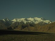 The Qingzang Railway can be seen on the far left


Notable features
- Delingha City
- Qaidam Basin
- Geladandong mountain
- Headwaters of the Yangtze River
- The Baigong Pipes
Notes
- ^ According to 2010 China National Census
- ^ 青海省统计局、国家统计局青海调查总队 (August 2016). 《青海统计年鉴-2016》. 中国统计出版社. ISBN 978-7-5037-7834-6. Archived from the original on 2017-12-28. Retrieved 2017-06-05.
- ^ 海西州. Qinghai Bureau of Civil Affairs (青海省民政厅网站). Archived from the original on 2007-09-28. Retrieved 2006-12-15..
For details, see: 海西蒙古族藏族自治州. XZQH.org.
Further reading
- A. Gruschke: The Cultural Monuments of Tibet’s Outer Provinces: Amdo - Volume 1. The Qinghai Part of Amdo, White Lotus Press, Bangkok 2001. ISBN 974-480-049-6
- Tsering Shakya: The Dragon in the Land of Snows. A History of Modern Tibet Since 1947, London 1999, ISBN 0-14-019615-3
External links
- Official website of Haixi Government Archived 2021-02-24 at the Wayback Machine
- v
- t
- e
cities
| Xining | |
|---|---|
| Haidong |
prefectures
| Haibei | |
|---|---|
| Huangnan | |
| Hainan | |
| Golog | |
| Yushu | |
| Haixi |
|
- 1 These are administrative zones, which are not standard units of local government, though they do function as such.

| |||||||||
|---|---|---|---|---|---|---|---|---|---|
| Regions |
|  | |||||||
| Prefectures and counties |
| ||||||||
| |||||||||
| |||||||||
|---|---|---|---|---|---|---|---|---|---|
| Regions |
|  | |||||||
| Prefectures and counties |
| ||||||||
| |||||||||


