Dali Bai Autonomous Prefecture
You can help expand this article with text translated from the corresponding article in Chinese. (May 2023) Click [show] for important translation instructions.
- Machine translation, like DeepL or Google Translate, is a useful starting point for translations, but translators must revise errors as necessary and confirm that the translation is accurate, rather than simply copy-pasting machine-translated text into the English Wikipedia.
- Do not translate text that appears unreliable or low-quality. If possible, verify the text with references provided in the foreign-language article.
- You must provide copyright attribution in the edit summary accompanying your translation by providing an interlanguage link to the source of your translation. A model attribution edit summary is
Content in this edit is translated from the existing Chinese Wikipedia article at [[:zh:大理白族自治州]]; see its history for attribution. - You may also add the template
{{Translated|zh|大理白族自治州}}to the talk page. - For more guidance, see Wikipedia:Translation.
Autonomous prefecture in Yunnan, China
Dali Prefecture 大理州 · Darl•lit Zox | |
|---|---|
Autonomous prefecture | |
 Three Pagodas  Dali Town  Downtown Dali  Yunnanyi  Panorama of Erhai | |
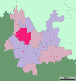 Location of Dali Prefecture in Yunnan | |
| Country | China |
| Province | Yunnan |
| Admin HQ | Dali |
| Government | |
| • Type | Autonomous prefecture |
| • CCP Secretary | Yang Guozong |
| • Congress Chairman | Zhang Jianping |
| • Governor | Yang Guozong |
| • CPPCC Chairman | Zhu Jianbin |
| Area | |
| • Total | 29,459 km2 (11,374 sq mi) |
| Population (2010)[1] | |
| • Total | 3,456,000 |
| • Density | 120/km2 (300/sq mi) |
| GDP[2] | |
| • Total | CN¥ 170 billion US$ 25.1 billion |
| • Per capita | CN¥ 51,302 US$ 7,567 |
| Postal code | 671000 |
| Area code | 0872 |
| ISO 3166 code | CN-YN-29 |
| Website | http://www.dali.gov.cn/ |
Dali Bai Autonomous Prefecture (Chinese: 大理白族自治州; pinyin: Dàlǐ Báizú Zìzhìzhōu; Bai: Darl•lit Baif•cuf zirl•zirl•zox) is an autonomous prefecture of northwestern Yunnan Province, People's Republic of China. Dali has an area of 29,460 square kilometres (11,370 sq mi) and its seat is located in Xiaguan, Dali City.
Subdivisions
The prefecture is subdivided into 12 county-level divisions: one county-level city, eight counties, and three autonomous counties:
| Map | ||||||
|---|---|---|---|---|---|---|
 Er Lake Dali (city) Yangbi County Xiangyun County Binchuan County Midu County Nanjian County Weishan County Yongping County Yunlong County Eryuan County Jianchuan County Heqing County | ||||||
| # | Name | Simplified Chinese | Hanyu Pinyin | Population (2010) | Area (km2) | Density (/km2) |
| 1 | Dali City | 大理市 | Dàlǐ Shì | 652,000 | 1,468 | 444 |
| 2 | Xiangyun County | 祥云县 | Xiángyún Xiàn | 456,000 | 2,498 | 183 |
| 3 | Binchuan County | 宾川县 | Bīnchuān Xiàn | 349,000 | 2,627 | 133 |
| 4 | Midu County | 弥渡县 | Mídù Xiàn | 313,000 | 1,571 | 199 |
| 5 | Yongping County | 永平县 | Yǒngpíng Xiàn | 175,000 | 2,884 | 61 |
| 6 | Yunlong County | 云龙县 | Yúnlóng Xiàn | 200,000 | 4,712 | 42 |
| 7 | Eryuan County | 洱源县 | Ěryuán Xiàn | 268,000 | 2,961 | 91 |
| 8 | Jianchuan County | 剑川县 | Jiànchuān Xiàn | 170,000 | 2,318 | 73 |
| 9 | Heqing County | 鹤庆县 | Hèqìng Xiàn | 255,000 | 2,395 | 106 |
| 10 | Yangbi Yi Autonomous County | 漾濞彝族自治县 | Yàngbì Yízú Zìzhìxiàn | 102,000 | 1,957 | 52 |
| 11 | Nanjian Yi Autonomous County | 南涧彝族自治县 | Nánjiàn Yízú Zìzhìxiàn | 212,000 | 1,802 | 118 |
| 12 | Weishan Yi and Hui Autonomous County | 巍山彝族回族自治县 | Wēishān Yízú Huízú Zìzhìxiàn | 304,000 | 2,266 | 134 |
Demography
Ethnic groups in Dali, 2000 census
| Ethnicity | Population | Percentage |
|---|---|---|
| Han | 1,659,730 | 50.35% |
| Bai | 1,081,167 | 32.8% |
| Yi | 426,634 | 12.94% |
| Hui | 66,085 | 2.0% |
| Lisu | 31,972 | 0.97% |
| Miao | 10,967 | 0.33% |
| Naxi | 4,302 | 0.13% |
| Achang | 3,330 | 0.1% |
| Others | 12,365 | 0.38% |
Local holidays
In addition to the national public holidays observed throughout China, Dali prefecture has local public holidays. Residents get three days off, from the 15th to the 17th day of the third month of the Chinese calendar, for the Third Month Fair (三月街), a traditional festival of the Bai people. Residents also get two days off, on November 22 and 23, for the Anniversary of the Establishment of the Autonomous Prefecture (自治州成立纪念日).[3]
References
- ^ According to 2010 China National Census Archived 2012-03-25 at the Wayback Machine
- ^ 云南省统计局、国家统计局云南调查总队 (December 2023). 《云南统计年鉴-2023》. 中国统计出版社. ISBN 978-7-5037-9653-1.
- ^ "大理州2023年放假通知来啦!三月街放假3天、州庆2天". www.sohu.com. Retrieved 19 March 2023.
External links
- Dali Prefecture Official Website
25°41′N 100°10′E / 25.69°N 100.16°E / 25.69; 100.16
- v
- t
- e
| Kunming | |
|---|---|
| Qujing | |
| Yuxi | |
| Baoshan | |
| Zhaotong | |
| Lijiang | |
| Pu'er | |
| Lincang |
| Chuxiong | |
|---|---|
| Honghe | |
| Wenshan | |
| Xishuangbanna | |
| Dali | |
| Dehong | |
| Nujiang | |
| Dêqên |

Authority control databases | |
|---|---|
| National |
|
| Geographic |
|
 | This Yunnan location article is a stub. You can help Wikipedia by expanding it. |
- v
- t
- e


