National Register of Historic Places listings in Wilson County, Kansas

This is a list of the National Register of Historic Places listings in Wilson County, Kansas. It is intended to be a complete list of the properties and districts on the National Register of Historic Places in Wilson County, Kansas, United States. The locations of National Register properties and districts for which the latitude and longitude coordinates are included below, may be seen in an online map.
There are 9 properties and districts listed on the National Register in the county.
This National Park Service list is complete through NPS recent listings posted June 14, 2024.[1]
Current listings
Map all coordinates using OpenStreetMap
Download coordinates as:
- KML
- GPX (all coordinates)
- GPX (primary coordinates)
- GPX (secondary coordinates)
| [2] | Name on the Register[3] | Image | Date listed[4] | Location | City or town | Description |
|---|---|---|---|---|---|---|
| 1 | Brown Hotel |  | July 21, 1995 (#95000863) | 523 Main St.; also 519-523 Main St. 37°25′03″N 95°40′50″W / 37.417500°N 95.680556°W / 37.417500; -95.680556 (Brown Hotel) | Neodesha | 519-523 Main represents a boundary increase of July 3, 2008 |
| 2 | Brush Creek Bridge |  | July 2, 1985 (#85001419) | ½ mile south of Coyville 37°40′41″N 95°53′48″W / 37.678056°N 95.896667°W / 37.678056; -95.896667 (Brush Creek Bridge) | Coyville | |
| 3 | Dorothy DeLay House | Upload image | December 20, 2023 (#100008863) | 124 North 2nd St. 37°25′06″N 95°40′34″W / 37.4184°N 95.6762°W / 37.4184; -95.6762 (Dorothy DeLay House) | Neodesha | |
| 4 | Dr. A.C. Flack House | Upload image | September 21, 1989 (#89001463) | 303 N. 8th St. 37°32′02″N 95°49′35″W / 37.533889°N 95.826389°W / 37.533889; -95.826389 (Dr. A.C. Flack House) | Fredonia | |
| 5 | Gold Dust Hotel |  | November 1, 1991 (#91001542) | 402 N. 7th St. 37°32′02″N 95°49′33″W / 37.533889°N 95.825833°W / 37.533889; -95.825833 (Gold Dust Hotel) | Fredonia | Built in 1884. |
| 6 | Neodesha City Hall Building | Upload image | March 26, 2018 (#100002248) | 102 S. 4th St. 37°25′02″N 95°40′43″W / 37.417277°N 95.678624°W / 37.417277; -95.678624 (Neodesha City Hall Building) | Neodesha | |
| 7 | Norman No. 1 Oil Well Site | 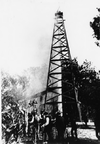 | August 28, 1974 (#74000846) | E. Mill St. 37°24′45″N 95°37′40″W / 37.412500°N 95.627778°W / 37.412500; -95.627778 (Norman No. 1 Oil Well Site) | Neodesha | |
| 8 | US Post Office-Fredonia | Upload image | October 17, 1989 (#89001638) | 428 Madison St. 37°32′05″N 95°49′53″W / 37.534722°N 95.831389°W / 37.534722; -95.831389 (US Post Office-Fredonia) | Fredonia | |
| 9 | US Post Office-Neodesha |  | October 17, 1989 (#89001647) | 123 N. 5th St. 37°25′00″N 95°40′53″W / 37.416667°N 95.681389°W / 37.416667; -95.681389 (US Post Office-Neodesha) | Neodesha |
See also
- List of National Historic Landmarks in Kansas
- National Register of Historic Places listings in Kansas
References
- ^ National Park Service, United States Department of the Interior, "National Register of Historic Places: Weekly List Actions", retrieved June 14, 2024.
- ^ Numbers represent an alphabetical ordering by significant words. Various colorings, defined here, differentiate National Historic Landmarks and historic districts from other NRHP buildings, structures, sites or objects.
- ^ "National Register Information System". National Register of Historic Places. National Park Service. July 9, 2010.
- ^ The eight-digit number below each date is the number assigned to each location in the National Register Information System database, which can be viewed by clicking the number.
External links
Wikimedia Commons has media related to National Register of Historic Places in Wilson County, Kansas.
- v
- t
- e

- Allen
- Anderson
- Atchison
- Barber
- Barton
- Bourbon
- Brown
- Butler
- Chase
- Chautauqua
- Cherokee
- Cheyenne
- Clark
- Clay
- Cloud
- Coffey
- Comanche
- Cowley
- Crawford
- Decatur
- Dickinson
- Doniphan
- Douglas
- Edwards
- Elk
- Ellis
- Ellsworth
- Finney
- Ford
- Franklin
- Geary
- Gove
- Graham
- Grant
- Gray
- Greeley
- Greenwood
- Hamilton
- Harper
- Harvey
- Haskell
- Hodgeman
- Jackson
- Jefferson
- Jewell
- Johnson
- Kearny
- Kingman
- Kiowa
- Labette
- Lane
- Leavenworth
- Lincoln
- Linn
- Logan
- Lyon
- Marion
- McPherson
- Meade
- Miami
- Mitchell
- Montgomery
- Morris
- Morton
- Nemaha
- Neosho
- Ness
- Norton
- Osage
- Osborne
- Ottawa
- Pawnee
- Phillips
- Pottawatomie
- Pratt
- Rawlins
- Reno
- Republic
- Rice
- Riley
- Rooks
- Rush
- Russell
- Saline
- Scott
- Sedgwick
- Seward
- Shawnee
- Sheridan
- Sherman
- Smith
- Stafford
- Stanton
- Stevens
- Sumner
- Thomas
- Trego
- Wabaunsee
- Wallace
- Washington
- Wichita
- Wilson
- Woodson
- Wyandotte
- Archaeological sites
- National Historic Landmarks
 Category
 NRHP portal


| |
|---|---|
| Topics | |
| Lists by state |
|
| Lists by insular areas | |
| Lists by associated state | |
| Other areas | |
| Related | |
| |

Municipalities and communities of Wilson County, Kansas, United States | ||
|---|---|---|
County seat: Fredonia | ||
| Cities |  | |
| Unincorporated communities | ||
| Townships | ||
| Footnotes | †This community is designated a Census-Designated Place (CDP) by the United States Census Bureau. | |
| ||


