National Register of Historic Places listings in Lincoln County, Kansas
This is a list of the National Register of Historic Places listings in Lincoln County, Kansas.
This is intended to be a complete list of the properties on the National Register of Historic Places in Lincoln County, Kansas, United States. The locations of National Register properties for which the latitude and longitude coordinates are included below, may be seen in a map.[1]
There are 16 properties listed on the National Register in the county.
This National Park Service list is complete through NPS recent listings posted June 7, 2024.[2]
Map all coordinates using OpenStreetMap
Download coordinates as:
- KML
- GPX (all coordinates)
- GPX (primary coordinates)
- GPX (secondary coordinates)
Current listings
| [3] | Name on the Register[4] | Image | Date listed[5] | Location | City or town | Description |
|---|---|---|---|---|---|---|
| 1 | Archeological Site Number 14LC306 | Upload image | July 9, 1982 (#82004882) | Address restricted | Lincoln | |
| 2 | Behrhorst Brothers Hardware | 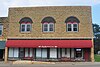 | October 17, 2022 (#100008289) | 105 North Main St. 39°00′40″N 98°23′36″W / 39.0112°N 98.3934°W / 39.0112; -98.3934 (Behrhorst Brothers Hardware) | Sylvan Grove | |
| 3 | Bullfoot Creek Bridge |  | July 2, 1985 (#85001421) | 4 miles south and 0.9 miles east of Vesper 38°58′25″N 98°15′39″W / 38.973611°N 98.260833°W / 38.973611; -98.260833 (Bullfoot Creek Bridge) | Vesper | |
| 4 | Cummins Block Building |  | March 24, 2000 (#00000268) | 161 E. Lincoln 39°02′24″N 98°08′47″W / 39.039999°N 98.146258°W / 39.039999; -98.146258 (Cummins Block Building) | Lincoln | |
| 5 | Danske Evangelist Lutheran Kirke |  | September 12, 1991 (#91001154) | Between Trail and Timber Creeks due east of Denmark 39°05′22″N 98°16′42″W / 39.089407°N 98.278351°W / 39.089407; -98.278351 (Danske Evangelist Lutheran Kirke) | Grant Township | Built c.1875-1880; bell tower and steeple added in 1901. |
| 6 | Evangelical Lutheran School | 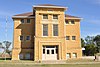 | October 2, 2015 (#15000690) | 308 N. Indiana St. 39°00′49″N 98°23′16″W / 39.0137°N 98.3879°W / 39.0137; -98.3879 (Evangelical Lutheran School) | Sylvan Grove | |
| 7 | Lincoln Carnegie Library |  | June 25, 1987 (#87000957) | 203 S. 3rd 39°02′21″N 98°08′41″W / 39.039167°N 98.144722°W / 39.039167; -98.144722 (Lincoln Carnegie Library) | Lincoln | |
| 8 | Lincoln City Park |  | March 26, 2020 (#100005124) | 500-700 blocks of East Lincoln Ave. 39°02′25″N 98°08′18″W / 39.0403°N 98.1384°W / 39.0403; -98.1384 (Lincoln City Park) | Lincoln | |
| 9 | Lincoln County Courthouse |  | July 13, 1976 (#76000825) | 3rd and Lincoln Ave. 39°02′27″N 98°08′41″W / 39.040833°N 98.144722°W / 39.040833; -98.144722 (Lincoln County Courthouse) | Lincoln | |
| 10 | Lincoln Downtown Historic District |  | June 1, 2020 (#100005123) | Roughly bounded by East and West Lincoln Ave., Elm St., Court St., West Court and South 5th St. 39°02′25″N 98°09′02″W / 39.0402°N 98.1505°W / 39.0402; -98.1505 (Lincoln Downtown Historic District) | Lincoln | |
| 11 | Lincoln High School |  | February 3, 2020 (#100004204) | 700 S. 4th St. 39°02′02″N 98°08′52″W / 39.0338°N 98.1477°W / 39.0338; -98.1477 (Lincoln High School) | Lincoln | |
| 12 | Marshall-Yohe House |  | April 19, 2001 (#01000386) | 316 S. 2nd St. 39°02′15″N 98°08′41″W / 39.037627°N 98.14472°W / 39.037627; -98.14472 (Marshall-Yohe House) | Lincoln | |
| 13 | Nielsen Farm | 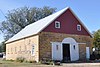 | January 11, 2006 (#05001513) | 1125 E. Pike Dr. 39°05′02″N 98°17′37″W / 39.083889°N 98.293611°W / 39.083889; -98.293611 (Nielsen Farm) | Sylvan Grove | |
| 14 | Salt Creek Truss Leg Bedstead Bridge | 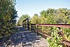 | May 9, 2003 (#03000368) | B Rd., 0.6 mile east of its intersection with 24th Rd., 1.0 mile north of Barnard 39°12′17″N 98°02′57″W / 39.204722°N 98.049167°W / 39.204722; -98.049167 (Salt Creek Truss Leg Bedstead Bridge) | Barnard | |
| 15 | Spring Creek Tributary Bridge | 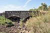 | July 2, 1985 (#85001440) | 8 miles south and 5 miles west of Lincoln 38°54′32″N 98°14′38″W / 38.908889°N 98.243889°W / 38.908889; -98.243889 (Spring Creek Tributary Bridge) | Lincoln | |
| 16 | Sylvan Grove Union Pacific Depot |  | April 2, 2014 (#14000118) | 131 S. Main St. 39°00′34″N 98°23′34″W / 39.009449°N 98.392871°W / 39.009449; -98.392871 (Sylvan Grove Union Pacific Depot) | Sylvan Grove | Part of the Railroad Resources of Kansas MPS |
See also
Wikimedia Commons has media related to National Register of Historic Places in Lincoln County, Kansas.
- List of National Historic Landmarks in Kansas
- National Register of Historic Places listings in Kansas
References
- ^ The latitude and longitude information provided in this table was derived originally from the National Register Information System, which has been found to be fairly accurate for about 99% of listings. Some locations in this table may have been corrected to current GPS standards.
- ^ National Park Service, United States Department of the Interior, "National Register of Historic Places: Weekly List Actions", retrieved June 7, 2024.
- ^ Numbers represent an alphabetical ordering by significant words. Various colorings, defined here, differentiate National Historic Landmarks and historic districts from other NRHP buildings, structures, sites or objects.
- ^ "National Register Information System". National Register of Historic Places. National Park Service. March 13, 2009.
- ^ The eight-digit number below each date is the number assigned to each location in the National Register Information System database, which can be viewed by clicking the number.
- v
- t
- e

- Allen
- Anderson
- Atchison
- Barber
- Barton
- Bourbon
- Brown
- Butler
- Chase
- Chautauqua
- Cherokee
- Cheyenne
- Clark
- Clay
- Cloud
- Coffey
- Comanche
- Cowley
- Crawford
- Decatur
- Dickinson
- Doniphan
- Douglas
- Edwards
- Elk
- Ellis
- Ellsworth
- Finney
- Ford
- Franklin
- Geary
- Gove
- Graham
- Grant
- Gray
- Greeley
- Greenwood
- Hamilton
- Harper
- Harvey
- Haskell
- Hodgeman
- Jackson
- Jefferson
- Jewell
- Johnson
- Kearny
- Kingman
- Kiowa
- Labette
- Lane
- Leavenworth
- Lincoln
- Linn
- Logan
- Lyon
- Marion
- McPherson
- Meade
- Miami
- Mitchell
- Montgomery
- Morris
- Morton
- Nemaha
- Neosho
- Ness
- Norton
- Osage
- Osborne
- Ottawa
- Pawnee
- Phillips
- Pottawatomie
- Pratt
- Rawlins
- Reno
- Republic
- Rice
- Riley
- Rooks
- Rush
- Russell
- Saline
- Scott
- Sedgwick
- Seward
- Shawnee
- Sheridan
- Sherman
- Smith
- Stafford
- Stanton
- Stevens
- Sumner
- Thomas
- Trego
- Wabaunsee
- Wallace
- Washington
- Wichita
- Wilson
- Woodson
- Wyandotte
- Archaeological sites
- National Historic Landmarks
 Category
 NRHP portal


Municipalities and communities of Lincoln County, Kansas, United States | ||
|---|---|---|
County seat: Lincoln Center | ||
| Cities |  | |
| Unincorporated communities | ||
| Ghost towns | ||
| Townships |
| |
| ||


