National Register of Historic Places listings in Labette County, Kansas

This is a list of the National Register of Historic Places listings in Labette County, Kansas.
This is intended to be a complete list of the properties and districts on the National Register of Historic Places in Labette County, Kansas, United States. The locations of National Register properties and districts for which the latitude and longitude coordinates are included below, may be seen in a map.[1]
There are 14 properties and districts listed on the National Register in the county. One property was once listed but has since been removed.
This National Park Service list is complete through NPS recent listings posted June 14, 2024.[2]
Map all coordinates using OpenStreetMap
Download coordinates as:
- KML
- GPX (all coordinates)
- GPX (primary coordinates)
- GPX (secondary coordinates)
Current listings
| [3] | Name on the Register[4] | Image | Date listed[5] | Location | City or town | Description |
|---|---|---|---|---|---|---|
| 1 | Big Hill Archeological District | Upload image | November 23, 1977 (#77000584) | Address restricted | Dennis | |
| 2 | Carnegie Library | 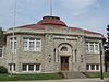 | April 14, 1976 (#76000824) | 17th and Broadway 37°20′23″N 95°15′39″W / 37.339722°N 95.260833°W / 37.339722; -95.260833 (Carnegie Library) | Parsons | |
| 3 | First State Bank | Upload image | November 1, 1982 (#82000417) | Southwestern corner of Delaware and Main Sts. 37°03′24″N 95°21′34″W / 37.056667°N 95.359444°W / 37.056667; -95.359444 (First State Bank) | Edna | |
| 4 | Harmon Site | Upload image | May 9, 1983 (#83000429) | Address restricted | Chetopa | |
| 5 | Harmon Site No. 2 (14LT323) | Upload image | May 7, 1984 (#84001239) | Address restricted | Chetopa | |
| 6 | Labette Creek Tributary Bridge | Upload image | July 2, 1985 (#85001431) | Off U.S. Route 160, 2.3 miles (3.7 km) west of Parsons 37°20′38″N 95°19′33″W / 37.343889°N 95.325833°W / 37.343889; -95.325833 (Labette Creek Tributary Bridge) | Parsons | |
| 7 | Oakwood Cemetery | Upload image | May 9, 2024 (#100010344) | 300 South Leawood Drive 37°20′12″N 95°14′25″W / 37.3366°N 95.2402°W / 37.3366; -95.2402 (Oakwood Cemetery) | Parsons | |
| 7 | Oswego Public Carnegie Library |  | June 25, 1987 (#87000956) | 704 4th St. 37°10′01″N 95°06′27″W / 37.166944°N 95.1075°W / 37.166944; -95.1075 (Oswego Public Carnegie Library) | Oswego | |
| 8 | The Parsonian Hotel |  | April 14, 2015 (#15000145) | 1725 Broadway Ave. 37°20′23″N 95°15′44″W / 37.3398°N 95.2622°W / 37.3398; -95.2622 (The Parsonian Hotel) | Parsons | |
| 9 | Parsons Filled Arch Bridge | Upload image | July 2, 1985 (#85001436) | Off U.S. Route 160, 1 mile (1.6 km) east and 1.2 miles (1.9 km) south of Parsons 37°19′09″N 95°13′51″W / 37.319167°N 95.230833°W / 37.319167; -95.230833 (Parsons Filled Arch Bridge) | Parsons | |
| 10 | Parsons Katy Hospital | Upload image | January 31, 2008 (#07001482) | 400 Katy Ave. 37°20′37″N 95°16′59″W / 37.343592°N 95.282988°W / 37.343592; -95.282988 (Parsons Katy Hospital) | Parsons | |
| 11 | Pumpkin Creek Tributary Bridge | Upload image | July 2, 1985 (#85001439) | 2 miles (3.2 km) west of Mound Valley 37°12′24″N 95°26′19″W / 37.206667°N 95.438611°W / 37.206667; -95.438611 (Pumpkin Creek Tributary Bridge) | Mound Valley | |
| 12 | Riverside Park | Upload image | July 17, 2012 (#12000412) | N. Oregon St. 37°10′30″N 95°06′03″W / 37.174885°N 95.100925°W / 37.174885; -95.100925 (Riverside Park) | Oswego | part of the New Deal-Era Resources of Kansas Multiple Property Submission |
| 13 | US Post Office-Oswego | Upload image | October 17, 1989 (#89001648) | 819 4th St. 37°10′04″N 95°06′38″W / 37.167778°N 95.110556°W / 37.167778; -95.110556 (US Post Office-Oswego) | Oswego |
Former listings
| [3] | Name on the Register | Image | Date listed | Date removed | Location | City or town | Description |
|---|---|---|---|---|---|---|---|
| 1 | East Side School | Upload image | July 11, 2002 (#02000762) | August 16, 2010 | Iowa St. 37°10′07″N 95°06′19″W / 37.1686°N 95.1053°W / 37.1686; -95.1053 (East Side School) | Oswego |
See also
- List of National Historic Landmarks in Kansas
- National Register of Historic Places listings in Kansas
References
- ^ The latitude and longitude information provided in this table was derived originally from the National Register Information System, which has been found to be fairly accurate for about 99% of listings. Some locations in this table may have been corrected to current GPS standards.
- ^ National Park Service, United States Department of the Interior, "National Register of Historic Places: Weekly List Actions", retrieved June 14, 2024.
- ^ a b Numbers represent an alphabetical ordering by significant words. Various colorings, defined here, differentiate National Historic Landmarks and historic districts from other NRHP buildings, structures, sites or objects.
- ^ "National Register Information System". National Register of Historic Places. National Park Service. March 13, 2009.
- ^ The eight-digit number below each date is the number assigned to each location in the National Register Information System database, which can be viewed by clicking the number.
- v
- t
- e

- Allen
- Anderson
- Atchison
- Barber
- Barton
- Bourbon
- Brown
- Butler
- Chase
- Chautauqua
- Cherokee
- Cheyenne
- Clark
- Clay
- Cloud
- Coffey
- Comanche
- Cowley
- Crawford
- Decatur
- Dickinson
- Doniphan
- Douglas
- Edwards
- Elk
- Ellis
- Ellsworth
- Finney
- Ford
- Franklin
- Geary
- Gove
- Graham
- Grant
- Gray
- Greeley
- Greenwood
- Hamilton
- Harper
- Harvey
- Haskell
- Hodgeman
- Jackson
- Jefferson
- Jewell
- Johnson
- Kearny
- Kingman
- Kiowa
- Labette
- Lane
- Leavenworth
- Lincoln
- Linn
- Logan
- Lyon
- Marion
- McPherson
- Meade
- Miami
- Mitchell
- Montgomery
- Morris
- Morton
- Nemaha
- Neosho
- Ness
- Norton
- Osage
- Osborne
- Ottawa
- Pawnee
- Phillips
- Pottawatomie
- Pratt
- Rawlins
- Reno
- Republic
- Rice
- Riley
- Rooks
- Rush
- Russell
- Saline
- Scott
- Sedgwick
- Seward
- Shawnee
- Sheridan
- Sherman
- Smith
- Stafford
- Stanton
- Stevens
- Sumner
- Thomas
- Trego
- Wabaunsee
- Wallace
- Washington
- Wichita
- Wilson
- Woodson
- Wyandotte
- Archaeological sites
- National Historic Landmarks
 Category
 NRHP portal


Municipalities and communities of Labette County, Kansas, United States | ||
|---|---|---|
County seat: Oswego | ||
| Cities |  | |
| Unincorporated communities | ||
| Ghost towns | ||
| Townships |
| |
| Footnotes | †This community is designated a Census-Designated Place (CDP) by the United States Census Bureau. | |
| ||


