National Register of Historic Places listings in Harper County, Kansas

This is a list of the National Register of Historic Places listings in Harper County, Kansas. It is intended to be a complete list of the properties and districts on the National Register of Historic Places in Harper County, Kansas, United States. The locations of National Register properties and districts for which the latitude and longitude coordinates are included below, may be seen in an online map.
There are 8 properties and districts listed on the National Register in the county, and one former listing.
This National Park Service list is complete through NPS recent listings posted June 14, 2024.[1]
Current listings
Map all coordinates using OpenStreetMap
Download coordinates as:
- KML
- GPX (all coordinates)
- GPX (primary coordinates)
- GPX (secondary coordinates)
| [2] | Name on the Register[3] | Image | Date listed[4] | Location | City or town | Description |
|---|---|---|---|---|---|---|
| 1 | Anthony Public Carnegie Library | Upload image | June 25, 1987 (#87000954) | 104 N. Springfield 37°09′10″N 98°00′07″W / 37.1528°N 98.0019°W / 37.1528; -98.0019 (Anthony Public Carnegie Library) | Anthony | |
| 2 | Anthony Theater | Upload image | April 18, 1991 (#91000464) | 220 W. Main St. 37°09′08″N 98°01′53″W / 37.1522°N 98.0314°W / 37.1522; -98.0314 (Anthony Theater) | Anthony | |
| 3 | I.P. Campbell Building | Upload image | July 12, 2006 (#06000600) | 116 W. Main St. 37°17′13″N 98°01′26″W / 37.2869°N 98.0239°W / 37.2869; -98.0239 (I.P. Campbell Building) | Harper | |
| 4 | First Congregational Church | Upload image | June 27, 2014 (#14000349) | 202 N. Bluff Ave. 37°09′12″N 98°01′53″W / 37.1533°N 98.0315°W / 37.1533; -98.0315 (First Congregational Church) | Anthony | |
| 5 | Harper County Courthouse |  | November 22, 1978 (#78001282) | 201 N. Jennings Ave. 37°09′14″N 98°01′46″W / 37.1539°N 98.0295°W / 37.1539; -98.0295 (Harper County Courthouse) | Anthony | |
| 6 | Harper Standpipe | Upload image | July 10, 2017 (#100001288) | 1012 Ash St. 37°17′10″N 98°01′51″W / 37.2860°N 98.0307°W / 37.2860; -98.0307 (Harper Standpipe) | Harper | |
| 7 | Old Runnymede Church | 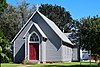 | February 6, 1973 (#73000758) | 11th and Pine Sts. 37°17′25″N 98°01′49″W / 37.2903°N 98.0303°W / 37.2903; -98.0303 (Old Runnymede Church) | Harper | |
| 8 | US Post Office-Anthony | Upload image | October 17, 1989 (#89001631) | 121 W. Steadman 37°09′14″N 98°01′08″W / 37.1539°N 98.0189°W / 37.1539; -98.0189 (US Post Office-Anthony) | Anthony |
Former listings
| [2] | Name on the Register | Image | Date listed | Date removed | Location | City or town | Description |
|---|---|---|---|---|---|---|---|
| 1 | Thompson-Wohlschlegel Round Barn | Upload image | February 21, 1985 (#85000315) | December 28, 2020 | Off U.S. Route 160, south on County Road 1485 37°16′33″N 97°58′04″W / 37.2758°N 97.9678°W / 37.2758; -97.9678 (Thompson-Wohlschlegel Round Barn) | Harper |
See also
- List of National Historic Landmarks in Kansas
- National Register of Historic Places listings in Kansas
References
Wikimedia Commons has media related to National Register of Historic Places in Harper County, Kansas.
- ^ National Park Service, United States Department of the Interior, "National Register of Historic Places: Weekly List Actions", retrieved June 14, 2024.
- ^ a b Numbers represent an alphabetical ordering by significant words. Various colorings, defined here, differentiate National Historic Landmarks and historic districts from other NRHP buildings, structures, sites or objects.
- ^ "National Register Information System". National Register of Historic Places. National Park Service. July 9, 2010.
- ^ The eight-digit number below each date is the number assigned to each location in the National Register Information System database, which can be viewed by clicking the number.
- v
- t
- e

- Allen
- Anderson
- Atchison
- Barber
- Barton
- Bourbon
- Brown
- Butler
- Chase
- Chautauqua
- Cherokee
- Cheyenne
- Clark
- Clay
- Cloud
- Coffey
- Comanche
- Cowley
- Crawford
- Decatur
- Dickinson
- Doniphan
- Douglas
- Edwards
- Elk
- Ellis
- Ellsworth
- Finney
- Ford
- Franklin
- Geary
- Gove
- Graham
- Grant
- Gray
- Greeley
- Greenwood
- Hamilton
- Harper
- Harvey
- Haskell
- Hodgeman
- Jackson
- Jefferson
- Jewell
- Johnson
- Kearny
- Kingman
- Kiowa
- Labette
- Lane
- Leavenworth
- Lincoln
- Linn
- Logan
- Lyon
- Marion
- McPherson
- Meade
- Miami
- Mitchell
- Montgomery
- Morris
- Morton
- Nemaha
- Neosho
- Ness
- Norton
- Osage
- Osborne
- Ottawa
- Pawnee
- Phillips
- Pottawatomie
- Pratt
- Rawlins
- Reno
- Republic
- Rice
- Riley
- Rooks
- Rush
- Russell
- Saline
- Scott
- Sedgwick
- Seward
- Shawnee
- Sheridan
- Sherman
- Smith
- Stafford
- Stanton
- Stevens
- Sumner
- Thomas
- Trego
- Wabaunsee
- Wallace
- Washington
- Wichita
- Wilson
- Woodson
- Wyandotte
- Archaeological sites
- National Historic Landmarks
 Category
 NRHP portal


| |
|---|---|
| Topics | |
| Lists by state |
|
| Lists by insular areas | |
| Lists by associated state | |
| Other areas | |
| Related | |
| |

Municipalities and communities of Harper County, Kansas, United States | ||
|---|---|---|
County seat: Anthony | ||
| Cities |  | |
| Unincorporated communities | ||
| Ghost towns | ||
| Townships | ||
| ||


