National Register of Historic Places listings in Peach County, Georgia
This is a list of properties and districts in Peach County, Georgia that are listed on the National Register of Historic Places (NRHP).
Map all coordinates using OpenStreetMap
Download coordinates as:
- KML
- GPX (all coordinates)
- GPX (primary coordinates)
- GPX (secondary coordinates)
This National Park Service list is complete through NPS recent listings posted June 14, 2024.[1]
- v
- t
- e
Properties on the National Register of Historic Places in Georgia by county
- Appling
- Atkinson
- Bacon
- Baker
- Baldwin
- Banks
- Barrow
- Bartow
- Ben Hill
- Berrien
- Bibb
- Bleckley
- Brantley
- Brooks
- Bryan
- Bulloch
- Burke
- Butts
- Calhoun
- Camden
- Candler
- Carroll
- Catoosa
- Charlton
- Chatham
- Chattahoochee
- Chattooga
- Cherokee
- Clarke
- Clay
- Clayton
- Clinch
- Cobb
- Coffee
- Colquitt
- Columbia
- Cook
- Coweta
- Crawford
- Crisp
- Dade
- Dawson
- Decatur
- DeKalb
- Dodge
- Dooly
- Dougherty
- Douglas
- Early
- Echols
- Effingham
- Elbert
- Emanuel
- Evans
- Fannin
- Fayette
- Floyd
- Forsyth
- Franklin
- Fulton
- Gilmer
- Glascock
- Glynn
- Gordon
- Grady
- Greene
- Gwinnett
- Habersham
- Hall
- Hancock
- Haralson
- Harris
- Hart
- Heard
- Henry
- Houston
- Irwin
- Jackson
- Jasper
- Jeff Davis
- Jefferson
- Jenkins
- Johnson
- Jones
- Lamar
- Lanier
- Laurens
- Lee
- Liberty
- Lincoln
- Long
- Lowndes
- Lumpkin
- Macon
- Madison
- Marion
- McDuffie
- McIntosh
- Meriwether
- Miller
- Mitchell
- Monroe
- Montgomery
- Morgan
- Murray
- Muscogee
- Newton
- Oconee
- Oglethorpe
- Paulding
- Peach
- Pickens
- Pierce
- Pike
- Polk
- Pulaski
- Putnam
- Quitman
- Rabun
- Randolph
- Richmond
- Rockdale
- Schley
- Screven
- Seminole
- Spalding
- Stephens
- Stewart
- Sumter
- Talbot
- Taliaferro
- Tattnall
- Taylor
- Telfair
- Terrell
- Thomas
- Tift
- Toombs
- Towns
- Treutlen
- Troup
- Turner
- Twiggs
- Union
- Upson
- Walker
- Walton
- Ware
- Warren
- Washington
- Wayne
- Webster
- Wheeler
- White
- Whitfield
- Wilcox
- Wilkes
- Wilkinson
- Worth

Current listings
| [2] | Name on the Register | Image | Date listed[3] | Location | City or town | Description |
|---|---|---|---|---|---|---|
| 1 | Byron Historic District | Upload image | June 20, 1995 (#95000739) | Roughly, along the Central GA RR tracks from Jackson St. to Vinson St. including Boulevard, Main, Church and Academy Sts 32°39′15″N 83°45′34″W / 32.6542°N 83.7594°W / 32.6542; -83.7594 (Byron Historic District) | Byron | |
| 2 | Everett Square Historic District | 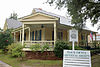 | December 30, 1994 (#94001493) | Roughly bounded by Knoxville, Vineville, Anderson, and Macon Sts. and the Central of Georgia RR tracks 32°33′15″N 83°53′29″W / 32.5542°N 83.8914°W / 32.5542; -83.8914 (Everett Square Historic District) | Fort Valley | |
| 3 | James A. Everett House |  | December 10, 1992 (#92001674) | 220 Northwoods Dr. 32°35′48″N 83°53′30″W / 32.5967°N 83.8917°W / 32.5967; -83.8917 (James A. Everett House) | Fort Valley | |
| 4 | Fort Valley Downtown and Railroad Historic District | 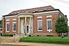 | August 12, 2010 (#10000549) | Centered around SR 49, Main St., Church St., and the railroad line 32°33′12″N 83°53′07″W / 32.5533°N 83.8853°W / 32.5533; -83.8853 (Fort Valley Downtown and Railroad Historic District) | Fort Valley | |
| 5 | Fort Valley State College Historic District |  | April 21, 2000 (#00000390) | Pear St. and State University Dr. 32°32′20″N 83°53′48″W / 32.5389°N 83.8967°W / 32.5389; -83.8967 (Fort Valley State College Historic District) | Fort Valley | Huntington Hall at Fort Valley State University |
| 6 | Henry Alexander Hunt High School Gymnasium | Upload image | August 9, 2021 (#100006788) | 600 Spruce St. 32°32′45″N 83°53′06″W / 32.5457°N 83.8850°W / 32.5457; -83.8850 (Henry Alexander Hunt High School Gymnasium) | Fort Valley | |
| 7 | Peach County Courthouse | 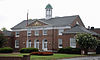 | September 18, 1980 (#80001219) | Off GA 49 32°33′12″N 83°53′17″W / 32.5533°N 83.8881°W / 32.5533; -83.8881 (Peach County Courthouse) | Fort Valley | |
| 8 | Strother's Farm | 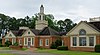 | November 25, 1980 (#80004448) | Rt. 3 32°29′17″N 83°55′33″W / 32.4881°N 83.9258°W / 32.4881; -83.9258 (Strother's Farm) | Fort Valley |
References
- ^ National Park Service, United States Department of the Interior, "National Register of Historic Places: Weekly List Actions", retrieved June 14, 2024.
- ^ Numbers represent an alphabetical ordering by significant words. Various colorings, defined here, differentiate National Historic Landmarks and historic districts from other NRHP buildings, structures, sites or objects.
- ^ The eight-digit number below each date is the number assigned to each location in the National Register Information System database, which can be viewed by clicking the number.
Wikimedia Commons has media related to National Register of Historic Places in Peach County, Georgia.
| |
|---|---|
| Topics | |
| Lists by state |
|
| Lists by insular areas | |
| Lists by associated state | |
| Other areas | |
| Related | |
| |


