National Register of Historic Places listings in Bulloch County, Georgia

This is a list of properties and districts in Bulloch County, Georgia that are listed on the National Register of Historic Places (NRHP).
Map all coordinates using OpenStreetMap
Download coordinates as:
- KML
- GPX (all coordinates)
- GPX (primary coordinates)
- GPX (secondary coordinates)
This National Park Service list is complete through NPS recent listings posted June 7, 2024.[1]
- v
- t
- e
Properties on the National Register of Historic Places in Georgia by county
- Appling
- Atkinson
- Bacon
- Baker
- Baldwin
- Banks
- Barrow
- Bartow
- Ben Hill
- Berrien
- Bibb
- Bleckley
- Brantley
- Brooks
- Bryan
- Bulloch
- Burke
- Butts
- Calhoun
- Camden
- Candler
- Carroll
- Catoosa
- Charlton
- Chatham
- Chattahoochee
- Chattooga
- Cherokee
- Clarke
- Clay
- Clayton
- Clinch
- Cobb
- Coffee
- Colquitt
- Columbia
- Cook
- Coweta
- Crawford
- Crisp
- Dade
- Dawson
- Decatur
- DeKalb
- Dodge
- Dooly
- Dougherty
- Douglas
- Early
- Echols
- Effingham
- Elbert
- Emanuel
- Evans
- Fannin
- Fayette
- Floyd
- Forsyth
- Franklin
- Fulton
- Gilmer
- Glascock
- Glynn
- Gordon
- Grady
- Greene
- Gwinnett
- Habersham
- Hall
- Hancock
- Haralson
- Harris
- Hart
- Heard
- Henry
- Houston
- Irwin
- Jackson
- Jasper
- Jeff Davis
- Jefferson
- Jenkins
- Johnson
- Jones
- Lamar
- Lanier
- Laurens
- Lee
- Liberty
- Lincoln
- Long
- Lowndes
- Lumpkin
- Macon
- Madison
- Marion
- McDuffie
- McIntosh
- Meriwether
- Miller
- Mitchell
- Monroe
- Montgomery
- Morgan
- Murray
- Muscogee
- Newton
- Oconee
- Oglethorpe
- Paulding
- Peach
- Pickens
- Pierce
- Pike
- Polk
- Pulaski
- Putnam
- Quitman
- Rabun
- Randolph
- Richmond
- Rockdale
- Schley
- Screven
- Seminole
- Spalding
- Stephens
- Stewart
- Sumter
- Talbot
- Taliaferro
- Tattnall
- Taylor
- Telfair
- Terrell
- Thomas
- Tift
- Toombs
- Towns
- Treutlen
- Troup
- Turner
- Twiggs
- Union
- Upson
- Walker
- Walton
- Ware
- Warren
- Washington
- Wayne
- Webster
- Wheeler
- White
- Whitfield
- Wilcox
- Wilkes
- Wilkinson
- Worth

Current listings
| [2] | Name on the Register | Image | Date listed[3] | Location | City or town | Description |
|---|---|---|---|---|---|---|
| 1 | Sol Akins Farm | Upload image | March 22, 1990 (#90000487) | Old Register Rd. off US 301, 1.2 mi. S of Statesboro 32°24′21″N 81°48′11″W / 32.4057°N 81.8031°W / 32.4057; -81.8031 (Sol Akins Farm) | Statesboro | On private property |
| 2 | James Alonzo Brannen House |  | September 6, 1989 (#89001154) | 112 S. Main St./US 301 32°26′46″N 81°47′00″W / 32.44625°N 81.78335°W / 32.44625; -81.78335 (James Alonzo Brannen House) | Statesboro | |
| 3 | Bulloch County Courthouse |  | September 18, 1980 (#80000978) | Courthouse Sq. 32°26′57″N 81°46′59″W / 32.449167°N 81.783056°W / 32.449167; -81.783056 (Bulloch County Courthouse) | Statesboro | |
| 4 | Donehoo-Brannen House | 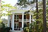 | July 7, 1995 (#95000826) | 332 Savannah Ave. 32°26′36″N 81°46′23″W / 32.44324°N 81.77292°W / 32.44324; -81.77292 (Donehoo-Brannen House) | Statesboro | Also part of the Savannah Avenue Historic District |
| 5 | East Main Street Commercial Historic District |  | September 6, 1989 (#89001155) | Roughly E. Main St./US 301 between Siebald and Oak Sts. 32°26′56″N 81°46′56″W / 32.44889°N 81.78219°W / 32.44889; -81.78219 (East Main Street Commercial Historic District) | Statesboro | |
| 6 | East Vine Street Warehouse and Depot District |  | September 6, 1989 (#89001156) | Roughly bounded by E. Vine St., Central of Georgia Railroad tracks, and Cherry St. 32°26′51″N 81°46′52″W / 32.4474°N 81.781°W / 32.4474; -81.781 (East Vine Street Warehouse and Depot District) | Statesboro | Partially demolished in 2016 |
| 7 | Dr. Madison Monroe Holland House |  | September 6, 1989 (#89001157) | 27 S. Main St./US 301 32°26′52″N 81°47′02″W / 32.44782°N 81.78386°W / 32.44782; -81.78386 (Dr. Madison Monroe Holland House) | Statesboro | |
| 8 | Jaeckel Hotel | 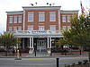 | June 17, 1982 (#82002389) | 50 E. Main St. 32°26′55″N 81°46′54″W / 32.44853°N 81.78158°W / 32.44853; -81.78158 (Jaeckel Hotel) | Statesboro | Currently used as City Hall |
| 9 | John A. McDougald House | 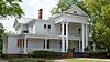 | June 21, 1982 (#82002390) | 121 S. Main St. 32°26′44″N 81°47′03″W / 32.44566°N 81.78424°W / 32.44566; -81.78424 (John A. McDougald House) | Statesboro | Currently the Beaver House Restaurant |
| 10 | Dr. John C. Nevil House |  | August 10, 1989 (#89001105) | US 301 S of Register 32°17′08″N 81°52′37″W / 32.28550°N 81.87683°W / 32.28550; -81.87683 (Dr. John C. Nevil House) | Register | |
| 11 | Norris Hotel | Upload image | October 19, 2023 (#100009454) | 9 Hill St. 32°27′02″N 81°46′57″W / 32.4506°N 81.7824°W / 32.4506; -81.7824 (Norris Hotel) | Statesboro | |
| 12 | North College Street Residential Historic District |  | September 6, 1989 (#89001158) | Roughly N. College St. from Northside Dr. to Elm St. 32°27′12″N 81°47′06″W / 32.453333°N 81.785°W / 32.453333; -81.785 (North College Street Residential Historic District) | Statesboro | |
| 13 | North Main Street Commercial Historic District |  | September 6, 1989 (#89001159) | Roughly N. Main St. between Courtland and W. Main Sts. 32°26′57″N 81°47′00″W / 32.449167°N 81.783333°W / 32.449167; -81.783333 (North Main Street Commercial Historic District) | Statesboro | |
| 14 | William W. Olliff Farm | 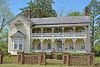 | December 4, 1987 (#87002113) | New Hope Rd. 32°17′25″N 81°56′33″W / 32.29032°N 81.94238°W / 32.29032; -81.94238 (William W. Olliff Farm) | Register | |
| 15 | William G. Raines House |  | August 31, 1987 (#87000942) | 106 S. Main St. 32°26′47″N 81°47′00″W / 32.4465°N 81.78333°W / 32.4465; -81.78333 (William G. Raines House) | Statesboro | Currently known as "The Historic Statesboro Inn" |
| 16 | Savannah Avenue Historic District | 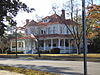 | November 15, 1996 (#96001339) | Along Savannah Ave. and E. Grady St. between S. Crescent Cir. 32°26′38″N 81°46′24″W / 32.443889°N 81.773333°W / 32.443889; -81.773333 (Savannah Avenue Historic District) | Statesboro | |
| 17 | South Main Street Historic District |  | September 6, 1989 (#89001160) | Roughly S. Main St. between W. Main and Vine Sts. 32°26′55″N 81°47′00″W / 32.448611°N 81.783333°W / 32.448611; -81.783333 (South Main Street Historic District) | Statesboro | |
| 18 | South Main Street Residential Historic District |  | September 6, 1989 (#89001161) | Roughly College Ln., Southern Railway right-of-way, Walnut, Mikell, and S. Main Sts. 32°26′25″N 81°47′01″W / 32.440278°N 81.783611°W / 32.440278; -81.783611 (South Main Street Residential Historic District) | Statesboro | |
| 19 | Statesboro City Hall and Fire Station | Upload image | September 6, 1989 (#89001162) | Siebald and Courtland Sts. 32°26′59″N 81°46′56″W / 32.449722°N 81.782222°W / 32.449722; -81.782222 (Statesboro City Hall and Fire Station) | Statesboro | Demolished before 1997 |
| 20 | Stewart Stores | 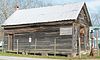 | May 20, 1993 (#93000430) | Jct. of Railroad St. (Mullet Row) and Grady St. 32°32′18″N 81°55′55″W / 32.53836°N 81.93199°W / 32.53836; -81.93199 (Stewart Stores) | Portal | Only one of the stores is still there as of 2016. It is also known as the Portal Drugstore and is a Place in Peril. |
| 21 | Dr. James A. Stewart House |  | May 27, 1993 (#93000439) | Grady St. 32°32′22″N 81°55′52″W / 32.53949°N 81.93120°W / 32.53949; -81.93120 (Dr. James A. Stewart House) | Portal | |
| 22 | Upper Lott's Creek Primitive Baptist Church and Cemetery |  | December 4, 2008 (#08000967) | Metter-Portal Hwy. and Westside Rd. 32°29′17″N 81°58′23″W / 32.48792°N 81.97306°W / 32.48792; -81.97306 (Upper Lott's Creek Primitive Baptist Church and Cemetery) | Metter | |
| 23 | US Post Office-Statesboro |  | September 6, 1989 (#89001163) | 26 S. Main St./US 301 32°26′52″N 81°47′00″W / 32.44775°N 81.7833°W / 32.44775; -81.7833 (US Post Office-Statesboro) | Statesboro | Was also used as City Hall. Currently houses offices of AgSouth Farm Credit |
| 24 | West Main Street Commercial Historic District | 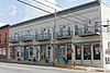 | September 6, 1989 (#89001164) | Roughly W. Main St. between Walnut and N. and S. Main Sts. 32°26′56″N 81°47′03″W / 32.448889°N 81.784167°W / 32.448889; -81.784167 (West Main Street Commercial Historic District) | Statesboro |
References
- ^ National Park Service, United States Department of the Interior, "National Register of Historic Places: Weekly List Actions", retrieved June 7, 2024.
- ^ Numbers represent an alphabetical ordering by significant words. Various colorings, defined here, differentiate National Historic Landmarks and historic districts from other NRHP buildings, structures, sites or objects.
- ^ The eight-digit number below each date is the number assigned to each location in the National Register Information System database, which can be viewed by clicking the number.
Wikimedia Commons has media related to National Register of Historic Places in Bulloch County, Georgia.
| |
|---|---|
| Topics | |
| Lists by state |
|
| Lists by insular areas | |
| Lists by associated state | |
| Other areas | |
| Related | |
| |


