National Register of Historic Places listings in Dougherty County, Georgia
This is a list of properties and districts in Dougherty County, Georgia that are listed on the National Register of Historic Places (NRHP).
Map all coordinates using OpenStreetMap
Download coordinates as:
- KML
- GPX (all coordinates)
- GPX (primary coordinates)
- GPX (secondary coordinates)
This National Park Service list is complete through NPS recent listings posted June 7, 2024.[1]
- v
- t
- e
Properties on the National Register of Historic Places in Georgia by county
- Appling
- Atkinson
- Bacon
- Baker
- Baldwin
- Banks
- Barrow
- Bartow
- Ben Hill
- Berrien
- Bibb
- Bleckley
- Brantley
- Brooks
- Bryan
- Bulloch
- Burke
- Butts
- Calhoun
- Camden
- Candler
- Carroll
- Catoosa
- Charlton
- Chatham
- Chattahoochee
- Chattooga
- Cherokee
- Clarke
- Clay
- Clayton
- Clinch
- Cobb
- Coffee
- Colquitt
- Columbia
- Cook
- Coweta
- Crawford
- Crisp
- Dade
- Dawson
- Decatur
- DeKalb
- Dodge
- Dooly
- Dougherty
- Douglas
- Early
- Echols
- Effingham
- Elbert
- Emanuel
- Evans
- Fannin
- Fayette
- Floyd
- Forsyth
- Franklin
- Fulton
- Gilmer
- Glascock
- Glynn
- Gordon
- Grady
- Greene
- Gwinnett
- Habersham
- Hall
- Hancock
- Haralson
- Harris
- Hart
- Heard
- Henry
- Houston
- Irwin
- Jackson
- Jasper
- Jeff Davis
- Jefferson
- Jenkins
- Johnson
- Jones
- Lamar
- Lanier
- Laurens
- Lee
- Liberty
- Lincoln
- Long
- Lowndes
- Lumpkin
- Macon
- Madison
- Marion
- McDuffie
- McIntosh
- Meriwether
- Miller
- Mitchell
- Monroe
- Montgomery
- Morgan
- Murray
- Muscogee
- Newton
- Oconee
- Oglethorpe
- Paulding
- Peach
- Pickens
- Pierce
- Pike
- Polk
- Pulaski
- Putnam
- Quitman
- Rabun
- Randolph
- Richmond
- Rockdale
- Schley
- Screven
- Seminole
- Spalding
- Stephens
- Stewart
- Sumter
- Talbot
- Taliaferro
- Tattnall
- Taylor
- Telfair
- Terrell
- Thomas
- Tift
- Toombs
- Towns
- Treutlen
- Troup
- Turner
- Twiggs
- Union
- Upson
- Walker
- Walton
- Ware
- Warren
- Washington
- Wayne
- Webster
- Wheeler
- White
- Whitfield
- Wilcox
- Wilkes
- Wilkinson
- Worth

Current listings
| [2] | Name on the Register | Image | Date listed[3] | Location | City or town | Description |
|---|---|---|---|---|---|---|
| 1 | Albany District Pecan Growers' Exchange | 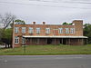 | May 10, 1984 (#84000979) | 211-213 Roosevelt Ave. 31°34′53″N 84°09′06″W / 31.581389°N 84.151667°W / 31.581389; -84.151667 (Albany District Pecan Growers' Exchange) | Albany | |
| 2 | Albany Housefurnishing Company |  | June 17, 1982 (#82002402) | 226 W. Broad Ave. 31°34′35″N 84°09′09″W / 31.576389°N 84.1525°W / 31.576389; -84.1525 (Albany Housefurnishing Company) | Albany | |
| 3 | Albany Railroad Depot Historic District |  | May 20, 1982 (#82002403) | E. Roosevelt Ave. 31°34′55″N 84°09′00″W / 31.581944°N 84.15°W / 31.581944; -84.15 (Albany Railroad Depot Historic District) | Albany | |
| 4 | Albany Theatre |  | August 21, 2006 (#06000733) | 107 N. Jackson St. 31°34′37″N 84°09′14″W / 31.576944°N 84.153889°W / 31.576944; -84.153889 (Albany Theatre) | Albany | |
| 5 | Bridge House |  | November 19, 1974 (#74000672) | 112 N. Front St. 31°34′40″N 84°08′56″W / 31.577778°N 84.148889°W / 31.577778; -84.148889 (Bridge House) | Albany | |
| 6 | Carnegie Library of Albany |  | July 15, 1982 (#82002404) | 215 N. Jackson St. 31°34′44″N 84°09′14″W / 31.578889°N 84.153889°W / 31.578889; -84.153889 (Carnegie Library of Albany) | Albany | |
| 7 | John A. Davis House |  | October 16, 1980 (#80001014) | 514 Pine Ave. 31°34′41″N 84°09′38″W / 31.578056°N 84.160556°W / 31.578056; -84.160556 (John A. Davis House) | Albany | |
| 8 | Davis-Exchange Bank Building |  | February 23, 1984 (#84000981) | 100-102 N. Washington St. 31°34′37″N 84°09′04″W / 31.576944°N 84.151111°W / 31.576944; -84.151111 (Davis-Exchange Bank Building) | Albany | |
| 9 | Samuel Farkas House | 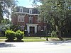 | November 9, 1977 (#77000419) | 328 W. Broad Ave. 31°34′35″N 84°09′18″W / 31.576389°N 84.155°W / 31.576389; -84.155 (Samuel Farkas House) | Albany | |
| 10 | Lustron House at 1200 Fifth Avenue | 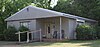 | March 18, 1996 (#96000214) | 1200 Fifth Ave. 31°35′34″N 84°10′42″W / 31.59280°N 84.17844°W / 31.59280; -84.17844 (Lustron House at 1200 Fifth Avenue) | Albany | |
| 11 | Lustron House at 711 Ninth Avenue |  | March 18, 1996 (#96000213) | 711 Ninth Ave. 31°35′53″N 84°10′00″W / 31.598056°N 84.166667°W / 31.598056; -84.166667 (Lustron House at 711 Ninth Avenue) | Albany | Coordinates given are on the wrong block (a block to the south) |
| 12 | Mount Zion Baptist Church |  | August 10, 1995 (#95000911) | 328 W. Whitney Ave. 31°34′18″N 84°09′20″W / 31.571667°N 84.155556°W / 31.571667; -84.155556 (Mount Zion Baptist Church) | Albany | |
| 13 | Municipal Auditorium | 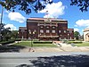 | June 25, 1974 (#74000673) | 301 Pine Ave. 31°34′43″N 84°09′16″W / 31.578611°N 84.154444°W / 31.578611; -84.154444 (Municipal Auditorium) | Albany | |
| 14 | New Albany Hotel | 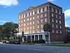 | June 17, 1982 (#82002405) | 245 Pine St. 31°34′49″N 84°09′05″W / 31.58021°N 84.15133°W / 31.58021; -84.15133 (New Albany Hotel) | Albany | |
| 15 | Old St. Teresa's Catholic Church | 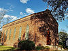 | April 1, 1975 (#75000589) | 313 Residence Ave. 31°34′59″N 84°09′17″W / 31.583056°N 84.154722°W / 31.583056; -84.154722 (Old St. Teresa's Catholic Church) | Albany | |
| 16 | Rosenberg Brothers Department Store |  | August 19, 1982 (#82002406) | 126 N. Washington St. 31°34′41″N 84°09′04″W / 31.578056°N 84.151111°W / 31.578056; -84.151111 (Rosenberg Brothers Department Store) | Albany | Albany Herald Headquarters |
| 17 | W. E. Smith House | 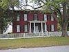 | August 30, 1977 (#77000420) | 516 Flint Ave. 31°34′46″N 84°09′37″W / 31.579444°N 84.160278°W / 31.579444; -84.160278 (W. E. Smith House) | Albany | First brick house in Albany |
| 18 | St. Nicholas Hotel |  | December 19, 1991 (#91001851) | 141 Flint Ave., 300-310 Washington St. 31°34′48″N 84°09′05″W / 31.58°N 84.151389°W / 31.58; -84.151389 (St. Nicholas Hotel) | Albany | |
| 19 | Tift Park |  | November 15, 1993 (#93001179) | Bounded by N. Jefferson St., 5th Ave., 7th Ave. and Palmyra Rd. 31°35′38″N 84°09′31″W / 31.593889°N 84.158611°W / 31.593889; -84.158611 (Tift Park) | Albany | |
| 20 | U.S. Post Office and Courthouse |  | June 22, 1979 (#79003105) | 345 W. Broad Ave. 31°34′38″N 84°09′20″W / 31.577222°N 84.155556°W / 31.577222; -84.155556 (U.S. Post Office and Courthouse) | Albany | |
| 21 | Union Station Depot |  | February 13, 1975 (#75000590) | Roosevelt Ave. and N. Front St. 31°34′54″N 84°08′59″W / 31.581579°N 84.149652°W / 31.581579; -84.149652 (Union Station Depot) | Albany |
References
- ^ National Park Service, United States Department of the Interior, "National Register of Historic Places: Weekly List Actions", retrieved June 7, 2024.
- ^ Numbers represent an alphabetical ordering by significant words. Various colorings, defined here, differentiate National Historic Landmarks and historic districts from other NRHP buildings, structures, sites or objects.
- ^ The eight-digit number below each date is the number assigned to each location in the National Register Information System database, which can be viewed by clicking the number.
Wikimedia Commons has media related to National Register of Historic Places in Dougherty County, Georgia.
| |
|---|---|
| Topics | |
| Lists by state |
|
| Lists by insular areas | |
| Lists by associated state | |
| Other areas | |
| Related | |
| |


