Vesterbro, Aarhus
Neighborhood in Aarhus Municipality, Central Denmark Region, Kingdom of Denmark
56°09′43″N 10°11′53″E / 56.161996°N 10.198120°E / 56.161996; 10.1981208000
Vesterbro is a neighbourhood of Aarhus, Denmark. It is located in the Aarhus C district, west of the city centre of Indre By. Vesterbro used to be farmland outside the city walls, and the neighbourhood's development progressed, when the city walls of Aarhus were demolished in 1851.[citation needed]
Description
The neighbourhood of Vesterbro is part of Midtbyen and comprise the area between the university, Indre By, the broad railway yard bordering Frederiksbjerg, Aabyhøj and Aarhus V. The oldest part of Vesterbro is located close to Indre By. Places of interest includes the Aarhus Botanical Gardens, the open-air museum of Den Gamle By (one of Denmark's most popular attractions), the hospital of Amtssygehuset and the culture centre of Godsbanen. The main square of Vesterbro Torv used to be a market square for the trading of livestock such as pigs in the 1880s.[citation needed] Now it is probably the busiest junction on Vesterbro.
The inner part of Vesterbro comprise the residential quarters of Ø-gade kvarteret (lit.: the island-street quarter), where most streets are named after Danish islands and CeresByen, a new quarter currently being built on the grounds of the former Ceres Brewery.[1]
Gallery
-
 A typical street in Øgadekvarteret, Vesterbro
 -
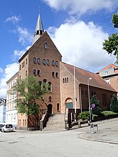 A church in Øgadekvarteret
 -
 A firestation
 -
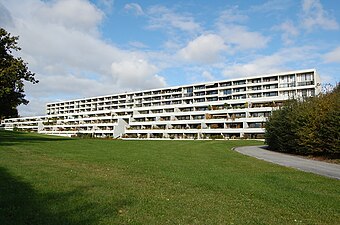 Modern apartment buildings from 1970 in Vesterbro
 -
 Prismet (lit.: the prism), a visible and central landmark of the Vesterbro skyline
 -
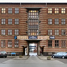 Main entrance to the hospital of Amtssygehuset


References
- ^ "Ø-gade Kvarteret" (in Danish). Aarhus Kommune. 1983. Retrieved 28 February 2015.
Sources
Wikimedia Commons has media related to Vesterbro, Aarhus.
- Vesterbro: Danish
- v
- t
- e
City of Aarhus
The Midtown boroughs: Indre By, Docklands, Frederiksbjerg, Langenæs, Marselisborg, Nørre Stenbro, Trøjborg, Vesterbro

- Ballehage Beach
- Botanical Gardens
- City Hall Park
- Concert Hall Park
- Forestry Botanical Garden
- Den Permanente
- Hasle Hills
- Langenæs Park
- Marselisborg Deer Park
- Marselisborg Forests
- Marselisborg Hospitals Park
- Marienlyst Park
- Mindeparken
- Mølleparken
- Nordre Cemetery
- Riis Forest
- Skanseparken
- Skjoldhøjkilen
- Skæring Hede
- St. Olufs Cemetery
- Tangkrogen
- Vennelystparken
- Vestereng
- Vestre Cemetery
- University Park
- Åkrogen
- Åparken
- Aarhus Cathedral
- Aarhus Methodist Church
- Åby Church
- Åbyhøj Church
- Brabrand Church
- Catholic Church of Our Lady
- Christian's Church
- Church of Our Lady
- Egå Church
- Ellevang Church
- Fredens Church
- Frederik's Church
- Hasle Church
- Holme Church
- Langenæs Church
- Lyseng Church
- Møllevang Church
- Ravnsbjerg Church
- Risskov Church
- St. John's Church
- St. Luke's Church
- St. Mark's Church
- St. Nicholas' Church
- St. Paul's Church
- Tilst Church
- Tranbjerg Church
- Skejby Church
- Vejlby Church
- Viby Church
- Aarhus University
- Aarhus School of Architecture
- Aarhus School of Marine and Technical Engineering
- Business Academy Aarhus
- School of Media and Journalism
- Central Library
- Deaconal Folk High School
- Jutland Art Academy'
- KaosPilot
- Ole Rømer Observatory
- Royal Academy of Music, Aarhus/Aalborg
- State and University Library
- VIA University College
 Category

56°09′43″N 10°11′53″E / 56.161996°N 10.198120°E / 56.161996; 10.198120


