Frederiksbjerg
Neighborhood in Aarhus Municipality, Central Denmark Region, Denmark
56°08′49″N 10°12′04″E / 56.147°N 10.201°E / 56.147; 10.2018000
Frederiksbjerg is a borough in Aarhus, Denmark.
Frederiksbjerg is part of the postal district Aarhus C and is located just south of the historical city centre, separated from it by a broad railway yard and connected by three bridges. Despite being part of the inner city, Frederiksbjerg has its own charm and character and express some of the first large scale attempts to plan the development of Aarhus as a city. With around 20,000 inhabitants, it is basically a residential area, but with three large shopping streets; Bruunsgade, Jægergårdsgade, and Frederiks Allé.
History
Frederiksbjerg was annexed by Aarhus in 1874, when the city limits was moved south from the railway yard. The city was at bursting point for expansion, due to the accelerating industrialization and population growth, and new building sites were desperately needed. From 1870-75 Frederiksbjergs population rose from just 300 to 2,000 citizens and with the building of the new bridge of Bruuns Bro, the admission accelerated further. This development inspired the City Council to adopt a strategy of large scale city planning, something hitherto unheard of in Aarhus and Denmark in general. Several plans was proposed and worked out, but the architect Hack Kampmann and city engineer to Copenhagen Charles Ambt's innovative plan from 1898, ended up as the most influential. Frederiksbjerg was soon fully developed and populated thereafter.
Gallery
-
 Skyline
 -
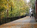 Hallssti. This shared bikeway marks the northern limits of Frederiksbjerg
 -
 Frederiks Allé, an important and heavily trafficked transport street.
 -
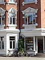
 Jægergårdsgade, main shopping street
 -
 The long avenue of Stadion Allé
 -
 Ingerslevs Boulevard, main street and park area
 -
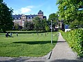 Skanseparken, a recreational park in the eastern parts


- Institutions
-
 Institute for Sports, under Aarhus University.
 -
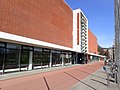 Frederiksbjerg Idrætscenter, a sports center and swimminghall
 -

-
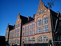
 Public school of Læssøesgades Skole
 -
 Public school of Frederiksbjerg Skole from 2016
 -
 Fjordsgade, a public center for sports and non-profit associations
 -
 The church of Lukas Kirken.
 -

-
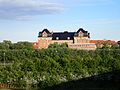
 Marselisborg Hospital


- Architecture
-
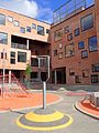
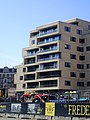 Frederiks Plads, under construction
 -
 Højhusene Marselis Boulevard, modernist highrises (1967)
 -
 Strandparken, typical Danish funkis (1938)
 -
 Frederiksbjerg-bo, neo-classical architecture (1927)
 -
 Skansen (1909) at Skanseparken.
 -
 Typical townhouses
 -
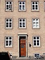
 Historicist architecture from around 1900 is abundant
 -
-
 Three- and four-storey buildings are common


Sources
- Magistratens 2. Afdeling (1979): Frederiksbjerg Øst - Århus Kommuneatlas, Aarhus Municipality. On the history and development of Frederiksbjerg. (in Danish)
- Magistratens 2. Afdeling (1981): Frederiksbjerg Vest - Århus Kommuneatlas, Aarhus Municipality. On the history and development of Frederiksbjerg. (in Danish)
External links
Wikimedia Commons has media related to Frederiksbjerg.
- v
- t
- e
City of Aarhus
The Midtown boroughs: Indre By, Docklands, Frederiksbjerg, Langenæs, Marselisborg, Nørre Stenbro, Trøjborg, Vesterbro

- Ballehage Beach
- Botanical Gardens
- City Hall Park
- Concert Hall Park
- Forestry Botanical Garden
- Den Permanente
- Hasle Hills
- Langenæs Park
- Marselisborg Deer Park
- Marselisborg Forests
- Marselisborg Hospitals Park
- Marienlyst Park
- Mindeparken
- Mølleparken
- Nordre Cemetery
- Riis Forest
- Skanseparken
- Skjoldhøjkilen
- Skæring Hede
- St. Olufs Cemetery
- Tangkrogen
- Vennelystparken
- Vestereng
- Vestre Cemetery
- University Park
- Åkrogen
- Åparken
- Aarhus Cathedral
- Aarhus Methodist Church
- Åby Church
- Åbyhøj Church
- Brabrand Church
- Catholic Church of Our Lady
- Christian's Church
- Church of Our Lady
- Egå Church
- Ellevang Church
- Fredens Church
- Frederik's Church
- Hasle Church
- Holme Church
- Langenæs Church
- Lyseng Church
- Møllevang Church
- Ravnsbjerg Church
- Risskov Church
- St. John's Church
- St. Luke's Church
- St. Mark's Church
- St. Nicholas' Church
- St. Paul's Church
- Tilst Church
- Tranbjerg Church
- Skejby Church
- Vejlby Church
- Viby Church
- Aarhus University
- Aarhus School of Architecture
- Aarhus School of Marine and Technical Engineering
- Business Academy Aarhus
- School of Media and Journalism
- Central Library
- Deaconal Folk High School
- Jutland Art Academy'
- KaosPilot
- Ole Rømer Observatory
- Royal Academy of Music, Aarhus/Aalborg
- State and University Library
- VIA University College
 Category

Authority control databases | |
|---|---|
| International |
|
| National |
|


