Savernake, New South Wales
Town in New South Wales, Australia
35°44′0″S 146°03′0″E / 35.73333°S 146.05000°E / -35.73333; 146.05000Savernake (/ˈsævərnæk/ SAV-ər-nak) is a village and rural community in the southern Riverina region of New South Wales, Australia. The village is located on the Riverina Highway, east of Berrigan, and in the Federation Council local government area.
The area has a population of 94 [1]
The Savernake School of the Arts Hall holds events throughout the year for the community.
History
The first Savernake Post Office opened on 1 January 1890 and was renamed Warmatta in 1892 (and closed in 1927). The second Savernake Post Office opened in 1895 and closed in 1994.[2]
Savernake Football Club
Savernake Football Club won the 1902 Clear Hills Football Association premiership, winning five of their six games.[3] They continued to play in the Clear Hills FA in 1903, then played in the Berrigan Football Association in 1904.[4]
Savenake played in the Federal Football Association from 1905[5] to 1908.[6]
Savernake FC was reformed and joined the Coreen & District Football Association in 1924[7] and in 1926 were under the guidance of Paddy Rector.[8] Savernake FC continued to play in the Coreen & DFA from 1927 to 1928. Savernake then withdrew from the Coreen & DFA at the association's 1929 Annual General Meeting.[9] They then returned to the Coreen & DFA in 1930.[10] It appears there has not been a football from Savernake since 1930.
Heritage listings
Savernake has a number of heritage-listed sites, including:
- 2341 Mulwala Road: Savernake Station[11]
Today
The village consists of a hall, primary school, a now abandoned shop and a few houses. The hall is used from time to time by the HotHouse theatre group, based in Albury-Wodonga, for small touring theatrical productions.[12]
The main agricultural products of the area include sheep (for meat and wool), beef cattle, dryland cropping and pig production as well as some irrigated rice production.[13]
The Savernake area has been part of a CSIRO project to understand the role of remnant woodlands in agricultural landscapes.[14]
-
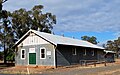 The School of Arts Hall at Savernake
 -
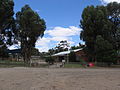 Savernake Public School
 -
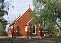 The Catholic Church at Savernake


References
- ^ "2016 Census QuickStats: Savernake".
- ^ Premier Postal History, Post Office List, retrieved 11 June 2009
- ^ "1902 - Savernake". The Corowa Free Press (NSW). 26 August 1902. p. 2. Retrieved 20 September 2021.
- ^ "1904 - Savernake". Corowa Free Press. The Corowa Free Press (NSW). 17 June 1904. p. 2. Retrieved 20 September 2021.
- ^ "1906 - Federal Football Association". The Corowa Chronicle (NSW). 20 June 1906. p. 3. Retrieved 4 October 2021.
- ^ "1907 - Savenake FC". The Corowa Chronicle. 1 May 1907. p. 3. Retrieved 22 September 2021.
- ^ "1924 - Savenake". Albury Banner and Wodonga Express. The Albury Banner and Wodonga Express (NSW). 23 May 1924. p. 6. Retrieved 21 September 2021.
- ^ "1926 - Notes on the game". Corowa Chronicle. The Corowa Chronicle (NSW). 5 June 1926. p. 1. Retrieved 20 September 2021.
- ^ "1929 - Coreen & District FA". The Corowa Free Press (NSW). 24 May 1929. p. 3. Retrieved 21 September 2021.
- ^ "1930 - Coreen & DFA". Corowa Free Press. The Corowa Free Press (NSW). 29 July 1930. p. 3. Retrieved 21 September 2021.
- ^ "Savernake Station and Moveable Heritage". New South Wales State Heritage Register. Department of Planning & Environment. H01907. Retrieved 18 May 2018.
 Text is licensed by State of New South Wales (Department of Planning and Environment) under CC-BY 4.0 licence.
 - ^ HotHouse Theatre Archived 8 December 2006 at the Wayback Machine – Touring. Retrieved 19 January 2007.
- ^ CSIRO – SAND research project - Agriculture in the Savernake region. Retrieved 19 January 2007.
- ^ CSIRO SAND research project. Retrieved 19 January 2007.
External links
![]() Media related to Savernake, New South Wales at Wikimedia Commons
Media related to Savernake, New South Wales at Wikimedia Commons
- v
- t
- e
Towns in the Federation Council local government area
Main Article: Local government areas of New South Wales


