Rannock, New South Wales
Town in New South Wales, Australia
34°36′32″S 147°15′50″E / 34.60889°S 147.26389°E / -34.60889; 147.26389Rannock is a rural community in the central north part of the Riverina. It is situated by road, about 14 kilometres (8.7 mi) east of Methul and 23 kilometres (14 mi) north of Coolamon. At the 2021 census, Rannock had a population of 78 people.[1]
Rannock Post Office opened on 21 December 1908 and closed in 1970.[2]
Gallery
Wikimedia Commons has media related to Rannock, New South Wales.
-
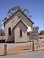 Uniting Church Rannock

Notes and references
- ^ a b Australian Bureau of Statistics (28 June 2022). "Rannock (State Suburb)". 2021 Census QuickStats. Retrieved 18 March 2023.

- ^ Premier Postal History, Post Office List, retrieved 11 June 2009
- v
- t
- e
Towns and localities in the Coolamon Shire local government area
Main Article: Local government areas of New South Wales


