Sant'Angelo a Fasanella
You can help expand this article with text translated from the corresponding article in Italian. (January 2022) Click [show] for important translation instructions.
- Machine translation, like DeepL or Google Translate, is a useful starting point for translations, but translators must revise errors as necessary and confirm that the translation is accurate, rather than simply copy-pasting machine-translated text into the English Wikipedia.
- Do not translate text that appears unreliable or low-quality. If possible, verify the text with references provided in the foreign-language article.
- You must provide copyright attribution in the edit summary accompanying your translation by providing an interlanguage link to the source of your translation. A model attribution edit summary is
Content in this edit is translated from the existing Italian Wikipedia article at [[:it:Sant'Angelo a Fasanella]]; see its history for attribution. - You may also add the template
{{Translated|it|Sant'Angelo a Fasanella}}to the talk page. - For more guidance, see Wikipedia:Translation.
Comune in Campania, Italy
Sant'Angelo a Fasanella | |
|---|---|
Comune | |
| Comune di Sant'Angelo a Fasanella | |
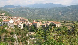 Panoramic view | |
 Sant'Angelo a Fasanella within the Province of Salerno and Campania | |
Location of Sant'Angelo a Fasanella  | |
40°27′N 15°21′E / 40.450°N 15.350°E / 40.450; 15.350 | |
| Country | Italy |
| Region | Campania |
| Province | Salerno (SA) |
| Government | |
| • Mayor | Gaspare Salamone |
| Area | |
| • Total | 32 km2 (12 sq mi) |
| Elevation | 515 m (1,690 ft) |
| Population (31 December 2010)[2] | |
| • Total | 730 |
| • Density | 23/km2 (59/sq mi) |
| Demonym | Santangiolesi |
| Time zone | UTC+1 (CET) |
| • Summer (DST) | UTC+2 (CEST) |
| Postal code | 84027 |
| Dialing code | 0828 |
| Patron saint | Michael the Archangel |
| Saint day | 29 September |
| Website | Official website |
Sant'Angelo a Fasanella is a town and comune in the province of Salerno in the Campania region of south-western Italy.
Geography
The town is located in the north-east of Cilento, close to the mountain range of the Alburni. Its municipal territory is bordered by Bellosguardo, Corleto Monforte, Ottati, Petina and Roscigno.
References
External links
Wikimedia Commons has media related to Sant'Angelo a Fasanella.
- Official website (in Italian)
- v
- t
- e
- Acerno
- Agropoli
- Albanella
- Alfano
- Altavilla Silentina
- Amalfi
- Angri
- Aquara
- Ascea
- Atena Lucana
- Atrani
- Auletta
- Baronissi
- Battipaglia
- Bellizzi
- Bellosguardo
- Bracigliano
- Buccino
- Buonabitacolo
- Caggiano
- Calvanico
- Camerota
- Campagna
- Campora
- Cannalonga
- Capaccio
- Casal Velino
- Casalbuono
- Casaletto Spartano
- Caselle in Pittari
- Castel San Giorgio
- Castel San Lorenzo
- Castelcivita
- Castellabate
- Castelnuovo Cilento
- Castelnuovo di Conza
- Castiglione del Genovesi
- Cava de' Tirreni
- Celle di Bulgheria
- Centola
- Ceraso
- Cetara
- Cicerale
- Colliano
- Conca dei Marini
- Controne
- Contursi Terme
- Corbara
- Corleto Monforte
- Cuccaro Vetere
- Eboli
- Felitto
- Fisciano
- Furore
- Futani
- Giffoni Sei Casali
- Giffoni Valle Piana
- Gioi
- Giungano
- Ispani
- Laureana Cilento
- Laurino
- Laurito
- Laviano
- Lustra
- Magliano Vetere
- Maiori
- Mercato San Severino
- Minori
- Moio della Civitella
- Montano Antilia
- Monte San Giacomo
- Montecorice
- Montecorvino Pugliano
- Montecorvino Rovella
- Monteforte Cilento
- Montesano sulla Marcellana
- Morigerati
- Nocera Inferiore
- Nocera Superiore
- Novi Velia
- Ogliastro Cilento
- Olevano sul Tusciano
- Oliveto Citra
- Omignano
- Orria
- Ottati
- Padula
- Pagani
- Palomonte
- Pellezzano
- Perdifumo
- Perito
- Pertosa
- Petina
- Piaggine
- Pisciotta
- Polla
- Pollica
- Pontecagnano Faiano
- Positano
- Postiglione
- Praiano
- Prignano Cilento
- Ravello
- Ricigliano
- Roccadaspide
- Roccagloriosa
- Roccapiemonte
- Rofrano
- Romagnano al Monte
- Roscigno
- Rutino
- Sacco
- Sala Consilina
- Salento
- Salerno
- Salvitelle
- San Cipriano Picentino
- San Giovanni a Piro
- San Gregorio Magno
- San Mango Piemonte
- San Marzano sul Sarno
- San Mauro Cilento
- San Mauro la Bruca
- San Pietro al Tanagro
- San Rufo
- San Valentino Torio
- Sant'Angelo a Fasanella
- Sant'Arsenio
- Sant'Egidio del Monte Albino
- Santa Marina
- Santomenna
- Sanza
- Sapri
- Sarno
- Sassano
- Scafati
- Scala
- Serramezzana
- Serre
- Sessa Cilento
- Siano
- Sicignano degli Alburni
- Stella Cilento
- Stio
- Teggiano
- Torchiara
- Torraca
- Torre Orsaia
- Tortorella
- Tramonti
- Trentinara
- Valle dell'Angelo
- Vallo della Lucania
- Valva
- Vibonati
- Vietri sul Mare
Authority control databases | |
|---|---|
| International |
|
| National |
|
 | This Campanian location article is a stub. You can help Wikipedia by expanding it. |
- v
- t
- e


