North Carolina Highway 615
State highway in Currituck County, North Carolina, US
North Carolina Highway 615 | ||||
|---|---|---|---|---|
 | ||||
| Route information | ||||
| Maintained by NCDOT | ||||
| Length | 14.9 mi[1] (24.0 km) | |||
| Existed | 1963–present | |||
| Major junctions | ||||
| South end |  NC 168 in Currituck NC 168 in Currituck | |||
| North end | Princess Anne Road at the Virginia state line | |||
| Location | ||||
| Country | United States | |||
| State | North Carolina | |||
| Counties | Currituck | |||
| Highway system | ||||
| ||||


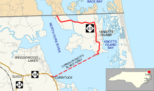
North Carolina Highway 615 (NC 615) is a primary state highway in the U.S. state of North Carolina. It connects Knotts Island with mainland North Carolina via the Currituck–Knotts Island Ferry.
Route description
NC 615 connects the community of Knotts Island with both mainland North Carolina and Virginia. The 14.9 miles (24.0 km) route begins at NC 168, in Currituck, where it goes east and crosses over the Currituck Sound, via the Currituck-Knotts Island Ferry. On Knotts Island, it continues north for nine miles (14 km) before reaching the Virginia state line. On the island, the route is well signed and borders the Mackay Island National Wildlife Refuge.
Ferry service, which predates the highway by one year (1962), was established originally to shorten the travel time for Knott's Island school children to their school on the mainland (in Barco). The ferry is free with year-round service with travel times of 45 minutes on average.[2]
The highway is the northeasternmost primary route in the state. The entire route is concurrent with North Carolina Bicycle Route 4.[3]
History
Established around 1963 as a new primary routing, NC 615 was located only on Knotts Island. At some point before 2001, the highway was extended overlapping the Currituck-Knotts Island Ferry, ending on the mainland at Courthouse Road.[citation needed] On April 9, 2013, it was extended .36 miles (0.58 km) northwest along Courthouse Road to end at its current southern terminus at NC 168. Justification for the extension was to connect to North Carolina Highway 168 and remove a gap.[4]
Major intersections
The entire route is in Currituck County.
| Location | mi[1] | km | Destinations | Notes | |
|---|---|---|---|---|---|
| Currituck | 0.0 | 0.0 | NC 168 (Caratoke Highway) – Moyock, Kill Devil Hills | ||
| Currituck Sound | 0.4 | 0.64 |  Currituck-Knotts Island Ferry Currituck-Knotts Island Ferry | ||
| | 14.9 | 24.0 | Princess Anne Road | Virginia state line | |
| 1.000 mi = 1.609 km; 1.000 km = 0.621 mi | |||||
References
- ^ a b Google (June 14, 2013). "North Carolina Highway 615" (Map). Google Maps. Google. Retrieved June 14, 2013.
- ^ "NCDOT: Ferry Routes". Retrieved January 3, 2011.
- ^ "NC 4 - North Line Trace". North Carolina Bike Routes Beta. Walk Bike North Carolina Bicycle Routes. Retrieved March 11, 2016.
- ^ "NC 615 Route Change (2013-04-09)" (PDF). North Carolina Department of Transportation. April 9, 2013. Retrieved June 14, 2013.
External links
KML file (edit • help)
Template:Attached KML/North Carolina Highway 615
KML is from Wikidata
 Media related to North Carolina Highway 615 at Wikimedia Commons
- NCRoads.com: N.C. 615
- v
- t
- e
- Bays
- Onslow Bay
- Raleigh Bay
- Back Bay
- Knotts Island Bay
- National Seashores
- Cape Hatteras National Seashore
- Cape Lookout National Seashore
- Wildlife Refuges
- Back Bay National Wildlife Refuge
- Mackay Island National Wildlife Refuge
- Currituck National Wildlife Refuge
- Pea Island National Wildlife Refuge
- State Parks
- False Cape State Park
- Jockey's Ridge State Park
- State Coastal Reserves
- Kitty Hawk Woods
- Buxton Woods
- Preserves
- Nags Head Woods Preserve
- Roanoke Island Marshes Preserve
- Museums, zoos, and institutes
- North Carolina Aquarium on Roanoke Island
- Graveyard of the Atlantic Museum
- University of North Carolina - Coastal Studies Institute
- Other
- Mountains-to-Sea Trail
- Pine Island Audubon Sanctuary
- Fort Raleigh National Historic Site
- Wright Brothers National Memorial
- Currituck Banks North Carolina National Estuarine Research Reserve
- Run Hill State Natural Area
- Wildlife
- Banker horse
- Red wolf
- Routes
- North Carolina Highway 12
- North Carolina Highway 45
- U.S. Highway 64
- U.S. Highway 64 Bypass
- U.S. Highway 158
- North Carolina Highway 345
- North Carolina Highway 400
- North Carolina Highway 615
- Historic Albemarle Tour
- North Carolina Ferry System
- Bridges
- Virginia Dare Memorial Bridge
- Marc Basnight Bridge
- Herbert C. Bonner Bridge
- Wright Memorial Bridge
- William B. Umstead Bridge
- Washington Baum Bridge
- Melvin R. Daniels Bridge
- Rodanthe Bridge
- Mid-Currituck Bridge
- Captain Richard Etheridge Bridge
- Events and places
- Pea Island Life-Saving Station
- Chicamacomico Life-Saving Station
- Roanoke Colony
- Graveyard of the Atlantic
- Torpedo Alley
- Battle of the Atlantic
- Hatteras Weather Bureau Station
- Freedmen's Colony of Roanoke Island
- People
- Roanoke people
- Croatan
- Wanchese
- Manteo
- John White
- Richard Grenville
- Blackbeard
- Raleigh
- Virginia Dare
- Marc Basnight


