Hatteras Inlet
Estuary in North Carolina, U.S.
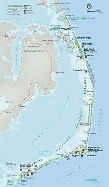
Hatteras Inlet is an estuary in North Carolina, located along the Outer Banks, separating Hatteras Island and Ocracoke Island. It connects the Atlantic Ocean to the Pamlico Sound. Hatteras Inlet is located entirely within Hyde County.
History
The first "Hatteras Inlet" was formed south of the current inlet, but closed around 1764. The modern "Hatteras Inlet" was formed on September 7, 1846, by a violent gale. This massive storm was the same storm that opened present-day Oregon Inlet. The new inlet at Hatteras became a profitable inlet because it gave the Inner Banks, NC a quicker and easier route to travel to and from the Gulf Stream. It was easier to come into this inlet from the north than to Ocracoke. Because of the increase in commerce, Hatteras Village Post Office was established in 1858. The initial invasion of the North Carolina coast on Hatteras Island during the Civil War, called the Battle of Hatteras Inlet Batteries, came from Hatteras Inlet on August 28–29, 1861. The two Confederate forts guarding the inlet quickly fell.[1]
Hatteras Inlet today
The inlet today is approximately two miles across, but this distance changes daily because of the convection of brackish water. No bridge crosses Hatteras Inlet. A fleet of eight ferries, owned by the North Carolina Department of Transportation, provides a free 60-minute ride year round to people who want to traverse the inlet from Hatteras to Ocracoke. These ferries connect North Carolina State Highway 12 between the two islands.[2]
Further reading
Claiborne S. Young (2005). Cruising Guide to Coastal North Carolina. Winston-Salem, NC: John F. Blair. ISBN 0-89587-314-1.
Map
Google Maps - Hatteras Inlet
References
35°11′31″N 75°45′40″W / 35.19194°N 75.76111°W / 35.19194; -75.76111
| Preceded by | Beaches of The Outer Banks | Succeeded by |
- v
- t
- e
- Bays
- Onslow Bay
- Raleigh Bay
- Back Bay
- Knotts Island Bay
- Sounds
- Currituck Sound
- Albemarle Sound
- Croatan Sound
- Roanoke Sound
- Pamlico Sound
- Core Sound
- Back Sound
- Inlets
- Oregon Inlet
- New Inlet
- Isabel Inlet
- Hatteras Inlet
- Ocracoke Inlet
- Drum Inlet
- Barden Inlet
- National Seashores
- Cape Hatteras National Seashore
- Cape Lookout National Seashore
- Wildlife Refuges
- Back Bay National Wildlife Refuge
- Mackay Island National Wildlife Refuge
- Currituck National Wildlife Refuge
- Pea Island National Wildlife Refuge
- State Parks
- False Cape State Park
- Jockey's Ridge State Park
- State Coastal Reserves
- Kitty Hawk Woods
- Buxton Woods
- Preserves
- Nags Head Woods Preserve
- Roanoke Island Marshes Preserve
- Museums, zoos, and institutes
- North Carolina Aquarium on Roanoke Island
- Graveyard of the Atlantic Museum
- University of North Carolina - Coastal Studies Institute
- Other
- Mountains-to-Sea Trail
- Pine Island Audubon Sanctuary
- Fort Raleigh National Historic Site
- Wright Brothers National Memorial
- Currituck Banks North Carolina National Estuarine Research Reserve
- Run Hill State Natural Area
- Wildlife
- Banker horse
- Red wolf
- Routes
- North Carolina Highway 12
- North Carolina Highway 45
- U.S. Highway 64
- U.S. Highway 64 Bypass
- U.S. Highway 158
- North Carolina Highway 345
- North Carolina Highway 400
- North Carolina Highway 615
- Historic Albemarle Tour
- North Carolina Ferry System
- Bridges
- Virginia Dare Memorial Bridge
- Marc Basnight Bridge
- Herbert C. Bonner Bridge
- Wright Memorial Bridge
- William B. Umstead Bridge
- Washington Baum Bridge
- Melvin R. Daniels Bridge
- Rodanthe Bridge
- Mid-Currituck Bridge
- Captain Richard Etheridge Bridge
- Events and places
- Pea Island Life-Saving Station
- Chicamacomico Life-Saving Station
- Roanoke Colony
- Graveyard of the Atlantic
- Torpedo Alley
- Battle of the Atlantic
- Hatteras Weather Bureau Station
- Freedmen's Colony of Roanoke Island
- People
- Roanoke people
- Croatan
- Wanchese
- Manteo
- John White
- Richard Grenville
- Blackbeard
- Raleigh
- Virginia Dare
- Marc Basnight
| Authority control databases: National |
|
|---|


