Navajo Mountain
Landform in Utah and Arizona, United States

Navajo Mountain

Navajo Mountain
- San Juan, County, Utah, U.S.
- Coconino County, Arizona, U.S.
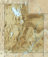
Navajo Mountain (Navajo: Naatsisʼáán) is a peak in San Juan County, Utah, with its southern flank extending into Coconino County, Arizona, in the United States.[3] It holds an important place in the traditions of three local Native American tribes. The summit is the highest point on the Navajo Nation.[2]
Geologic history
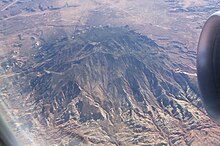
Navajo Mountain is a prominent free-standing laccolith, a dome-shaped body of igneous rock that intruded into sedimentary layers and lifted up the overlying layer. The igneous rock at the core of the mountain is wrapped in sedimentary layers. Such igneous intrusions have been exposed by erosion and well studied in similar mountain ranges on the Colorado Plateau, such as the Henry Mountains, the Abajo Mountains, and the La Sal Range.[4]
The Colorado Plateau is made of mostly flat-lying layers of sedimentary rock that record paleoclimate extremes ranging from oceans to widespread deserts over the last 1.8 billion years. The peak of Navajo Mountain, at approximately 10,388 feet (3,166 m), is made up of uplifted Dakota Sandstone deposited during the Cretaceous Period (approximately 66-138 million years ago).[4] Other formations exposed on the surface of the mountain include the Jurassic sequence of the Morrison Formation, Entrada Sandstone, Carmel Formation, and Navajo Sandstone.[5][6]
Cultural history

The Navajo Mountain region has special cultural significance to the Navajo people, who know it as Naatsisʼáán ("Earth Head" or "Pollen Mountain").[7] Together with Rainbow Bridge to the northwest, Navajo Mountain figures prominently as the first settlement area in western Navajo origin stories. Following the military defeat of the Diné (Navajo people) by United States forces in 1863, the political landscape was changed by new boundaries and major physical alterations. The establishment of Rainbow Bridge National Monument (1910), and the filling of Glen Canyon by Lake Powell in 1963, has facilitated tourism of this previously remote region. Access to Navajo Mountain is still regulated by the sovereign Navajo Nation, and a permit is required to hike in the region. Climbing the mountain itself is forbidden.[8]
Before becoming part of the Navajo Nation, the area was inhabited by the Ancestral Puebloans. Their descendants, the Hopi, call Navajo Mountain Tokonave, or "Heart of the Earth".[9] Ruins in the area of Navajo Mountain are still strongly associated with certain Hopi clans, with priests still making pilgrimages to shrines in the area.[9]
Before 1933, when the area between the Colorado and San Juan Rivers and the Arizona border was added to the Navajo reservation, the area was known as the Paiute Strip, and the mountain itself was known as Paiute Mountain, due to the population of San Juan Paiutes living between the mountain and Monument Valley.[10]
The community of Navajo Mountain, Utah is to the east.
Ecology
The Navajo Mountain beardtongue (Penstemon navajoa) is a rare plant limited mainly to the upper elevation slopes of Navajo Mountain.[11]
See also
 Mountains portal
 Utah portal


References
- ^ a b "San Juan". NGS Data Sheet. National Geodetic Survey, National Oceanic and Atmospheric Administration, United States Department of Commerce. Retrieved 2014-02-08.
- ^ a b "Navajo Mountain, Utah". Peakbagger.com. Retrieved 2014-02-08.
- ^ U.S. Geological Survey Geographic Names Information System: Navajo Mountain
- ^ a b "Navajo Mountain, Utah". NASA Earth Observatory. Retrieved 2020-10-29.
- ^ Hackman, R.J., Photogeologic map of the Navajo Mountain-13 quadrangle, San Juan County, Utah, and Coconino County, Arizona. U.S. Geological Survey, Miscellaneous Geologic Investigations Map I-184. 1956. Map Scale: 1:24,000.
- ^ Hackman, R.J., Photogeologic map of the Navajo Mountain-14 quadrangle, San Juan County, Utah, and Coconino County, Arizona. U.S. Geological Survey, Miscellaneous Geologic Investigations Map I-238. 1957. Map Scale: 1:24,000.
- ^ Houk, Rose (2003). The Mountains Know Arizona. Phoenix: Arizona Highways Books. ISBN 978-1893860872.
- ^ "Travel Navajo Nation". Navajo Nation Parks and Recreation. Retrieved 2014-02-07.
- ^ a b Courlander, Harold (1971). The Fourth World of the Hopis: the epic story of the Hopi Indians as preserved in their legends and traditions. Albuquerque: New Mexico University Press. p. 239. ISBN 978-0826310118.
- ^ Trimble, Stephen (1993). The People: Indians of the American Southwest. Santa Fe, NM: School of American Research. p. 536. ISBN 9780933452367.
- ^ "Penstemon navajoa". The Nature Conservancy. Retrieved 2014-02-07.
External links
Wikimedia Commons has media related to Navajo Mountain.
- "Navajo Mountain (UT)". SummitPost.org.
- v
- t
- e
(Yavapai County)
- Boundary Cone
- Fortification Hill
- Mount Wilson
- Mount Union
- Castle Dome
- Carr Peak
- Miller Peak
- Aubrey Peak
- Hualapai Peak
- Lime Peak
- Mae West Peaks
- Four Peaks
- Mount Ord
- East End
- McDowell Peak
- Mount McDowell
- Thompson Peak
- Mount Ballard (Arizona)
- Camelback Mountain
- Mummy Mountain
- Piestewa Peak
- South Mountains
- Sunnyslope Mountain
- Ibex Peak
- Agassiz Peak
- Doyle Peak
- Fremont Peak
- Mount Bigelow
- Mount Lemmon
- Pusch Ridge
- Thimble Peak
- Mount Hopkins
- Mount Wrightson
- Mount Turnbull
- Mistake Peak
- Granite Mountain
- Black Dome
- Sentinel Peak
- Tumamoc Hill
- Apache Peak
- Black Mesa (Navajo County)
- Escudilla Mountain
- Mount Baldy
- Agathla Peak
- Agua Caliente Mountains
- Agua Dulce Mountains
- Antelope Hill
- Aquarius Mountains
- Artillery Mountains
- Atascosa Mountains
- Aubrey Hills
- Baboquivari Peak
- Balakai Mesa
- Beaver Dam Mountains
- Belmont Mountains
- Bill Williams Mountain
- Bitsihuitsos Butte
- Black Hills (Greenlee County)
- Black Mesa (Apache-Navajo Counties)
- Black Mesa (Warm Springs)
- Black Mountain (Maricopa County)
- Black Mountain (Pima County)
- Blackjack Mountains
- Bryan Mountains
- Buckskin Mountain (Arizona-Utah)
- Buckskin Mountains (La Paz County)
- Bush Head
- Cabeza Prieta Mountains
- Canelo Hills
- Carrizo Mountains
- Cerro Colorado Mountains
- Chocolate Mountains
- Copper Mountains
- Coyote Mountains
- Date Creek Mountains
- Dome Rock Mountains
- Dos Cabezas Mountains
- Etoi Ki
- Excalibur
- Galiuro Mountains
- Gavilan Peak
- Gila Bend Mountains
- Gila Mountains (Graham County)
- Gila Mountains (Yuma County)
- Goldfield Mountains
- Grand Wash Cliffs
- Granite Mountains
- Granite Wash Mountains
- Growler Mountains
- Gu Achi Peak
- Guadalupe Mountains
- Harcuvar Mountains
- Harquahala Mountains
- House Mountain
- Hunts Mesa
- Isis Temple
- John the Baptist Mountains
- Juniper Mesa
- Kaibab Plateau
- Kofa Mountains
- Laguna Mountains
- Las Guijas Mountains
- Lime Mountain (Maricopa County}
- Little Harquahala Mountains
- Little Rincon Mountains
- Lukachukai Mountains
- Madrean Sky Islands
- Mescal Mountains
- Mineral Mountains
- Moccasin Mountains
- Mohave Mountains
- Mohawk Mountains
- Mount Trumbull
- Muggins Mountains
- Mustang Mountains
- Navajo Mountain
- The Needles
- New River Mountains
- New Water Mountains
- Newton Butte
- Painted Rock Mountains
- Pajarito Mountains
- Patagonia Mountains
- Peacock Mountains
- Picacho Peak
- Picketpost Mountain
- Pinnacle Peak
- Poachie Range
- Poston Butte
- Rawhide Mountains
- Sacaton Mountains
- San Luis Mountains
- Santa Maria Mountains
- Sevenmile Mountains
- Sierra San Antonio
- Sierra Estrella
- Sierra Madre Occidental
- Sierra Pinta
- Silver Bell Mountains
- Squaw Tits
- Sugarloaf Mountain
- Sunset Mountains
- Swisshelm Mountains
- Tempe Butte
- Temple Butte
- Tinajas Altas Mountains
- Tordillo Mountain
- Tortolita Mountains
- Trigo Mountains
- Tule Mountains
- Tumacacori Mountains
- Virgin Mountains
- Vulcan's Throne
- Vulture Mountains
- Waterman Mountains
- Weaver Mountains
- West Silver Bell Mountains
- White Tank Mountains
- Wickenburg Mountains
| Authority control databases: National |
|
|---|


