Mohave Mountains
Landform in Mohave County, Arizona


Mohave Mountains
Mohave Mountains in Arizona
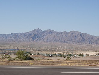
The Mohave Mountains are a small 18-mi (29 km) long[1] mountain range of northwest Arizona. The range is a northwest trending range in southwest Mohave County that parallels a southeast-flowing stretch of the Colorado River, the Arizona-California border. The range also forms the southwest border of a flatland region to its east and north, namely, Dutch Flat which lies east, at the south end of Sacramento Valley. Lake Havasu City, AZ on the Colorado, lays opposite the southwest flank of the range, where the London Bridge was reconstructed at Lake Havasu.
Interstate 40 traverses east from Needles, California adjacent the north of the range through the flatland region, and turns north through the Sacramento Valley to Kingman, Arizona.
The northwest terminus of the range merges into hills and a rocky region on the east shore of the Colorado River called The Needles.[2] The Topock Gorge of the Colorado and The Needles lay at the east border of the Chemehuevi Mountains of California; both the Chemehuevi and Sacramento Mountains force the Colorado River to flow southeasterly.
Range description
The Mohave Mountains are mostly northwest-trending with a slight curve to the east at the south terminus, into the southwest region of Dutch Flat. There is no central ridgeline; instead the northwest becomes lower elevation hills, bordering The Needles region. The center and south of the range is centered around a massif which contains the range highpoint, Crossman Peak, at 5,103 feet (1,555 m).[3]
Since the elevation of Lake Havasu City is 602 feet (183 m),[4] the height of the range from the surrounding countryside is 4000–4500 ft.
Access
Arizona State Route 95 borders the Colorado River's east bank and allows access to the range. Unimproved roads from Arizona 95 access the northwest and the north of the range, where Lake Havasu Heights is located.
An unimproved road from Arizona 95 (Dutch Flat Rd) traverses northeasterly at the range's southeast flank. The route reaches Dutch Flat, from where the complete eastern side of the range is met with unimproved access roads. A dirt route from Franconia Wash, (northwest Dutch Flat, Franconia on I-40), accesses the northeast of Crossman Peak. Another unimproved road starts at the end of Bison Blvd in Lake Havasu City and follows Falls Springs Wash to a gate, where it continues up a very steep route to a radio antenna complex along the ridgeline, half a mile from Crossman Peak. The gated portion of the route is open to hikers, and the ridgeline offers views of Dutch Flat and the Lake Havasu valley.[5]
The unimproved roads into Dutch Flat, the range's northwest flank, and also the range's north, can be accessed from Interstate 40. I-40 lies 7-mi[6] due-north of the range's north terminus.
-
 Crossman Peak, from Arizona 95
 -
 The Needles, at Topock Gorge
(view ~southeast on the Colorado)


References
External links
Wikimedia Commons has media related to Mohave Mountains.
- Mohave Mountains Range, (range coordinates)
- Arizona Mountain Ranges, Primary Table
- v
- t
- e
(Yavapai County)
- Boundary Cone
- Fortification Hill
- Mount Wilson
- Mount Union
- Castle Dome
- Carr Peak
- Miller Peak
- Aubrey Peak
- Hualapai Peak
- Lime Peak
- Mae West Peaks
- Four Peaks
- Mount Ord
- East End
- McDowell Peak
- Mount McDowell
- Thompson Peak
- Mount Ballard (Arizona)
- Camelback Mountain
- Mummy Mountain
- Piestewa Peak
- South Mountains
- Sunnyslope Mountain
- Ibex Peak
- Agassiz Peak
- Doyle Peak
- Fremont Peak
- Mount Bigelow
- Mount Lemmon
- Pusch Ridge
- Thimble Peak
- Mount Hopkins
- Mount Wrightson
- Mount Turnbull
- Mistake Peak
- Granite Mountain
- Black Dome
- Sentinel Peak
- Tumamoc Hill
- Apache Peak
- Black Mesa (Navajo County)
- Escudilla Mountain
- Mount Baldy
- Agathla Peak
- Agua Caliente Mountains
- Agua Dulce Mountains
- Antelope Hill
- Aquarius Mountains
- Artillery Mountains
- Atascosa Mountains
- Aubrey Hills
- Baboquivari Peak
- Balakai Mesa
- Beaver Dam Mountains
- Belmont Mountains
- Bill Williams Mountain
- Bitsihuitsos Butte
- Black Hills (Greenlee County)
- Black Mesa (Apache-Navajo Counties)
- Black Mesa (Warm Springs)
- Black Mountain (Maricopa County)
- Black Mountain (Pima County)
- Blackjack Mountains
- Bryan Mountains
- Buckskin Mountain (Arizona-Utah)
- Buckskin Mountains (La Paz County)
- Bush Head
- Cabeza Prieta Mountains
- Canelo Hills
- Carrizo Mountains
- Cerro Colorado Mountains
- Chocolate Mountains
- Copper Mountains
- Coyote Mountains
- Date Creek Mountains
- Dome Rock Mountains
- Dos Cabezas Mountains
- Etoi Ki
- Excalibur
- Galiuro Mountains
- Gavilan Peak
- Gila Bend Mountains
- Gila Mountains (Graham County)
- Gila Mountains (Yuma County)
- Goldfield Mountains
- Grand Wash Cliffs
- Granite Mountains
- Granite Wash Mountains
- Growler Mountains
- Gu Achi Peak
- Guadalupe Mountains
- Harcuvar Mountains
- Harquahala Mountains
- House Mountain
- Hunts Mesa
- Isis Temple
- John the Baptist Mountains
- Juniper Mesa
- Kaibab Plateau
- Kofa Mountains
- Laguna Mountains
- Las Guijas Mountains
- Lime Mountain (Maricopa County}
- Little Harquahala Mountains
- Little Rincon Mountains
- Lukachukai Mountains
- Madrean Sky Islands
- Mescal Mountains
- Mineral Mountains
- Moccasin Mountains
- Mohave Mountains
- Mohawk Mountains
- Mount Trumbull
- Muggins Mountains
- Mustang Mountains
- Navajo Mountain
- The Needles
- New River Mountains
- New Water Mountains
- Newton Butte
- Painted Rock Mountains
- Pajarito Mountains
- Patagonia Mountains
- Peacock Mountains
- Picacho Peak
- Picketpost Mountain
- Pinnacle Peak
- Poachie Range
- Poston Butte
- Rawhide Mountains
- Sacaton Mountains
- San Luis Mountains
- Santa Maria Mountains
- Sevenmile Mountains
- Sierra San Antonio
- Sierra Estrella
- Sierra Madre Occidental
- Sierra Pinta
- Silver Bell Mountains
- Squaw Tits
- Sugarloaf Mountain
- Sunset Mountains
- Swisshelm Mountains
- Tempe Butte
- Temple Butte
- Tinajas Altas Mountains
- Tordillo Mountain
- Tortolita Mountains
- Trigo Mountains
- Tule Mountains
- Tumacacori Mountains
- Virgin Mountains
- Vulcan's Throne
- Vulture Mountains
- Waterman Mountains
- Weaver Mountains
- West Silver Bell Mountains
- White Tank Mountains
- Wickenburg Mountains


