Mount Nantai
Stratovolcano on the island of Honshu, Japan
You can help expand this article with text translated from the corresponding article in Japanese. (March 2022) Click [show] for important translation instructions.
- Machine translation, like DeepL or Google Translate, is a useful starting point for translations, but translators must revise errors as necessary and confirm that the translation is accurate, rather than simply copy-pasting machine-translated text into the English Wikipedia.
- Consider adding a topic to this template: there are already 3,682 articles in the main category, and specifying
|topic=will aid in categorization. - Do not translate text that appears unreliable or low-quality. If possible, verify the text with references provided in the foreign-language article.
- You must provide copyright attribution in the edit summary accompanying your translation by providing an interlanguage link to the source of your translation. A model attribution edit summary is
Content in this edit is translated from the existing Japanese Wikipedia article at [[:ja:男体山]]; see its history for attribution. - You may also add the template
{{Translated|ja|男体山}}to the talk page. - For more guidance, see Wikipedia:Translation.


Mount Nantai
Honshū, Japan
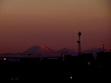
Mount Nantai (男体山, Nantai-san, lit. 'male-body mountain',[2] also called Mount Futara (二荒山, Futāra-san)[2]) is a stratovolcano in the Nikkō National Park in Tochigi Prefecture, in central Honshū, the main island of Japan. The mountain is 2,486 metres (8,156 ft) high.[1] A prominent landmark, it can be seen on clear days from as far as Saitama, a city 100 km (62 mi) away.
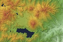
Alongside Mount Nikkō-Shirane, Mount Nantai is one of the newest volcanic edifices in the National Park. Scientific studies of the volcano's geological structure began in 1957 and have established that it was formed roughly 23,000 years ago and that its last eruption was 7000 years ago.[3] The volcano was classified as active by the Japan Meteorological Agency in June 2017.[4]
Since its first known ascent by Buddhist monk Shōdō Shōnin in the 8th century AD, Mount Nantai has become a sacred mountain and a site of pilgrimage in Buddhism and Shinto. As such, it is currently maintained by Futarasan jinja, a Shinto shrine whose go-shintai (御神体) constitutes Mount Nantai.[5] With Tōshō-gū and Rinnō-ji, the site forms the Shrines and Temples of Nikkō, a UNESCO World Heritage Site. Archaeological excavations conducted here from the 19th to 20th centuries have unearthed many artifacts, dating from the end of the Nara period in the 8th century AD to the Edo period from the 17th to 19th centuries. A few of these have been declared Important Cultural Properties by the Japanese Agency for Cultural Affairs.
Mount Nantai is listed among the 100 Famous Japanese Mountains as written by mountaineer and author Kyūya Fukada.
Toponymy
Literally, the two kanji characters that make up the name, 男 and 体, mean "man" and "body" respectively, and so together the combined word 男体 means "male body".[2] Mount Nantai is said to have been the father in a family of mountain deities in Shinto, of which the neighboring Mount Nyohō is the mother and Mount Tarō the eldest son.[6]
Trekking
The mountain is popular with hikers, and the trail to the summit starts through a gate at Futarasan Shrine's Chūgushi (中宮祠, middle shrine). The gate is open between 5 May and 25 October.[7]
Mount Nantai is one of the 100 famous mountains in Japan.
Volcanic activity
In September 2008, the Japan Meteorological Agency was asked to reclassify Mount Nantai as "active" based upon work by Yasuo Ishizaki and colleagues of Toyama University showing evidence of an eruption approximately 7000 years ago.[8]
Mount Nantai as a sacred mountain

Archaeologists affirm that during the Yayoi period the most common go-shintai (御神体) (a yorishiro housing a kami) in the earliest Shinto shrines was a nearby mountain peak supplying with its streams water, and therefore life, to the plains below where people lived.[5]
Mount Nantai constitutes Futarasan Shrine's go-shintai, and the shrine is an important example of this ancient type of mountain cult.[5] Significantly, the name Nantai (男体) itself means "man's body".[5] The mountain not only provides water to the rice paddies below, but has the shape of the phallic stone rods found in pre-agricultural Jōmon sites.[5]
See also
References
- ^ a b "地理院地図 / GSI Maps|国土地理院" [GSI Maps | Geospatial Information Authority of Japan]. Geospatial Information Authority of Japan (in Japanese). Retrieved 2 January 2022.
- ^ a b c Daijirin (in Japanese). Akira Matsumura, 松村明 (Dai 2-han ed.). Tōkyō: Sanseidō. 3 November 1995. ISBN 4-385-13900-8. OCLC 34720033.
{{cite book}}: CS1 maint: others (link) - ^ Yamamoto, Takahiro (4 February 2015). "日本の主要第四紀火山の積算マグマ噴出量階段図 (日光火山群)" [Cumulative volume step-diagrams for eruptive magmas from major Quaternary volcanoes in Japan (Nikko Volcanoes)] (PDF). Geological Survey of Japan. Retrieved 3 January 2022.
- ^ "List of Active Volcanoes in Japan" (PDF). Japan Meteorological Agency. Retrieved 3 January 2022.
- ^ a b c d e Hall, John Whitney (1993). Brown, Delmer (ed.). The Cambridge History of Japan, Vol. 1. Cambridge, UK: Cambridge University Press. ISBN 0-521-22352-0. OCLC 17483588.
- ^ Fukada, Kyūya (1964). One Hundred Mountains of Japan. Martin Hood. Honolulu: University of Hawaiʻi Press. ISBN 0-8248-4785-7. OCLC 930010674.
- ^ "Futarasan Jinja Shrine Chugushi | Temple". japantravel.navitime.com. Retrieved 26 March 2022.
- ^ "Mount Nantai in Nikko may still be active volcano, say researchers". Mainichi Daily News. 13 September 2008. Archived from the original on 18 September 2008.
External links
Wikimedia Commons has media related to Mount Nantai.
- Nantai-Nyoho Volcano Group – Geological Survey of Japan
- "Nantaisan". Global Volcanism Program. Smithsonian Institution. Retrieved 24 June 2021.
- v
- t
- e
- Mt. Rishiri
- Mt. Rausu
- Mt. Shari
- Mt. Akan
- Mt. Taisetsu
- Mt. Tomuraushi
- Mt. Tokachi
- Mt. Poroshiri
- Mt. Yōtei
Jōshinetsu region
- Mt. Iwaki
- Hakkōda
- Hachimantai
- Mt. Iwate
- Mt. Hayachine
- Mt. Chokai
- Mt. Gassan
- Mt. Asahi
- Mt. Zaō
- Mt. Iide
- Mt. Azuma
- Mt. Adatara
- Mt. Bandai
- Mt. Aizu-Koma
- Mt. Echigo (Uonuma-Koma)
- Mt. Hiragatake
- Mt. Makihata
- Mt. Hiuchigatake
- Mt. Shibutsu
- Mt. Tanigawa
- Mt. Naeba
- Mt. Myōkō
- Hiuchiyama
- Mt. Amakazari
- Mt. Takatsuma
| Hida Mountains (Northern Alps) | |
|---|---|
| Kiso Mountains (Central Alps) | |
| Akaishi Mountains (Southern Alps) | |
| Others |
|
- Kyūya Fukada
- List of mountains in Japan
- Three-thousanders (in Japan)
 Media related to 100 Famous Japanese Mountains at Wikimedia Commons
Authority control databases | |
|---|---|
| International |
|
| National |
|
| Geographic |
|


