Kolatak
Village in Kalbajar District, Azerbaijan
Place
Kolatak Քոլատակ | |
|---|---|
| Kolatağ | |
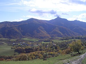 A view of Kolatak | |
| Coordinates: 40°00′11″N 46°36′00″E / 40.00306°N 46.60000°E / 40.00306; 46.60000 | |
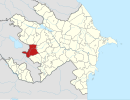
| Country |  Azerbaijan Azerbaijan |
| • District | Kalbajar |
| Population (2015)[1] | |
| • Total | 250 |
| Time zone | UTC+4 (AZT) |
Kolatak (Armenian: Քոլատակ; Azerbaijani: Kolatağ) is a village located in the Kalbajar District of Azerbaijan, in the disputed region of Nagorno-Karabakh. The village has an ethnic Armenian-majority population, and also had an Armenian majority in 1989.[2]
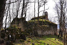
Situated on a mountain above the village is the Armenian monastery of Hakobavank, from between the 7th and 13th centuries.
History
During the Soviet period, the village was a part of the Mardakert District of the Nagorno-Karabakh Autonomous Oblast.
Historical heritage sites
Historical heritage sites in and around the village include the monastery of Hakobavank (Armenian: Հակոբավանք; also known as the monastery of Metsaranits, Մեծառանից) from between the 7th and 13th centuries, the fortress of Kachaghakaberd (Armenian: Կաչաղակաբերդ) in the mountains to the south - an important fortress in the medieval Armenian Principality of Khachen, the medieval fortress of Berdakar (Armenian: Բերդաքար), khachkars from between the 9th and 13th centuries, the church of Koshik Anapat (Armenian: Կոշիկ անապատ), the fortress of Isarantsots (Armenian: Իսարանցոց) and a cemetery from between the 12th and 13th centuries, a 13th-century church, the village of Alan Veran (Armenian: Ալան Վերան) and a cemetery from between the 16th and 18th centuries, the 17th-century Mandur Church (Armenian: Մանդուռի եկեղեցի, romanized: Manduri Yekeghetsi), the 17th/18th-century village of Hndzan (Armenian: Հնձան), a 19th-century oil mill, and a cave.[1]
Economy and culture
The population is mainly engaged in agriculture and animal husbandry. As of 2015, the village has a municipal building, a secondary school, and a medical centre.[1]
Demographics
The village had 273 inhabitants in 2005,[3] and 250 inhabitants in 2015.[1]
Gallery
-
 A view of the village
 -
 Hakobavank complex
 -
 Scenery around Kolatak
 -
 Armenian-language inscription in the monastery of Hakobavank
 -
 Mountains around Kolatak
 -
 The 12th/13th-century Koshik Anapat Church


References
- ^ a b c d Hakob Ghahramanyan. "Directory of socio-economic characteristics of NKR administrative-territorial units (2015)".
- ^ Андрей Зубов. "Андрей Зубов. Карабах: Мир и Война". drugoivzgliad.com.
- ^ "The Results of the 2005 Census of the Nagorno-Karabakh Republic" (PDF). National Statistic Service of the Republic of Artsakh.
External links
Wikimedia Commons has media related to Kolatağ.
- Kolatak at GEOnet Names Server
- A short documentary about the village on YouTube
- v
- t
- e
Capital: Martakert

- Aghabekalanj
- Arajadzor
- Chankatagh
- Chapar
- Chldran
- Drmbon
- Garnakar
- Ghazarahogh
- Getavan
- Harutyunagomer
- Haterk
- Imar
- Jraberd
- Khnkavan
- Kichan
- Kmkadzor
- Kochoghot
- Kolatak
- Kusapat
- Maghavuz
- Mehmana
- Mets Shen
- Mokhratagh
- Nareshtar
- Nerkin Horatagh
- Nor Ghazanchi
- Poghosagomer
- Seysulan
- Shahmasur
- Tblghu
- Tonashen
- Tsaghkashen
- Tsmakahogh
- Vaghuhas
- Vank
- Vardadzor
- Varnkatagh
- Verin Horatagh
- Zaglik
- Zardakhach
Portal:
 Geography


