Charnwood
| Charnwood | |||
|---|---|---|---|
 | |||
| | |||
| Land |  Storbritannia Storbritannia | ||
| Konst. land |  England England | ||
| Region | Øst-Midlands | ||
| Adm. grevskap | Leicestershire | ||
| Seremonielt grevskap | Leicestershire | ||
| Status | Distrikt | ||
| Grunnlagt | 1. april 1974 | ||
| Adm. senter | Loughborough | ||
| Areal | 279,06 km² | ||
| Befolkning | 166 100 (2011) | ||
| Bef.tetthet | 595,21 innb./km² | ||
| ONS-kode | 31UC | ||
 Charnwood 52°46′08″N 1°12′14″V | |||
Charnwood på Commons | |||
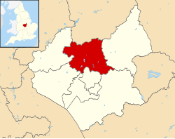
Charnwood er et administrativt distrikt i Leicestershire i England. Det har navn etter skogen Charnwood Forest, som ligger i distriktet. Største by og administrasjonssenter er Loughborough.
Distriktet ble opprettet 1. april 1974 ved sammenslåing av Loughborough, Shepshed og Barrow upon Soar landdistrikt. Distriktet har et areal på 279,06 km² og hadde 166 100 innbyggere i 2011.[1]
Steder i distriktet
- Anstey
- Barkby, Barkby Thorpe, Barrow upon Soar, Beeby, Birstall, Burton on the Wolds
- Cossington, Cotes
- East Goscote
- Hathern, Hoton
- Loughborough
- Mountsorrel
- Newtown Linford
- Prestwold
- Queniborough, Quorn
- Ratcliffe on the Wreake, Rearsby, Rothley
- Seagrave, Shepshed, Sileby, South Croxton, Swithland, Syston
- Thrussington, Thurcaston and Cropston, Thurmaston
- Ulverscroft
- Walton on the Wolds, Wanlip, Woodhouse, Wymeswold
Referanser
- ^ «Census 2011: Usual resident population». Nomis. Office for National Statistics. Besøkt 4. juni 2018.
Eksterne lenker
- Offisielt nettsted

- (en) Borough of Charnwood – kategori av bilder, video eller lyd på Commons
Distrikter i Øst-Midlands | |||
|---|---|---|---|
 | Amber Valley · Ashfield · Bassetlaw · Blaby · Bolsover · Boston · Broxtowe · Charnwood · Chesterfield · Corby · Daventry · Derby · Derbyshire Dales · East Lindsey · East Northamptonshire · Erewash · Gedling · Harborough · High Peak · Hinckley and Bosworth · Kettering · Leicester · Lincoln · Mansfield · Melton · Newark and Sherwood · Northampton · North East Derbyshire · North Kesteven · North West Leicestershire · Nottingham · Oadby and Wigston · Rushcliffe · Rutland · South Derbyshire · South Holland · South Kesteven · South Northamptonshire · Wellingborough · West Lindsey |  | |
Administrative grevskap med flere distrikter: Derbyshire - Leicestershire - Lincolnshire - Northamptonshire - Nottinghamshire | |||


