Zborov, Bardejov District
Municipality in Slovakia
49°22′4″N 21°18′21″E / 49.36778°N 21.30583°E / 49.36778; 21.30583 Slovakia
 (2006-12-31)
086 33
Zborov is a village and municipality in Bardejov District in the Prešov Region of north-east Slovakia.
General
The village is located in northeastern Slovakia, 10 km from the Polish border. There are marked walking trails to Zborov Castle and the surrounding hills. The old unused two steepled church, in the center of the village is currently being rebuilt, the keys are kept in the tourist information centre just outside the gate, the manager (speaks English) can let you inside to climb the towers. Farming, forestry and tourism are the major industries.
History
In historical records the village was first mentioned in 1355. The local Zborov Castle was built in the 16th century to protect the trade route from the east and encourage population of the surrounding region.
The village was the site of fighting in 1915 and suffered extensive damage during both the first and second world wars. During World War II the local Jewish population was deported to death camps.
Zborov is the birthplace of rabbi Yeshayah Steiner, founder of the Kerestir (Hasidic dynasty).
Geography
The municipality lies at an altitude of 325 metres and covers an area of 19.631 km2. It has a population of about 2,865 people. The region is hilly and heavily forested. Two specially protected areas are nearby, one on the hill around the castle the other on the higher hills across the road.
Transport
Zborov lies on the Bardejov-Svidník road, with bus services to Bardejov (10 km away). A small road also leads north to Poland.
Gallery
-
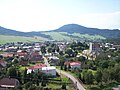 The village streets and surrounding mountains, Church of St. Sophia to the right
 -
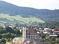
 Church of St. Sophia (August 2011)
 -
 Church of St. Sophia (July 2008)
 -
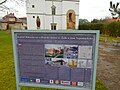 Information sign on the history of the Church of St. Sophia and the Rákóczi family manor house (November 2017)
 -
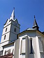
 Church of Saint Margaret of Antioch (August 2011)
 -
 Church of Saint Margaret of Antioch (August 2011)
 -
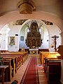 Interior of the Church of Saint Margaret of Antioch (August 2011)
 -
 Chapel of Saint Anne in the village (August 2011)
 -
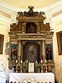 Altar in the Chapel of Saint Anne (August 2011)
 -
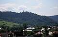 View of the castle hill and Zborov Castle from the village (August 2011)
 -
 Memorial of the World War I eastern frontline in the village (August 2011)
 -
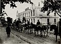 Artillery hauling through the damaged streets of the village during WWI (1915)
 -
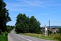 Main road next to the village and village welcome sign (August 2011)


See also
References
External links
 Media related to Zborov, Bardejov District at Wikimedia Commons
- Official website
 (in Slovak)
 - https://web.archive.org/web/20071116010355/http://www.statistics.sk/mosmis/eng/run.html
- Article and gallery on WWI Military Cemetery in Zborov (in Slovak)
- v
- t
- e
Municipalities of Bardejov District
- Abrahámovce
- Andrejová
- Bartošovce
- Becherov
- Beloveža
- Bogliarka
- Brezov
- Brezovka
- Buclovany
- Cigeľka
- Dubinné
- Frička
- Fričkovce
- Gaboltov
- Gerlachov
- Hankovce
- Harhaj
- Hažlín
- Hertník
- Hervartov
- Hrabovec
- Hrabské
- Hutka
- Chmeľová
- Janovce
- Jedlinka
- Kľušov
- Kobyly
- Kochanovce
- Komárov
- Koprivnica
- Kožany
- Krivé
- Kríže
- Kružlov
- Kučín
- Kurima
- Kurov
- Lascov
- Lenartov
- Lipová
- Livov
- Livovská Huta
- Lopúchov
- Lukavica
- Lukov
- Malcov
- Marhaň
- Mikulášová
- Mokroluh
- Nemcovce
- Nižná Polianka
- Nižná Voľa
- Nižný Tvarožec
- Oľšavce
- Ondavka
- Ortuťová
- Osikov
- Petrová
- Poliakovce
- Porúbka
- Raslavice
- Regetovka
- Rešov
- Richvald
- Rokytov
- Smilno
- Snakov
- Stebnícka Huta
- Stebník
- Stuľany
- Sveržov
- Šarišské Čierne
- Šašová
- Šiba
- Tarnov
- Tročany
- Vaniškovce
- Varadka
- Vyšná Polianka
- Vyšná Voľa
- Vyšný Kručov
- Vyšný Tvarožec
- Zborov
- Zlaté

Authority control databases | |
|---|---|
| International |
|
| National |
|
 | This Prešov Region geography article is a stub. You can help Wikipedia by expanding it. |
- v
- t
- e


