Wrinkly Face Provincial Park
Canadian provincial park
50°2′24″N 119°18′38″W / 50.04000°N 119.31056°W / 50.04000; -119.31056Wrinkly Face Provincial Park is a provincial park 16 kilometres north of Winfield in British Columbia, Canada.[2]
History
The park was established on May 20, 2004.
Geography
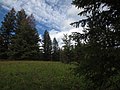
The park is 43 hectares in size. It encompasses a southern-facing cliff along with a series of dry meadows above the cliff and wetter meadows below. The cliff edge provides views of Okanagan Lake and the land toward Kelowna. The High Rim Trail passes through the park along the upper edge of the cliff.
Conservation
The primary role of Wrinkly Face Park is to protect the series of dry meadows at the top of the cliff and the wetter meadows at its base, along with the interior Douglas fir forest. The dry, seasonally-wet, diverse meadows are extremely fragile. Five red/blue-listed vascular plants are known to occur including red-listed Obscure Cryptantha (Cryptantha ambigua) and Needleleaved Navarretia (Navarretia intertexta) and blue-listed Northern Linanthus (Linanthus septentrionalis), False-mermaid (Floerkea proserpinacoides) and Awned Cyperus (Cyperus squarrosus).[3]
Recreation
Wrinkly Face Park provides low-impact recreational opportunities, such as hiking or horseback riding, for nature study and contains part of the regionally-significant 50 km long High Rim Trail.
Rock climbing is also possible here, with upwards of 21 established climbs on basalt cliffs.
Images
Wikimedia Commons has media related to Wrinkly Face Provincial Park.
-
 Spruce Grove
 -
 Summer Wildflowers
 -
 Southern Boundary Signs
 - Wildflowers Video Clip


See also
External links
- Rock climbing route info at RockClimbing.com
References
- v
- t
- e
 | This Okanagan-related article is a stub. You can help Wikipedia by expanding it. |
- v
- t
- e


