Woudsend
Village in Friesland, Netherlands
Woudsend Wâldsein | |
|---|---|
Village | |
 | |
 Flag  Coat of arms | |
 Location in the former Wymbritseradiel municipality | |
52°56′34″N 5°37′39″E / 52.94278°N 5.62750°E / 52.94278; 5.62750 | |
| Country |  Netherlands Netherlands |
| Province |  Friesland Friesland |
| Municipality |  Súdwest-Fryslân Súdwest-Fryslân |
| Area | |
| • Total | 1.30 km2 (0.50 sq mi) |
| Elevation | 0.2 m (0.7 ft) |
| Population (2021)[1] | |
| • Total | 1,380 |
| • Density | 1,100/km2 (2,700/sq mi) |
| Postal code | 8551[1] |
| Dialing code | 0514 |
Woudsend (West Frisian: Wâldsein) is a village in Súdwest-Fryslân in the province of Friesland, the Netherlands. It had a population of around 1,380 in January 2017.[3]
There are two windmills in the village, 't Lam and De Jager.[4]
History
The village was first mentioned in 1337 as Woldesende, and means "end (edge) of the wood".[5] Woudsend is a village from the Middle Ages that developed along the Ee [nl] river. The economy was mainly based on trade and shipping. The village was densely settled and is characterised by many narrow alleys.[6]
The Dutch Reformed church was built in 1660 as a replacement of the medieval church. The new church was not well founded and started to subside. In 1835, it was decided to build a new church on the other side of the village. The church was completed in 1837.[7][4] The Catholic St Michael Church was built in 1792 as a clandestine church behind a residential house. In 1933, a tower was added and the church was enlarged.[4] In 1722, a clandestine Mennonite church was built. It was rebuilt in 1858, but sold in 1968 and now serves as a pub.[4]
The village used to be located on the eastern side of the Ee river. During the 19th century, it was extended to the western side of the river.[4] Woudsend was home to 1,181 people in 1840.[7] Before 2011, the village was part of the Wymbritseradiel municipality.[7]
Gallery
-
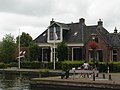 House in Woudsend
 -
 House in Woudsend
 -
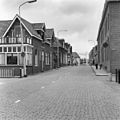 Street view
 -
 Alley in Woudsend


References
- ^ a b c "Kerncijfers wijken en buurten 2021". Central Bureau of Statistics. Retrieved 7 April 2022.
- ^ "Postcodetool for 8551MA". Actueel Hoogtebestand Nederland (in Dutch). Het Waterschapshuis. Retrieved 7 April 2022.
- ^ Kerncijfers wijken en buurten 2017 - CBS Statline
- ^ a b c d e "Woudsend". Friesland wonderland (in Dutch). Retrieved 7 April 2022.
- ^ "Woudsend - (geografische naam)". Etymologiebank (in Dutch). Retrieved 7 April 2022.
- ^ Ronald Stenvert & Sabine Broekhoven (2000). "Woudsend" (in Dutch). Zwolle: Waanders. ISBN 90 400 9476 4. Retrieved 7 April 2022.
- ^ a b c "Woudsend". Plaatsengids (in Dutch). Retrieved 7 April 2022.
External links
![]() Media related to Woudsend at Wikimedia Commons
Media related to Woudsend at Wikimedia Commons
- v
- t
- e
Populated places in the municipality of Súdwest-Fryslân
- Abbegea
- Allingawier
- Arum
- Blauwhuis
- Boazum
- Breezanddijk
- Britswert
- Burgwerd
- Cornwerd
- Dearsum
- Dedgum
- Easterein
- Easterwierrum
- Exmorra
- Ferwoude
- Folsgare
- Gaast
- Gaastmeer
- Gauw
- Goënga
- Greonterp
- Hartwerd
- Heeg
- Hemelum
- Hichtum
- Hidaard
- Hieslum
- Hinnaard
- Hommerts
- Idsegahuizum
- Idzega
- Iens
- Indijk
- It Heidenskip
- Itens
- Jutrijp
- Kimswerd
- Kornwerderzand
- Koudum
- Koufurderrige
- Kûbaard
- Lollum
- Longerhouw
- Lytsewierrum
- Makkum
- Molkwerum
- Nijhuizum
- Nijland
- Oosthem
- Oppenhuizen
- Oudega
- Parrega
- Piaam
- Pingjum
- Poppenwier
- Reahûs
- Raerd
- Rien
- Sandfirden
- Scharl
- Scharnegoutum
- Schettens
- Schraard
- Sibrandabuorren
- Smallebrugge
- Tersoal
- Tirns
- Tjalhuizum
- Tjerkwerd
- Uitwellingerga
- Waaksens
- Warns
- Westhem
- Witmarsum
- Wiuwert
- Wolsum
- Wommels
- Wons
- Woudsend
- Ypecolsga
- Ysbrechtum
- Zurich
| Authority control databases |
|
|---|


