Werkhoven
Village in Utrecht, Netherlands

Coat of arms
52°1′26″N 5°14′35″E / 52.02389°N 5.24306°E / 52.02389; 5.24306
(2001)[1]
3985[1]
Werkhoven is a town in the Dutch province of Utrecht. It is a part of the municipality of Bunnik, and lies about 5 km east of Houten. Castle Beverweerd is located on the other side of the river.
Werkhoven used to be a separate municipality. It merged with Bunnik and Odijk in 1964.[3]
History
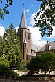
It was first mentioned between 918 and 948 as "UUerken due", and means farms near a meandering river.[4] Werkhoven developed as a stretch out esdorp along the Achter Rijn. A church has existed since the mid-9th century. The current church dates from the 13th century and was extensively modified in 1830.[5] In 1840, Werkhoven was home to 811 people.[3]
Castle Beverweerd was built on the other side of the river, and was first noted in 1274 when Gijsbrecht IV of Amstel, the Count of Holland attacked Utrecht, and the Prince-Bishopric of Utrecht had to flee. The castle was extended and modified multiple times during its history. In 1958, the castle was sold to the Quakers to be used as a school. The school was later renamed Beverweert International School and operated until 1997. In 2004, the castle was squatted. Since 2017, it is owned by a real estate company.[6]
The grist mill Rijn en Weert was built in 1882. It was a replacement of the wind mill at the castle where a wind mill had been known to exist since 1395. In 1921, an electro motor was installed and the wind mill was reduced to its base. In 1993, the wind mill was restored and returned to active service in 1994.[7]
Born in Werkhoven
- Coby van Baalen (*1957), Dutch equestrian.
- Andreas Everardus van Braam Houckgeest (1739–1801), Dutch merchant and diplomat.
- John Oostrom, (born September 2, 1930), a former business executive and Canadian parliamentarian. He was the first Dutch-born Canadian elected to the Canadian House of Commons
Pictures
-
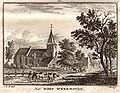 Werkhoven in an engraving by Hendrik Spilman, 1773
 -
 Castle Beverweerd
 -
 Village church
 -
 Catholic church
 -
 De Brink
 -
 Werkhoven ca. 1865
 -
 Skyline Werkhoven, 2008
 -
 Watertower


References
- ^ a b c "Kerncijfers wijken en buurten 2021". Central Bureau of Statistics. Retrieved 28 March 2022.
two entries
- ^ "Postcodetool for 3985AA". Actueel Hoogtebestand Nederland (in Dutch). Het Waterschapshuis. Retrieved 28 March 2022.
- ^ a b "Werkhoven". Plaatsengids (in Dutch). Retrieved 28 March 2022.
- ^ "Werkhoven - (geografische naam)". Etymologiebank (in Dutch). Retrieved 28 March 2022.
- ^ Ronald Stenvert & Chris Kolman (1996). "Werkhoven" (in Dutch). Zwolle: Waanders. ISBN 90 400 9757 7. Retrieved 28 March 2022.
- ^ "Beverweerd". Kastelen in Utrecht (in Dutch). Retrieved 28 March 2022.
- ^ "Rijn en Weert". Molendatabase (in Dutch). Retrieved 28 March 2022.
External links
 Media related to Werkhoven at Wikimedia Commons
| Authority control databases: Geographic |
|
|---|


