Volcán de Colima
Volcano in Mexico


Volcán de Colima
Location in Mexico

The Volcán de Colima, 3,820 m (12,530 ft), also known as Volcán de Fuego, is part of the Colima Volcanic Complex (CVC) consisting of Volcán de Colima, Nevado de Colima (Spanish pronunciation: [neˈβaðo ðe koˈlima] ⓘ)[3] and the eroded El Cántaro (listed as extinct). It is the youngest of the three and as of 2015 is one of the most active volcanoes in Mexico and in North America. It has erupted more than 40 times since 1576. One of the largest eruptions was on January 20–24, 1913.[4] Nevado de Colima, also known as Tzapotépetl, lies 5 kilometres (3.1 mi) north of its more active neighbor and is the taller of the two at 4,271 meters (14,012 feet). It is the 26th-most prominent peak in North America.[5]
Despite its name, only a fraction of the volcano's surface area is in the state of Colima; the majority of its surface area lies over the border in the neighboring state of Jalisco, toward the western end of the Trans-Mexican Volcanic Belt. It is about 485 km (301 mi) west of Mexico City and 125 km (78 mi) south of Guadalajara, Jalisco.
Since 1869–1878, a parasitic set of domes, collectively known as El Volcancito, has formed on the northeast flank of the main cone of the volcano.[6]
Geological history
In the late Pleistocene era, a huge landslide occurred at the mountain, with approximately 25 km3 (6.0 cu mi) of debris traveling some 120 km, reaching the Pacific Ocean. An area of some 2,200 km2 was covered in landslide deposits. The currently active cone is within a large caldera that was probably formed by a combination of landslides and large eruptions. The lava is andesite containing 56-61% SiO2.[7] About 300,000 people live within 40 km (25 mi) of the volcano, which makes it the most dangerous volcano in Mexico.[4] In light of its history of large eruptions and situation in a densely populated area, it was designated a Decade Volcano, singling it out for study.
Current activity
In recent years, there have been frequent temporary evacuations of nearby villagers due to threatening volcanic activity. Eruptions have occurred in 1991, 1998–1999 and from 2001 to the present day, with activity being characterized by extrusion of viscous lava forming a lava dome, and occasional larger explosions, forming pyroclastic flows and dusting the areas surrounding the volcano with ash and tephra.
The largest eruption for several years occurred on May 24, 2005. An ash cloud rose to more than 3 km over the volcano and satellite monitoring indicated that the cloud spread over an area extending 110 nautical miles (200 km) west of the volcano in the hours after the eruption.[8] Pyroclastic flows travelled 4–5 km from the vent, and lava bombs landed 3–4 km away. Authorities set up an exclusion zone within 6.5 km of the summit.
On November 21, 2014, the volcano erupted again. An ash column was sent 5 km into the air, covering towns as far as 25 km away in ash. No fatalities were reported, and no evacuations took place.[citation needed] There were eruptions on January 10, 21 and 25, with the ash from the January 21 eruption falling in towns more than 15 miles (24 km) away.[9][10]
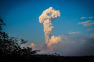
On 10 July 2015, there was another eruption. Another eruption occurred on September 25, 2016, sending a plume of ash and smoke 10,000 feet (3,000 m) into the sky. During December 2016, ash plumes occurred once or twice a day. On December 18, 2016, there were three eruptions. The biggest columns of ash reached 2 kilometers in height.[11]
Colima volcano experienced another strong explosion at 06:27 UTC (00:27 CST) on January 18, 2017. The eruption spewed volcanic ash up to 4 km (13,123 feet) above the crater.
Volcanological center
The volcano is monitored by the Colima Volcano Observatory at the University of Colima, Mexico. A team analyzes, interprets and communicates every event that occurs at this volcano.
In 2018, a webcam was installed close to the volcano, and volcanic activity can be seen in real-time.[12]
References
- Notes
- ^ a b c "Volcán de Colima, Mexico". Peakbagger.com.
- ^ "Colima volcano". 19 Feb 2018.
- ^ "The Colima Volcanic Complex, Mexico" (PDF). Mineralogy and Petrology. Retrieved 2012-05-04.
- ^ a b Ritchie, David (2006). Encyclopedia of Earthquakes and Volcanoes. Alexander E. Gates, Ph.D., and David Ritchie. p. 52.
- ^ "North America Peaks with 2000 meters of Prominence". Peakbagger.com. Retrieved 2012-05-03.
- ^ "Structure of the Volcancito Dome, Volcan Fuego De Colima, Mexico, Revealed in High Resolution Magnetic Anomalies". confex.com. Archived from the original on 2009-02-23. Retrieved 2006-07-23.
- ^ http://www.geo.mtu.edu/EHaz/ConvergentPlatesClass/Colima/Luhr%20Colima%20andesite.pdf James F. Luhr and Ian S.E. Carmichael, 1980: The Colima Volcanic Complex, Mexico in Contributions to Mineralogy and Petrology, Vol. 71, page 347
- ^ http://www.ssd.noaa.gov/VAAC/ARCHIVE/COLI/2005E240658.html[dead link]
- ^ "VIDEO: Mexico's Colima Volcano spews enormous cloud of ash". NY Daily News. 22 January 2015.
- ^ "Footage of huge ash plume as Mexico's Colima volcano erupts". BBC News. 25 January 2015. Retrieved 27 January 2015.
- ^ "Mexico's Colima Volcano Spews Ash, Vapor a Mile Into the Air". New York Times. December 18, 2016. Retrieved December 18, 2016.
- ^ "Volcán de Colima". www.webcamsdemexico.com. Retrieved 2018-12-26.
- Bibliography
- Domínguez T., Ramírez J.J., Breton M. (2003), Present Stage Of Activity At Colima Volcano, Mexico, American Geophysical Union, Fall Meeting 2003, abstract #V42B-0350
External links
Volcán de Colima at Wikipedia's sister projects
 Definitions from Wiktionary
 Media from Commons
 News from Wikinews
 Quotations from Wikiquote
 Texts from Wikisource
 Textbooks from Wikibooks
 Resources from Wikiversity
- Universidad de Colima, Observatorio Vulcanológico (in Spanish)
- Universidad de Colima, Centro de Intercambio e Investigación en Vulcanología (in English and Spanish)
- Experiments at Colima by the Alaska Volcano Observatory
- "Colima". Global Volcanism Program. Smithsonian Institution. Retrieved 2009-01-14.
- "Volcán de Colima". SummitPost.org. Retrieved 2016-12-03.
- v
- t
- e
- Denali
- Mount Logan
- Pico de Orizaba
- Mount Saint Elias
- Volcán Popocatépetl
- Mount Foraker
- Mount Lucania
- Volcán Iztaccíhuatl
- King Peak
- Mount Bona
- Mount Steele
- Mount Blackburn
- Mount Sanford
- Mount Wood
- Mount Vancouver
- Mount Slaggard
- Nevado de Toluca
- Mount Fairweather
- Sierra Negra
- Mount Hubbard
- Mount Bear
- Mount Walsh
- Mount Hunter
- Volcán La Malinche
- Mount Whitney
- Mount Alverstone
- University Peak
- Mount Elbert
- Mount Massive
- Mount Harvard
- Mount Rainier
- Mount Williamson
- McArthur Peak
- Blanca Peak
- La Plata Peak
- Uncompahgre Peak
- Crestone Peak
- Mount Lincoln
- Castle Peak
- Grays Peak
- Mount Antero
- Mount Blue Sky
- Longs Peak
- Mount Wilson
- White Mountain Peak
- North Palisade
- Mount Princeton
- Mount Yale
- Mount Shasta
- Maroon Peak
- Mount Wrangell
- Mount Sneffels
- Capitol Peak
- Pikes Peak
- Windom Peak/Mount Eolus
- Mount Augusta
- Handies Peak
- Culebra Peak
- Cofre de Perote
- San Luis Peak
- Mount of the Holy Cross
- Nevado de Colima
- Grizzly Peak
- Mount Humphreys
- Mount Keith
- Mount Strickland
- Mount Ouray
- Vermilion Peak
- Avalanche Peak
- Atna Peaks
- Volcán Tajumulco
- Regal Mountain
- Mount Darwin
- Mount Hayes
- Mount Silverheels
- Rio Grande Pyramid
- Gannett Peak
- Mount Kaweah
- Grand Teton
- Mount Cook
- Mount Morgan
- Mount Gabb
- Bald Mountain
- Mount Oso
- Mount Jackson
- Mount Tom
- Bard Peak
- Cerro Tláloc
- West Spanish Peak
- Mount Powell
- Hagues Peak
- Mount Dubois
- Tower Mountain
- Treasure Mountain
- Kings Peak
- North Arapaho Peak
- Mount Pinchot
- Mount Natazhat
- Mount Jarvis
- Parry Peak
- Bill Williams Peak
- Sultan Mountain
- Mount Herard
- Volcán Tacaná
- West Buffalo Peak
- Mount Craig
- Tressider Peak
- Summit Peak
- Middle Peak/Dolores Peak
- Antora Peak
- Henry Mountain
- Hesperus Mountain
- Mount Silverthrone
- Jacque Peak
- Bennett Peak
- Wind River Peak
- Mount Waddington
- Conejos Peak
- Mount Marcus Baker
- Cloud Peak
- Wheeler Peak
- Francs Peak
- Twilight Peak
- South River Peak
- Mount Ritter
- Red Slate Mountain


Authority control databases | |
|---|---|
| International |
|
| National |
|
| Geographic |
|


