Volcán Isluga National Park
National park in Chile
19°09′00″S 68°50′00″W / 19.15000001°S 68.8333333433°W / -19.15000001; -68.8333333433
Volcán Isluga National Park (Spanish pronunciation: [isˈluɣa]) is in the Andes, in the Tarapacá Region of Chile, near Colchane and south of Lauca Biosphere Reserve. It covers 1,747 square kilometres (675 sq mi), with elevations ranging between 2,100 and 5,550 metres (6,890 and 18,210 ft).[1] It is named after Volcán Isluga, which at 5,550 m, is the tallest mountain in this park.
Peaks
There are numerous peaks in the national park. The most prominent include the Qinsachata Hill (5400 m), Tatajachura Hill (5252 m), the Isluga Volcano (5218 m) and the Catarama (5207 m).[2]
Flora
The park has the usual flora that grows at high altitudes. Numerous species of cacti and queñoas are native to the park.[2]
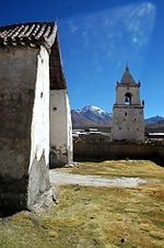
The park includes cultural heritage of the Aymara people. There are several ceremonial towns within the park, such as Isluga.
References
- (in Spanish) Parque Nacional Volcán Isluga
- ^ "Isluga Volcano National Park". VisitChile. Retrieved 12 July 2013.
- ^ a b "Isluga Volcano National Park". VisitChile Reps. Retrieved 12 July 2013.
- v
- t
- e
- Alberto de Agostini
- Alerce Andino
- Alerce Costero
- Archipiélago de Juan Fernández
- Bernardo O'Higgins
- Bosque de Fray Jorge
- Cabo de Hornos
- Cerro Castillo
- Chiloé
- Conguillío
- Corcovado
- Hornopirén
- Huerquehue
- Isla Guamblin
- Isla Magdalena
- Kawésqar
- La Campana
- Laguna del Laja
- Laguna San Rafael
- Las Palmas de Cocalán
- Lauca
- Llanos de Challes
- Llullaillaco
- Melimoyu
- Morro Moreno
- Nahuelbuta
- Nevado Tres Cruces
- Nonguén
- Pali Aike
- Pan de Azúcar
- Patagonia
- Pumalín Douglas Tompkins
- Puyehue
- Queulat
- Radal Siete Tazas
- Rapa Nui
- Salar del Huasco
- Tolhuaca
- Torres del Paine
- Vicente Pérez Rosales
- Villarrica
- Volcán Isluga
- Yendegaia
 | This Tarapacá Region location article is a stub. You can help Wikipedia by expanding it. |
- v
- t
- e
 | This article related to a protected area in South America is a stub. You can help Wikipedia by expanding it. |
- v
- t
- e


