Villa Santa Lucia degli Abruzzi
Comune in Abruzzo, Italy

Coat of arms
Location of Villa Santa Lucia degli Abruzzi

42°20′3″N 13°46′40″E / 42.33417°N 13.77778°E / 42.33417; 13.77778
(1 January 2007)[2]
67020
Villa Santa Lucia degli Abruzzi is a little comune and town in the province of L'Aquila in the Abruzzo region of Italy. It is located in the Gran Sasso e Monti della Laga National Park.
Twin town
 Port Colborne, Canada

References
External links
- Villa Pro-loco association site
- Carrufo Pro-Loco association site
Gallery
-
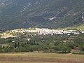 Panorama of V.S.L.dA.
 -
 Cats of Carrufo
 -
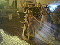 Dancing of the pupa 1
 -
 Dancing of the pupa 2
 -
 Dancing of the pupa 3


- v
- t
- e
- Acciano
- Aielli
- Alfedena
- Anversa degli Abruzzi
- Ateleta
- Avezzano
- Balsorano
- Barete
- Barisciano
- Barrea
- Bisegna
- Bugnara
- Cagnano Amiterno
- Calascio
- Campo di Giove
- Campotosto
- Canistro
- Cansano
- Capestrano
- Capistrello
- Capitignano
- Caporciano
- Cappadocia
- Carapelle Calvisio
- Carsoli
- Castel del Monte
- Castel di Ieri
- Castel di Sangro
- Castellafiume
- Castelvecchio Calvisio
- Castelvecchio Subequo
- Celano
- Cerchio
- Civita d'Antino
- Civitella Alfedena
- Civitella Roveto
- Cocullo
- Collarmele
- Collelongo
- Collepietro
- Corfinio
- Fagnano Alto
- Fontecchio
- Fossa
- Gagliano Aterno
- Gioia dei Marsi
- Goriano Sicoli
- Introdacqua
- L'Aquila
- Lecce nei Marsi
- Luco dei Marsi
- Lucoli
- Magliano de' Marsi
- Massa d'Albe
- Molina Aterno
- Montereale
- Morino
- Navelli
- Ocre
- Ofena
- Opi
- Oricola
- Ortona dei Marsi
- Ortucchio
- Ovindoli
- Pacentro
- Pereto
- Pescasseroli
- Pescina
- Pescocostanzo
- Pettorano sul Gizio
- Pizzoli
- Poggio Picenze
- Prata d'Ansidonia
- Pratola Peligna
- Prezza
- Raiano
- Rivisondoli
- Rocca Pia
- Rocca di Botte
- Rocca di Cambio
- Rocca di Mezzo
- Roccacasale
- Roccaraso
- San Benedetto dei Marsi
- San Benedetto in Perillis
- San Demetrio ne' Vestini
- San Pio delle Camere
- San Vincenzo Valle Roveto
- Sant'Eusanio Forconese
- Sante Marie
- Santo Stefano di Sessanio
- Scanno
- Scontrone
- Scoppito
- Scurcola Marsicana
- Secinaro
- Sulmona
- Tagliacozzo
- Tione degli Abruzzi
- Tornimparte
- Trasacco
- Villa Sant'Angelo
- Villa Santa Lucia degli Abruzzi
- Villalago
- Villavallelonga
- Villetta Barrea
- Vittorito
 | This Abruzzo location article is a stub. You can help Wikipedia by expanding it. |
- v
- t
- e


