Veendam
Town and Municipality in Groningen, Netherlands

Flag

Coat of arms

Location in Groningen
(January 2021)[4]
9630–9633, 9640–9648
Veendam (Dutch pronunciation: [veːnˈdɑm] ⓘ) is a town and municipality with a population of 27,752 in the province of Groningen in the northeast of the Netherlands. Veendam was established in 1648 as a peat colony by Adriaan Geerts Wildervanck.[5]
Holland America Line has named four ships Veendam after the town.
The municipality includes Westerdiepsterdallen, the smallest town in the Netherlands.
Geography
The population centres in the municipality are:
- Bareveld
- Borgercompagnie
- Kibbelgaarn
- Korte Akkers
- Numero Dertien
- Ommelanderwijk
- Tripscompagnie
- Veendam
- Wildervank
- Wildervanksterdallen
- Zuidwending
International relations
Veendam has two sister cities:


Sports
Cycling
Veendam was the start place of stage 4b at the 2012 Energiewacht Tour and the finish place of stage 2 at the 2013 Energiewacht Tour.
Sport clubs
- SC Veendam, former soccer club[7]
- Flash Veendam, volleyball club[8]
- NNZC Veendam, gliding club[9]
Notable residents
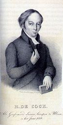

- Hendrik de Cock (1801–1842) a Dutch minister responsible for the 1834 Dutch Reformed Church split
- Anthony Winkler Prins (1817 in Voorst – 1908) a Dutch writer, chief editor of the Winkler Prins encyclopedia.
- Herman Mees (1880–1964) was a Dutch artist, portrait painter, watercolorist and academic
- Herman Johannes Lam (1892–1977) a Dutch botanist
- Addeke Hendrik Boerma (1912–1992) the first Executive Director of the World Food Programme 1962-1967
- Gerda Geertens (born 1955 in Wildervank) a Dutch composer
Sport
- Bert Romp (1958–2018) a Dutch equestrian, gold medallist at the 1992 Summer Olympics
- Janette Bouman (born 1964) a Dutch-born Kazakhstani dressage rider
- Rick Slor (born 1971) a retired professional footballer with 509 club caps
- Anneke Venema (born 1971) a retired rower, silver medallist at the 2000 Summer Olympics
- Linda Moes (born 1971) a former breaststroke swimmer, competed at the 1988 Summer Olympics
- Peter Windt (born 1973) a Dutch former field hockey player
- Renate Groenewold (born 1976) a Dutch former long track speed skater, silver medallist at both the 2002 and the 2006 Winter Olympics
- Henk Grol (born 1985 in Winschoten) a Dutch judoka, bronze medallist at both the 2008 and the 2012 Summer Olympics
- Jeroen Zoet (born 1991) a Dutch professional football goalkeeper with over 250 club caps
Topography

References
- ^ "Burgemeester" [Mayor] (in Dutch). Gemeente Veendam. Retrieved 5 February 2014.
- ^ "Kerncijfers wijken en buurten 2020" [Key figures for neighbourhoods 2020]. StatLine (in Dutch). CBS. 24 July 2020. Retrieved 19 September 2020.
- ^ "Postcodetool for 9641AW". Actueel Hoogtebestand Nederland (in Dutch). Het Waterschapshuis. Retrieved 5 February 2014.
- ^ "Bevolkingsontwikkeling; regio per maand" [Population growth; regions per month]. CBS Statline (in Dutch). CBS. 1 January 2021. Retrieved 2 January 2022.
- ^ "Veendam". Plaatsengids (in Dutch). Retrieved 27 February 2022.
- ^ a b "Zustersteden". Veendam. Retrieved 3 May 2014.
- ^ SC Veendam - Soccer club
- ^ Flash Veendam - Volleyball club
- ^ NNZC Veendam - Gliding club
External links
Wikimedia Commons has media related to Veendam.
- Official website

Places adjacent to Veendam | ||||||||||||||||
|---|---|---|---|---|---|---|---|---|---|---|---|---|---|---|---|---|
| ||||||||||||||||


- v
- t
- e
Populated places in the municipality of Veendam
- Veendam
- Bareveld
- Borgercompagnie
- Ommelanderwijk [nl]
- Tripscompagnie [nl]
- Wildervank
Municipalities of Groningen | ||
|---|---|---|
|  | |
| ||
Authority control databases | |
|---|---|
| International |
|
| National |
|
| Geographic |
|
 | This Groningen location article is a stub. You can help Wikipedia by expanding it. |
- v
- t
- e


