Tull en 't Waal
Village in Utrecht, Netherlands
52°0′2″N 5°7′59″E / 52.00056°N 5.13306°E / 52.00056; 5.13306 (2021)[1]
3999[1]
Tull en 't Waal is a village in the Dutch province of Utrecht. Until 1962, it was a separate municipality, but now it is a part of the municipality of Houten. Originally, there were two villages: 't Waal, at the site of the present village; and Tull, more to the south. It also has a ferry connection to the town of Culemborg.[3] It is located close to the Lek River.[4]
History
Tull is first mentioned in 1155 as "in loco qui dicitur Tylle". The etymology is unclear.[5] 't Waal was first mentioned in 1307 as Wale, and means "pool after a dike breach". In 1504, the hamlets are first mentioned as Tul ende tWael.[6] The village is a 12th century peat excavation project along the Waalsewetering. The church is a medieval building which was extensively modified in 1778 and 1890.[7] The hamlet Honswijk [nl] used to be part of the village, but was transferred to Schalkwijk. In 1840, Tull en 't Waal was home to 532 people.[4]
Werk aan de Waalse Wetering is a military fortification as part of the Dutch Water Line. It was constructed in 1815, and has bomb proof barracks.[8] The fort became obsolete after the investion of the air plane. It was later used by the Nederlandse Spoorwegen to store bridging material. In 1999, it was converted into a tea house and camping.[4]
Gallery
-
 Protestant Church
 -
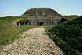 Barracks of the Waalse Wetering
 -
 Fort watchman house
 -
 Street view


References
- ^ a b c "Kerncijfers wijken en buurten 2021". Central Bureau of Statistics. Retrieved 28 March 2022.
two entries
- ^ "Postcodetool for 3999NK". Actueel Hoogtebestand Nederland (in Dutch). Het Waterschapshuis. Retrieved 28 March 2022.
- ^ "Veerverbinding over de Lek". Oud Houten (in Dutch). Retrieved 28 March 2022.
- ^ a b c "Tull en 't Waal". Plaatsengids (in Dutch). Retrieved 28 March 2022.
- ^ "Tull - (geografische naam)". Etymologiebank (in Dutch). Retrieved 28 March 2022.
Authenticity of earlier references is in doubt
- ^ "'t Waal - (geografische naam)". Etymologiebank (in Dutch). Retrieved 28 March 2022.
- ^ Ronald Stenvert & Chris Kolman (1996). "Tull en 't Waal" (in Dutch). Zwolle: Waanders. ISBN 90 400 9757 7. Retrieved 28 March 2022.
- ^ "Monumentnummer: 531597 te Houten". Dutch Monument Register (in Dutch). Retrieved 28 March 2022.
- v
- t
- e
Populated places in the municipality of Houten
- 't Goy
- Schalkwijk
- Tull en 't Waal
| Authority control databases |
|
|---|


