Squirrel Point Light
Lighthouse in Maine, US
Lighthouse
43°48′59.483″N 69°48′8.572″W / 43.81652306°N 69.80238111°W / 43.81652306; -69.80238111Red 7 nautical miles (13 km; 8.1 mi)
Squirrel Point Light Station
Squirrel Point Light is a lighthouse marking the southwestern point of Arrowsic Island on the Kennebec River.[2][3][4] It was established in 1898, as part of a major upgrade of the river's lights — the Doubling Point Light and the separate Range Lights on the point, Perkins Island Light, and Squirrel Point Light were all built at the same time. The light station was listed on the National Register of Historic Places as Squirrel Point Light Station on January 21, 1988.[1]
Description and history
Arrowsic Island is a large island on the Mid Coast of Maine, bounded by a number of tidal rivers. The main one, the Kennebec River, is on the west side of the island, flowing south from the major port and shipbuilding city of Bath to the Gulf of Maine. Squirrel Point is the southwestern tip of the island. The light station at Squirrel Point includes a tower, keeper's house, barn, boathouse, and oil house. The tower is an octagonal wood-frame structure, with the lantern house topped by a ventilator and surrounded by an iron railing and wooden bracketed gallery. A gabled sound signal chamber is attached to one side. The keeper's house is a two-story wood-frame structure with a cross-gable roof.[5]
The United States Congress authorized improvements to the aids to navigation on the Kennebec River in 1895, and this station was built under that authorization in 1898. The oil house was added in 1906, and the station was automated in 1982.[5]
Gallery
-
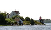
 Squirrel Point Light with keeper's quarters
 -
 From upriver
 -
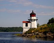 From downriver
 -
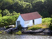 The boathouse — The ridge is parallel to the ground, but the ends and the window are vertical
 -
 Daytime Squirrel Point Light with light on


See also
Wikimedia Commons has media related to Squirrel Point Light.
References
- ^ a b "National Register Information System". National Register of Historic Places. National Park Service. March 13, 2009.
- ^ "Historic Light Station Information and Photography: Maine". United States Coast Guard Historian's Office. Archived from the original on May 1, 2017.
- ^ Light List, Volume I, Atlantic Coast, St. Croix River, Maine to Shrewsbury River, New Jersey (PDF). Light List. United States Coast Guard. 2009. p. 52.
- ^ Rowlett, Russ (October 9, 2009). "Lighthouses of the United States: Southern Maine". The Lighthouse Directory. University of North Carolina at Chapel Hill.
- ^ a b Kirk Mohney (1977). "NRHP nomination for Squirrel Point Light Station". National Park Service. Retrieved June 17, 2016. with photos from 1987
- v
- t
- e
Lighthouses of Maine
- Avery Rock Light
- Baker Island Light
- Bass Harbor Head Light
- Bear Island Light
- Blue Hill Bay Light
- Boon Island Light
- Browns Head Light
- Burnt Coat Harbor Light
- Burnt Island Light
- Cape Elizabeth Lights
- Cape Neddick Light
- Crabtree Ledge Light
- The Cuckolds Light
- Curtis Island Light
- Deer Isle Thorofare Light
- Dice Head Light
- Doubling Point Light
- Doubling Point Range Lights
- Eagle Island Light
- Egg Rock Light
- Fiddler's Reach Fog Signal
- Fort Point Light
- Franklin Island Light
- Goat Island Light
- Goose Rocks Light
- Great Duck Island Light
- Grindel Point Light
- Halfway Rock Light
- Hendricks Head Light
- Heron Neck Light
- Indian Island Light
- Isle au Haut Light
- Ladies Delight Light
- Libby Island Light
- Little River Light
- Lubec Channel Light
- Machias Seal Island*
- Marshall Point Light
- Matinicus Rock Light
- Monhegan Island Light
- Moose Peak Light
- Mount Desert Light
- Narraguagus Light
- Nash Island Light
- Owls Head Light
- Pemaquid Point Light
- Perkins Island Light
- Petit Manan Light
- Pond Island Light
- Portland Breakwater Light
- Portland Head Light
- Prospect Harbor Point Light
- Pumpkin Island Light
- Ram Island Light
- Ram Island Ledge Light
- Rockland Harbor Breakwater Light
- Saddleback Ledge Light
- Saint Croix River Light
- Seguin Light
- Spring Point Ledge Light
- Squirrel Point Light
- Tenants Harbor Light
- Two Bush Island Light
- West Quoddy Head Light
- Whaleback Light
- Whitehead Light
- Whitlocks Mill Light
- Winter Harbor Light
- Wood Island Light

* Disputed territory claimed by Maine but de facto controlled by Canada
| |
|---|---|
| Topics | |
| Lists by state |
|
| Lists by insular areas | |
| Lists by associated state | |
| Other areas | |
| Related | |
| |


| Authority control databases: Geographic |
|
|---|


