South Baldface
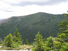
South Baldface is a 3,547-foot (1,081 m) mountain in the town of Chatham, New Hampshire in the eastern White Mountains. It gets its name from its steep barren eastern face. Along with the neighboring summit North Baldface, it is a popular hiking destination, especially in the summer. The two mountains are ascended by the Slippery Brook, Baldface Knob, Baldface Circle, Meader Ridge, and Bicknell Ridge trails.
Nearby mountains and drainage
North Baldface lies directly to the northwest. Eastman Mountain, a partially wooded mountain that is climbed by a .8-mile (1.3 km) trail that diverges from the Slippery Brook Trail, is to the southeast. Sable Mountain and Chandler Mountain, two heavily wooded and trailless summits, are to the southwest.
The northeast and east sides of the mountain drain into the Cold River watershed, a tributary of the Saco River, which flows to the Atlantic Ocean; the west side drains into the East Branch Saco River, thence into the Saco; and the south side drains into Slippery Brook, a tributary of the East Branch of the Saco.
See also
 New Hampshire portal

- Speckled Mountain
External links
- U.S. Geological Survey Geographic Names Information System: South Baldface
- v
- t
- e
- Belknap Mountain
- Gunstock Mountain
- Mount Major
- Mount Rowe
- Bayle Mountain
- Larcom Mountain
- Mount Roberts
- Mount Shaw
- Mount Whittier
- Nickerson Mountain
- Turtleback Mountain
- Barrett Mountain
- Kidder Mountain
- New Ipswich Mountain
- North Pack Monadnock
- Pack Monadnock
- Pratt Mountain
- Temple Mountain
- Blue Job Mountain
- Crotched Mountain
- Gap Mountain
- Little Monadnock Mountain
- Lovewell Mountain
- Moose Mountain
- Mount Assurance
- Mount Cardigan
- Mount Kearsarge
- Mount Kelsey
- Mount Magalloway
- Mount Monadnock
- Mount Sunapee
- Pitcher Mountain
- Potanipo Hill
- Ragged Mountain
- Skatutakee Mountain
- Smarts Mountain
- Tenney Mountain
- Thumb Mountain
- Uncanoonuc Mountains
44°13′50″N 71°04′41″W / 44.23056°N 71.07806°W / 44.23056; -71.07806
 | This New Hampshire state location article is a stub. You can help Wikipedia by expanding it. |
- v
- t
- e


