Slatina v Rožni Dolini
Place in Styria, Slovenia
46°16′53.85″N 15°14′38.75″E / 46.2816250°N 15.2440972°E / 46.2816250; 15.2440972 Slovenia
 (2020)
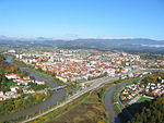
Slatina v Rožni Dolini (pronounced [ˈslaːtina w ˈɾoːʒni dɔˈliːni]; Slovene: Slatina v Rožni dolini) is a settlement in the City Municipality of Celje in eastern Slovenia. It lies on the northern outskirts of Celje. The area is part of the traditional region of Styria. It is now included with the rest of the municipality in the Savinja Statistical Region.[2]
Name
The name of the settlement was changed from Slatina to Slatina v Rožni dolini in 1955.[3]
References
External links
- Slatina v Rožni Dolini on Geopedia
- v
- t
- e
Celje

- Center
- Dečkovo Naselje
- Dolgo Polje
- Gaberje
- Hudinja
- Karel Destovnik Kajuh
- Lava
- Nova Vas
- Savinja
- Slavko Šlander
- Celje Airport
- Celje Castle
- Grmada
- Celje Hall
- Iron Mansion
- Jošt Mill
- Kalvarija
- Celje Lodge
- Lower Celje Castle
- Marian Column
- Minorite Monastery
- National Hall
- Old County
- People's Savings Bank
- Celje Post Office
- Prothasi Mansion
- Slovene National Theatre
- Stari Pisker Prison
- Celje Railway Station
- Celje Town Hall
- Celje town walls
- War and Peace (monument)
- Celje Water Tower
- Aljažev Hrib
- Ljubečna
- Medlog
- Ostrožno
- Pod Gradom
- Škofja Vas
- Šmartno v Rožni Dolini
- Teharje
- Trnovlje
the urban center
- Brezova
- Bukovžlak
- Dobrova
- Glinsko
- Gorica pri Šmartnem
- Jezerce pri Šmartnem
- Košnica pri Celju
- Lahovna
- Leskovec
- Lipovec pri Škofji Vasi
- Ljubečna
- Lοče
- Lokrovec
- Lopata
- Medlog
- Osenca
- Otemna
- Pečovnik
- Pepelno
- Prekorje
- Rožni Vrh
- Runtole
- Rupe
- Šentjungert
- Škofja Vas
- Slance
- Slatina v Rožni Dolini
- Šmarjeta pri Celju
- Šmartno v Rožni Dolini
- Šmiklavž pri Škofji Vasi
- Teharje
- Tremerje
- Trnovlje pri Celju
- Vrhe
- Začret
- Zadobrova
- Žepina
- Zvodno
- Babno
- Breg
- Čret
- Lava
- Lisce
- Ložnica pri Celju
- Miklavžev Hrib
- Nova Vas
- Ostrožno
- Polule
- Spodnja Dobrova
- Spodnja Hudinja
- Spodnji Medlog
- Zagrad
- Zavode
- Zavodna
- Zgornja Hudinja
- Zgornji Medlog
- Emerik Bernard
- Jolanda Čeplak
- Anica Černej
- Romana Jordan Cizelj
- Janez Drnovšek
- Janez Drozg
- Ivan Kovačič Efenka
- Thea Gammelin
- Cvetko Golar
- Damjana Golavšek
- Andrej Hieng
- Stane Jagodič
- Jelko Kacin
- Alma Karlin
- Brane Mihajlovič Kosta
- Janez K. Lapajne
- Janez Lapajne
- Vladimir Levstik
- Darinka Pavletič–Lorenčak
- Stanko Lorger
- Matija Lubanus
- Vita Mavrič
- Drago Medved
- Miloš Mikeln
- Peter Muhič
- Vatroslav Oblak
- Janko Orožen
- Oto Pestner
- Rok Praznik
- Tomaž Prelokar
- Brikcij Preprost
- Franc Purg
- Andreja Rihter
- Fran Roš
- Lojze Rozman
- August Friderik Seebacher
- Josip Tominšek
- Beno Udrih
- Bina Štampe Žmavc
- Urška Žolnir


