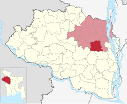
Sherpur Upazila
Upazila in Rajshahi, Bangladesh
Sherpur শেরপুর | |
|---|---|
Upazila | |
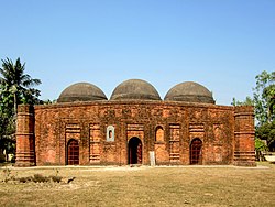 Kherua Mosque | |
 | |
| Coordinates: 24°40′N 89°25′E / 24.667°N 89.417°E / 24.667; 89.417 | |
| Country |  Bangladesh Bangladesh |
| Division | Rajshahi |
| District | Bogra |
| Area | |
| • Total | 295.93 km2 (114.26 sq mi) |
| Population (2011 census)[1] | |
| • Total | 332,825 |
| • Density | 1,100/km2 (2,900/sq mi) |
| Time zone | UTC+6 (BST) |
| Postal code | 5840 to 5842 |
| Website | sherpur |
Sherpur Upazila (Bengali: শেরপুর উপজেলা) is an upazila of Bogra District in the Division of Rajshahi, Bangladesh. Sherpur Thana was established in 1962 and was converted into an upazila in 1983.[2] It is named after its administrative center, the town of Sherpur. It is said that there once lived Sher (Bengali: শের, tiger) family in the vicinity, from which the name "Sherpur" evolved.[citation needed]
History of the War of Liberation
History of the War of Liberation On 25 April 1971 the Pak army abducted 32 innocent people and took them to the Itakhola mass killing site and shot 25 of them dead. On 26 April, they also killed more than three hundred innocent Bangalis at a place near the Ghoga Bridge. On the same day the Pak army brutally tortured to death 26 persons at village Darimukunda. Besides, in May the Pak army killed more than one hundred innocent people at village Kallani. Marks of the War of Liberation Mass killing site 1 (Baghra Colony).
Geography
Sherpur Upazila has a total area of 295.93 square kilometres (114.26 sq mi).[1] It borders Shajahanpur Upazila to the north, Dhunat Upazila to the east, Sirajganj District to the south, Natore District to the south and west, and Nandigram Upazila to the west.[2]
Demographics
| Year | Pop. (000) | ±% |
|---|---|---|
| 1991 | 229 | — |
| 2001 | 286 | +24.9% |
| 2011 | 333 | +16.4% |
| 2022 | 384 | +15.3% |
| Source: Bangladesh Bureau of Statistics[1] | ||
According to the 2011 Bangladesh census, Sherpur Upazila had 81,753 households and a population of 332,825. 68,049 (20.45%) were under 10 years of age. Sherpur had a literacy rate (age 7 and over) of 43.03%, compared to the national average of 51.8%, and a sex ratio of 1011 females per 1000 males. 54,082 (16.25%) lived in urban areas.[1] Ethnic population was 3,603 (1.08%).[3]
Religion
Islam is the dominant religion of Sherpur Upazila. Indigenous community such as santal belongs to this upazila.
There are 461 mosque, 65 temple, and 1 church. Among them noted religious institutions are Kherua Mosque, Dhar Mokam Mosque, and Sher Mokam Mosque.
Tourism
- Kherua Mosque, built in 1582, is an example of early Mughal architecture in Bengal. It is a symmetrical, single-aisled, three-bayed mosque with three domes.[4]
- Bhabanipur Shaktipeeth, one of seven Shakti Peethas in Bangladesh, is a sacred site for the followers of Hinduism.[5] Other famous spots are Bhabanipur Kali Mandir,[2]
- Baghmara Jame Mosque, Baghmara jame mosque is located at Baghmara in Shah-bondegi
- Baghmara Box Vandari Majar Shorif,
- Soudia Park City,
- Sirajnagar Mosque,
- Sher-Shah Mosque,
- Shah-Bandegi Mosque,
- Shah-Turkan Mosque,
- Gobinda Rai Mandir,
- Khasba Village,
- Landscapes of Sherpur Upazila
-
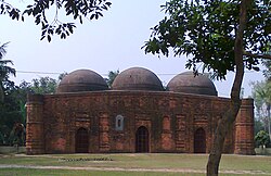 Kherua Mosque is a Mughal architecture
 -
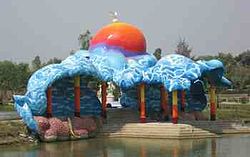 Saudia City Park is an amusement park in Sherpur
 -
 Freedom Fighter's Grave (Mass killing site at Darimokunda)
 -
 Village road in Autumn Season in Sherpur


Economy
Main sources of income Agriculture 61.33%, non-agricultural labourer 2.97%, industry 1.44%, commerce 14.50%, transport and communication 4.47%, service 5.79%, construction 1.88%, religious service 0.16%, rent and remittance 0.27% and others 7.19%. Agricultural land Landowner 50.08%, landless 49.92%; agricultural landowner: urban 31.78% and rural 53.29%.'
Main crops Paddy, wheat, jute, maize, mustard, kalai, betel leaf, potato, onion, vegetables. Main fruits Banana.
Besides, There are Fishery 32, dairy 181, poultry 172, hatchery 1, Manufactories Rice mill 516, Saw mill 44, Flour mill 251, Oil mill 12, Ice factory 10, Cement factory 1, Cold storage 1, Goldsmith 72, Blacksmith 335, Potteries 66, Weaving 460, Embroidery 547, Bamboo and Wood work 675.
Every year they export lot of Paddy, wheat, maize, betel leaf, banana, vegetables.
Administration
Administration Sherpur Thana was formed in 1962 and it was turned into an upazila in 1983. Sherpur Upazila is divided into Sherpur Municipality and 10 union parishads. The union parishads are:
- Bhabanipur Union Parishad
- Bishalpur Union Parishad
- Garidaha Union Parishad
- Khamarkandi Union Parishad
- Khanpur Union Parishad
- Kusumbi Union Parishad
- Mirzapur Union Parishad
- Shah-Bandegi Union Parishad
- Shimabari Union Parishad
- Sughat Union Parishad
The union parishads are subdivided into 220 mauzas and 322 villages.
In the 2009 upazila elections, Md Mujibur Rahman Majanu was elected Upazila Chairman, while MA Halim and Mosammat Ajmi Ara Parveenwere elected vice chairmen.[6] The Upazila Nirbahi Officer (UNO), who administers the upazila for the central government, is AKM Sarwar Jahan.[7]
Sherpur Municipality is subdivided into 9 wards and 19 mahallas.[1]
Education
There are one government college, 8 non-government general college, 5 non-government technical college, 42 Secondary School, 3 Institute in the upazila. Among them 4 Fazil Madrasha and 38 Dakhil Madrasha[8] Average literacy 36.3%; male 41.5%, female 31%.
Government College
- Government Sherpur College[2]
Non-Government General College
- Jamur Islamia College
- Joyla Juan Degree College
- Polli Unnayan Academy Laboratory School & College
- Rahima Nawsher Ali College
- Sherwood In T (Pvt) School And College
- The Summit Internationational School & College
Non-Government General Women's College
- Sherpur Town Club Pub. Lib. Mahila College
- Simabari Women's College
Non-Government Technical College
- Imco Technical And Business Management College
- Kallayani Technical And Business Management College
- Shalfa Technical And Business Management College
- Sherpur Technical And Business Management College
- Sherpur Universal Technical And Business Management College
Secondary school
- Betkhair High School
- Bhadra Secondary School
- Bhawanipur High School
- Birakoir Adarsha High School
- Bhimzani High School
- Bishal Pur High School
- Biswa High School
- Chhatiani High School
- Chhonka Bl High School
- Dharmokam High School
- Dhankundi Shahnaj Siraj High School
- Doyal Sara Secondary School
- Fuljore High School
- Guagachhi Joyla High School
- Hapunia Mohabag High School
- Hosnabad Adarsha High School
- Jabal-E Rahmat Adarsha Junior High School
- Jamur Islamia High School
- Jhajor Pancha Shakti High School
- Jorgachha High School
- Kachuapara High School
- Kalla High School
- Kalshimati High School
- Kalyani High School
- Kanaikandor High School
- Khanpur B L High School
- Khararkandi Union High School
- Mohipur Colony Junior School
- Pachul High School
- Panchdewali Polash Memorial High School
- Sherpur D J High School
- Sherpur Town Colony A.J. High School
- Sherua Adarsha High School
- Sutrapur Adarsha High School
- Talta High School
- Tantra High School
- Uchrang Bande Ali High School
- Yousuf Uddin High School
Secondary Women's School
- Khanpur Kayer Khali Girls High School
- Magurgari Hatgari Junior Girl's High School
- Malihata Girls High School
- Mojibur Rahaman Mojnu Girls High School
- Sherpur Pilot Girls High School
- Shimabari Setara Rabbani Girls High School
Primary school
- Baghmara santiniketon Govt primary school
- Kanaikandar Govt primary school
- Khandokar Tola Govt primary school
- Upjela Govt primary school
- Rajbari mukundo Govt primary school
- Mirjapur Govt primary school
- Sherua Govt primary school
- Bagra Govt primary school
- Uchrang Govt primary school
Fazil Madrasha
- Altadighi Fazil B. A Madrasah
- Jamur Islamia Senior Alim Madrasa
- Sherpur Shahidia Alia Madrasha
Women's Fazil Madrasha
- Ulipur Amiria Somotullah Mohila Fazil Degree Madrashah
Dakhil Madrasha
- Aminpur Sahid Mizania Dakhil Madrasha
- Amoin Dakhil Madrasha
- Ayera Jameoul Ulum Dhakhail Mad Ra Sa
- Bagra Colone Dakhil Madrasha
- Begum Shahjahan Talukder Dakhil Madrasha
- Belgachi Mustiduan Dakhil Madrasha
- Betkhoir Ahia Ul Ulum Dakhil Madrasha
- Bhabanipur Dhkhil Madrasha
- Biroil Shahid Torkania Dakhil Madrasha
- Chalk Sadi Kashiabala Dakhil Madrasha
- Darihasra Dakhil Madrasha
- Donkundi Aysha Mowla Box Dakhil Madrasha
- Fulbari Hamidia Dakhil Madrasha
- Fultala Dakhil Madrasah
- Garidaha Dakhil Madrasha
- Garoi Mohammadia Dakhil Madrasha
- Ghordour N.P Dakhil Madrasha
- Hapunia Dakhil Madrasa
- Kanupur Dakhil Madrasha
- Khaga Dolong V C C Dakhil Madrasha
- Mamur Shahi Dakhil Madrasha
- Mirjapur Dakhin Para Dakhil Madrasha
- Mirzapur Dakhil Madrasha
- Moddaya Bhag Islamia Dakhil Madrasha
- Mohipur Kaderia Islamic Mission Dakhil Madrasha
- Nakua Islamika Dakhil Madrasha
- Nishindara Dhkhil Madrasa
- Razar Dighi Dakhil Madrasha
- Shahanagar Islamia Dakhil Madrasha
- Shalfa S R Chowdhory Dakhil Madrasah
- Shibpur Rashidia Dakhil Madrasha
- Shuvogasa Dakhil Madrasha
- Shalya Para D.N.M. Rahman Dakhil Madrasha
Dakhil Madrasha (Girls)
- Kafura Community Girls Dakhil Madrasa
- Kallani Baleka Dakhil Madrasha
- Khamarkandi Balika Dakhil Madrasha
- Khandokar Tola Monshipara Balika Dakhil Madrasha
- Rameshwarpur Shamsul Ulum Balika Dakil Madrasha
Institute
- Bigboss SOFT BD
- Mohipur Agriculture Training Institute
- Polly Institute Of Medical Technology
- Sherwood Polytechnic Institute
NGO
Operationally important NGOs are BRAC, Association for Social Advancement, TMSS, Swanirvar Bangladesh. In addition, there are some reputed NGOs who have been established and raised from Sherpur Upazila.[9] They are:
- Association of Islamic Micro-investment (AIM)
- Rural Development Foundation (RDF)
- Hamsayapur Development Sangstha (HDS)
Media
- Aajker Sherpur
- Panchanadir Teere
- Uttaranchal Barta
- Shastha Banglar Mukh
- Sharad Argha
- Janatar Samgram.
- দৈনিক যখন সময়
See also
References
- ^ a b c d e f g "Bangladesh Population and Housing Census 2011 Zila Report – Bogra" (PDF). bbs.gov.bd. Bangladesh Bureau of Statistics.
- ^ a b c d Islam, Md. Sirajul (2012). "Sherpur Upazila". In Islam, Sirajul; Jamal, Ahmed A. (eds.). Banglapedia: National Encyclopedia of Bangladesh (Second ed.). Asiatic Society of Bangladesh.
- ^ "Community Tables: Bogra district" (PDF). bbs.gov.bd. Bangladesh Bureau of Statistics. 2011.
- ^ Akhter, Nasrin (2012). "Kherua Mosque". In Islam, Sirajul; Jamal, Ahmed A. (eds.). Banglapedia: National Encyclopedia of Bangladesh (Second ed.). Asiatic Society of Bangladesh.
- ^ Togawa, Masahiko (2012). "Sakta-pitha". In Islam, Sirajul; Jamal, Ahmed A. (eds.). Banglapedia: National Encyclopedia of Bangladesh (Second ed.). Asiatic Society of Bangladesh.
- ^ "Upazila Election Centerwise Result Details 2009". Bangladesh Election Commission. Retrieved 13 August 2014.
- ^ "List of Upazila Nirbahi Officers". Ministry of Public Administration. Archived from the original on September 28, 2013.
- ^ "List of Institutions". Ministry of Education. Retrieved July 15, 2014.
- ^ "List of NGOs as on 24 February, 2016" (PDF). NGO Affairs Bureau. Retrieved 2 March 2016.
- v
- t
- e
Capital: Bogra

- Army Medical College
- Azizul Haque College
- BIAM Model School and College
- Bogra Cantonment Public School and College
- Bogra College
- Bogra Polytechnic Institute
- Bogra Zilla School
- Shahnaj Siraj High School
- Dupchanchia Model High School
- Jaguli B. L. High School
- Millennium Scholastic School & College
- Mustafabia Alia Madrasah
- National Training and Research Academy for Multilingual Shorthand
- Palli Unnayan Academy Laboratory School and College
- Pundra University of Science and Technology
- Rural Development Academy
- Shaheed Ziaur Rahman Medical College


