Serrapetrona
Comune in Marche, Italy

Coat of arms
Location of Serrapetrona

43°11′N 13°11′E / 43.183°N 13.183°E / 43.183; 13.183
(30 June 2011)[2]
62020
Serrapetrona is a comune (municipality) in the province of Macerata in the Italian region Marche, located about 60 kilometres (37 mi) southwest of Ancona and about 25 kilometres (16 mi) southwest of Macerata.
Serrapetrona borders the following municipalities: Belforte del Chienti, Caldarola, Camerino, Castelraimondo, San Severino Marche, Tolentino.
The church of Santa Maria is located in the square Piazza Santa Maria.
-
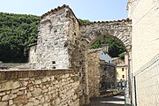 Defensive gate
 -
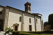 The church San Francesco
 -
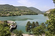 The Lake Lago di Caccamo
 -
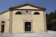 The church San Paolo in Borgiano


References
- v
- t
- e
- Apiro
- Appignano
- Belforte del Chienti
- Bolognola
- Caldarola
- Camerino
- Camporotondo di Fiastrone
- Castelraimondo
- Castelsantangelo sul Nera
- Cessapalombo
- Cingoli
- Civitanova Marche
- Colmurano
- Corridonia
- Esanatoglia
- Fiastra
- Fiuminata
- Gagliole
- Gualdo
- Loro Piceno
- Macerata
- Matelica
- Mogliano
- Monte Cavallo
- Monte San Giusto
- Monte San Martino
- Montecassiano
- Montecosaro
- Montefano
- Montelupone
- Morrovalle
- Muccia
- Penna San Giovanni
- Petriolo
- Pieve Torina
- Pioraco
- Poggio San Vicino
- Pollenza
- Porto Recanati
- Potenza Picena
- Recanati
- Ripe San Ginesio
- San Ginesio
- San Severino Marche
- Sant'Angelo in Pontano
- Sarnano
- Sefro
- Serrapetrona
- Serravalle di Chienti
- Tolentino
- Treia
- Urbisaglia
- Ussita
- Valfornace
- Visso
Authority control databases | |
|---|---|
| International |
|
| National |
|
 | This Marche location article is a stub. You can help Wikipedia by expanding it. |
- v
- t
- e


