Sainte-Rose, Quebec
You can help expand this article with text translated from the corresponding article in French. (February 2012) Click [show] for important translation instructions.
- View a machine-translated version of the French article.
- Machine translation, like DeepL or Google Translate, is a useful starting point for translations, but translators must revise errors as necessary and confirm that the translation is accurate, rather than simply copy-pasting machine-translated text into the English Wikipedia.
- Do not translate text that appears unreliable or low-quality. If possible, verify the text with references provided in the foreign-language article.
- You must provide copyright attribution in the edit summary accompanying your translation by providing an interlanguage link to the source of your translation. A model attribution edit summary is
Content in this edit is translated from the existing French Wikipedia article at [[:fr:Sainte-Rose (Laval)]]; see its history for attribution. - You may also add the template
{{Translated|fr|Sainte-Rose (Laval)}}to the talk page. - For more guidance, see Wikipedia:Translation.
Sainte-Rose is a district in Laval, Quebec. It was incorporated as a village in 1850, and was a separate town until the municipal mergers on August 6, 1965 which amalgamated all the municipalities on Île Jésus into a single City of Laval.
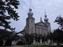
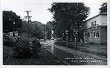
Ste-Rose is best known for the parish church, erected 1740, which contains a Casavant Frères organ and hosts numerous concerts every year, and for "Vieux Ste-Rose", an area known for its old houses and its restaurants. Other districts that are also part of Sainte-Rose are Champenois (located between Boulevard Curé-Labelle and Autoroute 15, to the west of "Vieux Ste-Rose") and Champfleury, also known as Des Oiseaux (after the name of the district's main thoroughfare), to the south, near the border with Chomedey.
Transportation
It is served by city bus lines operated by the Société de transport de Laval and by commuter trains of the Saint-Jerome line of the Réseau de transport métropolitain (RTM). The Sainte-Rose station on that line is located just east of "Vieux Ste-Rose", on the border with Auteuil.
Geography
Sainte-Rose is delimited on the north by the Rivière des Mille-Îles, on the west by Fabreville, on the north-east by Auteuil, on the south-east by Vimont and on the south by Chomedey.[1]
Education
Commission scolaire de Laval operates French-language public schools.
- Écoles secondaire Curé-Antoine-Labelle
- École primaire Demers[2]
- École primaire Des Cardinaux[3]
- École primaire Du Parc[4]
- École primaire L’Envolée[5]
- École primaire L’Aquarelle[6]
- École primaire Villemaire[7]
- École primaire Le Baluchon (alternative school)[8]
Sir Wilfrid Laurier School Board operates English-language public schools. All sections of Laval are zoned to Laval Junior Academy and Laval Senior Academy.
Trivia
- Antoine Labelle, priest and proponent of the settlement of the Laurentians, was born and lived there. His house is classified as an historic building.
- It is also the birthplace of painter Marc-Aurèle Fortin.
- Les Patriotes of the Lower Canada Rebellion gathered at a hotel on a road that is known today as the "rue des Patriotes" (street of the Patriots).
References
- ^ Interactive map of Laval from the official website Archived 2005-04-07 at the Wayback Machine Shows both the borders and names of the 14 former municipalities (purple) and the borders only of the current 6 sectors (maroon), tick off both boxes beside "Limite administrative".
- ^ "Demers." Commission scolaire de Laval. Retrieved on September 24, 2017.
- ^ "Des Cardinaux." Commission scolaire de Laval. Retrieved on September 24, 2017.
- ^ "Du Parc." Commission scolaire de Laval. Retrieved on September 24, 2017.
- ^ "L’Envolée." Commission scolaire de Laval. Retrieved on September 24, 2017.
- ^ "L’Aquarelle." Commission scolaire de Laval. Retrieved on September 24, 2017.
- ^ "Villemaire." Commission scolaire de Laval. Retrieved on September 24, 2017.
- ^ "Le Baluchon (école alternative)." Commission scolaire de Laval. Retrieved on September 24, 2017.
- Sainte-Rose at the Commission de toponymie du Québec
External links
Wikimedia Commons has media related to Sainte-Rose (Laval).
- City of Laval, official website
Authority control databases | |
|---|---|
| International |
|
| National |
|
| Geographic |
|
45°37′N 73°47′W / 45.617°N 73.783°W / 45.617; -73.783
| |||
|---|---|---|---|
| Neighbourhoods | |||
| Administration | |||
| Public services | |||
| Education |
| ||
| Other | |||
| |||


