Rushworth, Victoria
Town in Victoria, Australia
36°35′0″S 145°01′0″E / 36.58333°S 145.01667°E / -36.58333; 145.01667- 157 km (98 mi) N of Melbourne
- 47 km (29 mi) SW of Shepparton
Wikimedia Commons has media related to Rushworth, Victoria.
Rushworth is a township in Victoria, Australia. It is located 157 kilometres (98 mi) north of Melbourne and, at the 2016 Census, had a population of 1,335.[1]
History
Rushworth was established during the Victorian gold rush in 1853. It was named by poet and later local Goldfields Commissioner Richard Henry Horne in 1854. Its post office opened on 16 September 1857.[2]
The goldfields became no longer viable due to the underground water table and were closed during the gold rush.
The Rushworth Magistrates' Court closed on 1 January 1990.[3]
Athletics
The town has an Australian rules football team competing in the Kyabram & District Football League.[4]
Golfers play at the course of the Rushworth Golf Club on Tatura Road.[5]
Gallery
-
 Aerial Picture
 -
 Main Street
 -
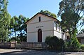
 Presbyterian Church
 -
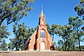 Anglican Church
 -
 Court House
 -
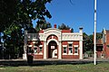 Mechanics Institute
 -
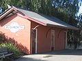
 Post Office
 -
 Public Toilet
 -
 War Memorial


See also
- Whroo, Victoria
- Balaclava Mine
References
- ^ a b Australian Bureau of Statistics (27 June 2017). "Rushworth (State Suburb)". 2016 Census QuickStats. Retrieved 4 December 2014.

- ^ Post Office List, Phoenix Auctions History, retrieved 12 April 2021
- ^ "Review of Legal Services in Rural and Regional Victoria" (PDF). Parliament of Victoria Law Reform Committee. May 2001. pp. 291–292. Retrieved 12 April 2020.
- ^ Full Points Footy, Rushworth, archived from the original on 5 June 2008, retrieved 25 July 2008
- ^ Golf Select, Rushworth, retrieved 11 May 2009
- v
- t
- e
Localities in the Shire of Campaspe

- Bamawm
- Bamawm Extension
- Ballendella
- Bonn
- Burnewang
- Burramboot
- Carag Carag
- Cornella
- Creek View
- Diggora
- Echuca Village
- Echuca West
- Fairy Dell
- Gobarup
- Kanyapella
- Kotta
- Koyuga
- Kyvalley
- Lancaster^
- Milloo^
- Moora
- Muskerry
- Myola
- Patho
- Pine Grove
- Redcastle^
- Roslynmead
- Runnymede
- Strathallan
- Tennyson
- Terrick Terrick East
- Timmering
- Wanalta
- Waranga Shores
- Whroo^
- Wharparilla
- Wyuna^
- Wyuna East
- Yambuna
^ - Territory divided with another LGA
Authority control databases | |
|---|---|
| International |
|
| National |
|
 | This article about a location in Victoria, Australia is a stub. You can help Wikipedia by expanding it. |
- v
- t
- e


