Pemzashen
40°35′36″N 43°56′24″E / 40.59333°N 43.94000°E / 40.59333; 43.94000
Place in Shirak, Armenia
Pemzashen Պեմզաշեն | |
|---|---|
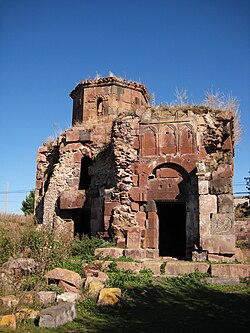 Pemzashen Church, 7th century | |
 Coat of arms | |
  Pemzashen 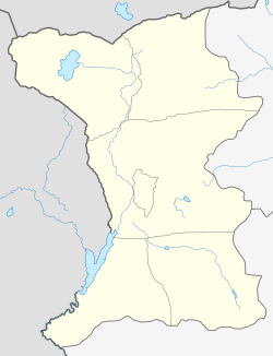 Pemzashen | |
| Coordinates: 40°35′36″N 43°56′24″E / 40.59333°N 43.94000°E / 40.59333; 43.94000 | |
| Country | Armenia |
| Province | Shirak |
| Municipality | Artik |
| Government | |
| • Mayor | Ananik Voskanyan |
| Population (2008) | |
| • Total | 2,646 |
Pemzashen (Armenian: Պեմզաշեն) is a village in the Artik Municipality of the Shirak Province of Armenia. During the Soviet era a sewing factory, construction materials plant, and a parts factory to supply hydro-electric stations were based out of Pemzashen. After the collapse of the USSR, most of the village's residents have found themselves out of work and many of the men have moved to Russia to find jobs. In the past 15 years, over 300 families have moved away from the village. There is also the problem of a lack of irrigation water for crops or household gardens, and the land around the village is not flat or fertile (due to no irrigation). Plans are currently underway to put in an irrigation system.
In the middle of village is a 7th-century church adjacent to the foundations of a 5th-century basilica. Just west of the village off of the main road leading from Pemzashen to Artik is Arakelots Vank of the 11th century. Along the road south to Lernakert, is also Makaravank built in the 10th to 13th centuries, with the church of Surb Sion of 1001. In the gorge below is a small church built on earlier foundations constructed in the 18th century with a hermit's cell cut into the cliff face behind.
Demographics
| Year | Pop. | ±% p.a. | |
|---|---|---|---|
| 1831 | 191 | — | |
| 1897 | 1,496 | +3.17% | |
| 1926 | 1,331 | −0.40% | |
| 1939 | 1,757 | +2.16% | |
| 1959 | 3,599 | +3.65% | |
| 1989 | 3,384 | −0.21% | |
| 2001 | 2,862 | −1.39% | |
| 2004 | 2,701 | −1.91% | |
| |||
| Source: [1] | |||
Gallery
-
 Arakelots Vank northwest corner, 11th century
 -
 Makaravank Church, 10th-13th century
 -
 18th-century chapel in gorge below Makaravank


References
- ^ Հայաստանի Հանրապետության բնակավայրերի բառարան [Republic of Armenia settlements dictionary] (PDF) (in Armenian). Yerevan: Cadastre Committee of the Republic of Armenia. 2008. Archived from the original (PDF) on 11 March 2018.
- Pemzashen at GEOnet Names Server
- World Gazeteer: Armenia[dead link] – World-Gazetteer.com
- Report of the results of the 2001 Armenian Census, Statistical Committee of Armenia
- Kiesling, Brady (2005), Rediscovering Armenia: Guide, Yerevan, Armenia: Matit Graphic Design Studio
- Kiesling, Brady (June 2000). Rediscovering Armenia: An Archaeological/Touristic Gazetteer and Map Set for the Historical Monuments of Armenia (PDF). Archived (PDF) from the original on 6 November 2021.
External links
- Article: Pemzashen
- v
- t
- e
 Shirak Province
Capital: Gyumri
- Artik
- Gyumri
- Maralik

 | This article about a location in Shirak Province, Armenia is a stub. You can help Wikipedia by expanding it. |
- v
- t
- e


