Panheel
Village in Limburg, Netherlands
Panheel Panhael | |
|---|---|
Village | |
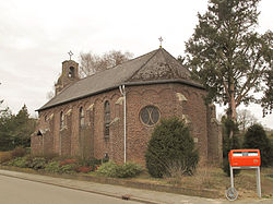 Onze Lieve Vrouwe van 't Hart Chapel | |
 Flag | |
51°11′N 5°52′E / 51.183°N 5.867°E / 51.183; 5.867 | |
| Country |  Netherlands Netherlands |
| Province |  Limburg Limburg |
| Municipality |  Maasgouw Maasgouw |
| Area | |
| • Total | 1.19 km2 (0.46 sq mi) |
| Elevation | 24 m (79 ft) |
| Population (2021)[1] | |
| • Total | 225 |
| • Density | 190/km2 (490/sq mi) |
| Time zone | UTC+1 (CET) |
| • Summer (DST) | UTC+2 (CEST) |
| Postal code | 6097[1] |
| Dialing code | 0475 |
Panheel is a village in the Dutch province of Limburg. It is a part of the municipality of Maasgouw, and lies about 9 km south-west of Roermond.
The village was first mentioned in 1417 or 1418 as Panhedel. The etymology is unclear.[3]
Panheel was home to 175 people in 1840. In 1875, a chapel was built. Panheel was never elevated to a parish,[4] however it is considered a village by the municipality.[5]
The Boschmolenplas is a lake which formed as a result of gravel excavation. It has a diameter of 1 kilometre (0.62 mi) and has clear water with a visibility of 12 metres. It is therefore, a popular diving spot.[4]
Gallery
-
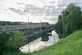 Lock near Panheel
 -
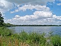 Boschmolenplas


References
- ^ a b c "Kerncijfers wijken en buurten 2021". Central Bureau of Statistics. Retrieved 25 April 2022.
- ^ "Postcodetool for 6097AA". Actueel Hoogtebestand Nederland (in Dutch). Het Waterschapshuis. Retrieved 25 April 2022.
- ^ "Panheel - (geografische naam)". Etymologiebank (in Dutch). Retrieved 25 April 2022.
- ^ a b "Panheel". Plaatsengids (in Dutch). Retrieved 25 April 2022.
- ^ "Heel en Panheel". Gemeente Maasgouw (in Dutch). Retrieved 25 April 2022.
- v
- t
- e
Populated places in the municipality of Maasgouw
- Maasbracht
- Wessem
- Beegden
- Brachterbeek [nl]
- Heel
- Linne
- Ohé en Laak
- Panheel
- Stevensweert
- Thorn
List of cities, towns and villages in Limburg (Netherlands)
 | This Dutch Limburg location article is a stub. You can help Wikipedia by expanding it. |
- v
- t
- e


