Paintsville Lake
Reservoir in Johnson and Morgan Counties, Kentucky
37°50′23.34″N 82°52′15.56″W / 37.8398167°N 82.8709889°W / 37.8398167; -82.8709889Paintsville Lake is a 1,139-acre (4.61 km2) reservoir in Johnson and Morgan counties in eastern Kentucky. It was impounded from Paint Creek in 1983 by the United States Army Corps of Engineers. It is the major attraction of Paintsville Lake State Park.[2]
History
Paintsville Lake officially opened to the public in 1983, three years before Paintsville Lake State Park was established.
On December 9, 1978, ten-thousand Johnson County residences had to be evacuated from the area below the construction site of the Paintsville Lake dam. This is because the area had recently received eight inches (200 mm) of rain, which had caused a leak in the coffer dam that was keeping the construction site of the actual dam dry. The dam did not break, and the residents were allowed to return to their homes the following day.[3]
Fish species
Paintsville Lake has a variety of game fishing species. Fish that can be caught in the lake include:[1]
|
|
Gallery
-
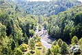 Paintsville Lake spillway
 -
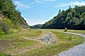
 Rocky Knob Recreational Area
 -
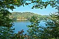 Paintsville Lake as viewed from the Kiwanis Trail
 -
 Paintsville Lake's emergency spillway


See also
References
- ^ a b lakelubbers.com-Paintsville Lake Retrieved on 2009-06-23
- ^ Kleber, John E., ed. (1992). "Lakes". The Kentucky Encyclopedia. Associate editors: Thomas D. Clark, Lowell H. Harrison, and James C. Klotter. Lexington, Kentucky: The University Press of Kentucky. ISBN 0-8131-1772-0.
- ^ Johnson County History Retrieved on 2009-06-23
External links
- Paintsville Lake facilities map
- Paintsville Lake area interactive GIS map
- v
- t
- e
- Lake Barkley
- Barren River Lake
- Beaver Lake
- Boltz Lake
- Buckhorn Lake
- Bullock Pen Lake
- Lake Beshear
- Cannon Creek Lake
- Lake Carnico
- Carr Creek Lake
- Cave Run Lake
- Cedar Creek Lake
- Cranks Creek Lake
- Lake Cumberland
- Dale Hollow Lake
- Dewey Lake
- Doe Run Lake
- Elk Lake
- Elmer Davis Lake
- Fishtrap Lake
- Grayson Lake
- Green River Lake
- Greenbo Lake
- Guist Creek Lake
- Herrington Lake
- Kentucky Lake
- Kincaid Lake
- Laurel River Lake
- Lake Linville
- Lake Malone
- Martins Fork Lake
- Nolin River Lake
- Paintsville Lake
- Pan Bowl Lake
- Rough River Lake
- Shanty Hollow Lake
- Shelby Lake
- Swan Lake
- Taylorsville Lake
- Wilgreen Lake
- Williamstown Lake
- Willisburg Lake
- Wood Creek Lake
- Yatesville Lake

 Kentucky portal •
  Lakes portal


Authority control databases | |
|---|---|
| International |
|
| National |
|
 | This Johnson County, Kentucky state location article is a stub. You can help Wikipedia by expanding it. |
- v
- t
- e
 | This Morgan County, Kentucky state location article is a stub. You can help Wikipedia by expanding it. |
- v
- t
- e


