Oud Ade
Village in South Holland, Netherlands
52°11′N 4°34′E / 52.183°N 4.567°E / 52.183; 4.567 (2021)[1]
2374[1]
Oud Ade (also: Oud-Ade[3]) is a village in the Dutch province of South Holland. It is a part of the municipality of Kaag en Braassem, and lies about 7 km east of Leiden.
The village was first mentioned in 1395 or 1396 "Ecclesia de A". The current name means "the old river".[4] Oud Ade developed as a peat excavation settlement, but remained a small linear settlement. It developed into the village in the 1960s by the addition of planned neighbourhoods. The Catholic St Bavo Church was built in 1868.[3]
Gallery
-
 Catholic church and presbytery
 -
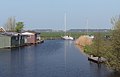 Panorama between Oud Ade and Warmond


References
- ^ a b c "Kerncijfers wijken en buurten 2021". Central Bureau of Statistics. Retrieved 4 May 2022.
combined with Zevenhuizen
- ^ "Postcodetool for 2374AA". Actueel Hoogtebestand Nederland (in Dutch). Het Waterschapshuis. 24 July 2019. Retrieved 4 May 2022.
- ^ a b "Oud-Ade". Plaatsengids (in Dutch). Retrieved 4 May 2022.
- ^ "Oud-Ade - (geografische naam)". Etymologiebank (in Dutch). Retrieved 4 May 2022.
Authority control databases | |
|---|---|
| International |
|
| National |
|
 | This South Holland location article is a stub. You can help Wikipedia by expanding it. |
- v
- t
- e


