Opal Cone
Mountain in British Columbia, Canada
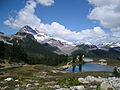
49°49′38.0″N 122°58′16.0″W / 49.827222°N 122.971111°W / 49.827222; -122.971111Opal Cone is a cinder cone located on the southeast flank of Mount Garibaldi in the Coast Mountains of British Columbia, Canada. It is the source of a 15 km (9 mi) long broad dacite lava flow with prominent wrinkled ridges. The lava flow is unusually long for a silicic lava flow.
Opal Cone is a member of the Cascade Volcanoes, but it is located in the Garibaldi Ranges in the Coast Mountains and not in the Cascade Range proper.
See also
- List of volcanoes in Canada
- Volcanism of Canada
- Volcanism of Western Canada
- Cascade Volcanoes
- Garibaldi Volcanic Belt
- Garibaldi Lake volcanic field
External links
- Opal Cone in the Canadian Mountain Encyclopedia
- Hiking Opal Cone - Online guide for hiking to the summit
References
- "Opal Cone". BC Geographical Names.
- Catalogue of Canadian volcanoes:Opal Cone
- v
- t
- e
- Bendor
- Britannia
- Bunster
- Cadwallader
- Calliope
- Camelsfoot
- Cantilever
- Caren
- Cayley
- Chilcotin
- Colville
- Conical
- Douglas
- Earle
- Edwards
- Fannin
- Fitzsimmons
- Franklyn
- Fraser
- Garibaldi
- Gastineau
- Georgina
- Koeye
- Lewis
- Lillooet
- Meager
- Namu
- Nicholl
- Niut
- North Shore
- Pantheon
- Pembroke
- Sir Harry
- Tantalus
- Tottenham
- Unwin
- Waddington
- Wharncliffe
- Whitemantle
- Akasik
- Alfred
- Alice
- Arthur
- Asperity
- Birkenhead
- Bishop
- The Black Tusk
- Blackcomb
- Blanshard
- Brandywine
- Breakenridge
- Brew
- Brew
- Burke
- Callaghan
- Capricorn
- Castle Towers
- Cauldron
- Cayley
- Cinder Cone
- Clarke
- Coquitlam
- Crevasse Crag
- Crickmer
- Crown
- Currie
- Cypress
- Devastator
- Dewdney
- Eagle
- Edge
- Elsay
- Fang
- Fee
- Fitzgerald
- Forefinger
- Frederick William
- Fromme
- Garibaldi
- Good Hope
- Grouse
- Helena
- Job
- Judge Howay
- ḵ’els
- Kinch
- Little Finger
- Little Ring
- Luna
- Mamquam
- Meager
- Merlon
- Middle Finger
- Monarch
- Monmouth
- Munday
- Nicomen
- One Eye
- Opal Cone
- Overill
- Pali
- Petlushkwohap
- Plinth
- Powder
- Price
- Pylon
- Pyroclastic
- Queen Bess
- Raleigh
- Red Tusk
- Ring
- Robie Reid
- Round
- Serratus
- Seymour
- Silverthrone
- Skihist
- Stein
- Somolenko
- Spearhead
- Table
- Tantalus
- Taseko
- Tatlow
- Tiedemann
- Tricouni
- Tuber
- Vic
- Vulcan's Thumb
- Waddington
- Wedge
- Wellington
- ʔEniyud (Niut)
- Clendinning
- Duffey Lake
- Garibaldi
- Mount Elphinstone
- Stein Valley Nlaka'pamux Heritage
- Spruce Lake (South Chilcotin)
- Upper Lillooet
- Golden Ears
- Tantalus
- Mehatl Creek
- Birkenhead Lake
- Joffre Lakes
- Ts'il?os
- Bishop River
- Princess Louisa Marine
- Callaghan
- Nairn Falls
- Brandywine Falls
- Alice Lake
- Blackcomb Glacier
- Tetrahedron
- Stawamus Chief
- Murrin
- Mount Seymour
- Cypress
- Say Nuth Khaw Yum (Indian Arm)
- Pinecone-Burke
- Shannon Falls
- Rolley Lake
- Sasquatch
- Big Creek
- Homathko Estuary
- Davis Lake
 | This article about a location on the Coast of British Columbia, Canada is a stub. You can help Wikipedia by expanding it. |
- v
- t
- e


