National Register of Historic Places listings in Washington County, Idaho

This is a list of the National Register of Historic Places listings in Washington County, Idaho.
This is intended to be a complete list of the properties and districts on the National Register of Historic Places in Washington County, Idaho, United States. Latitude and longitude coordinates are provided for many National Register properties and districts; these locations may be seen together in a map.[1]
There are 30 properties and districts listed on the National Register in the county. More may be added; properties and districts nationwide are added to the Register weekly.[2]
This National Park Service list is complete through NPS recent listings posted June 7, 2024.[3]
Map all coordinates using OpenStreetMap
Download coordinates as:
- KML
- GPX (all coordinates)
- GPX (primary coordinates)
- GPX (secondary coordinates)
Current listings
| [4] | Name on the Register[5] | Image | Date listed[6] | Location | City or town | Description |
|---|---|---|---|---|---|---|
| 1 | Anderson–Elwell House |  | November 17, 1982 (#82000373) | 547 W. 1st St. 44°14′51″N 116°58′16″W / 44.247463°N 116.971040°W / 44.247463; -116.971040 (Anderson–Elwell House) | Weiser | |
| 2 | Baptist Church |  | October 7, 1977 (#77000470) | E. Main and 8th Sts. 44°14′45″N 116°57′22″W / 44.245902°N 116.956160°W / 44.245902; -116.956160 (Baptist Church) | Weiser | |
| 3 | Butterfield Livestock Company House |  | November 17, 1982 (#82000374) | North of Weiser on Jenkins Creek Rd. 44°15′29″N 116°59′38″W / 44.258068°N 116.993986°W / 44.258068; -116.993986 (Butterfield Livestock Company House) | Weiser | |
| 4 | Cambridge News Office |  | December 28, 1989 (#89002128) | 155 N. Superior St. 44°34′24″N 116°40′30″W / 44.573212°N 116.675130°W / 44.573212; -116.675130 (Cambridge News Office) | Cambridge | |
| 5 | Col. C. F. Drake House |  | January 20, 1978 (#78001104) | 516 E. Main St. 44°14′45″N 116°57′39″W / 44.245924°N 116.960795°W / 44.245924; -116.960795 (Col. C. F. Drake House) | Weiser | |
| 6 | Edwards–Gillette Barn |  | February 19, 2002 (#02000013) | 3059 Rush Creek Rd. 44°35′43″N 116°42′06″W / 44.595225°N 116.701729°W / 44.595225; -116.701729 (Edwards–Gillette Barn) | Cambridge | |
| 7 | James M. Fisher House |  | September 4, 1986 (#86002146) | 598 Pioneer Rd. 44°15′12″N 116°58′37″W / 44.253261°N 116.976894°W / 44.253261; -116.976894 (James M. Fisher House) | Weiser | |
| 8 | Thomas C. Galloway House |  | January 26, 1978 (#78001105) | 1120 E. 2nd St. 44°15′10″N 116°58′00″W / 44.252661°N 116.966589°W / 44.252661; -116.966589 (Thomas C. Galloway House) | Weiser | |
| 9 | Bernard Haas House |  | May 22, 1978 (#78001106) | 377 E. Main St. 44°14′43″N 116°57′50″W / 44.245405°N 116.964013°W / 44.245405; -116.964013 (Bernard Haas House) | Weiser | |
| 10 | Herman Haas House |  | November 17, 1982 (#82000375) | 253 W. Idaho St. 44°14′47″N 116°58′27″W / 44.246340°N 116.974064°W / 44.246340; -116.974064 (Herman Haas House) | Weiser | |
| 10 | Institute Canal Company Pump House |  | May 8, 2017 (#100000958) | South end of Fairview St. at the Galloway Canal 44°15′24″N 116°58′12″W / 44.256628°N 116.969978°W / 44.256628; -116.969978 (Institute Canal Company Pump House) | Weiser | |
| 11 | Intermountain Institute |  | November 1, 1979 (#79000811) | Paddock Ave. 44°15′53″N 116°58′51″W / 44.264804°N 116.980731°W / 44.264804; -116.980731 (Intermountain Institute) | Weiser | |
| 12 | Jewell Building |  | January 18, 1990 (#89002263) | 15 N. Superior St. 44°34′19″N 116°40′36″W / 44.571982°N 116.676757°W / 44.571982; -116.676757 (Jewell Building) | Cambridge | |
| 13 | Knights of Pythias Lodge Hall | 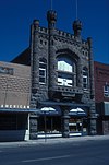 | May 13, 1976 (#76000683) | 30 E. Idaho St. 44°14′44″N 116°58′11″W / 44.245497°N 116.969747°W / 44.245497; -116.969747 (Knights of Pythias Lodge Hall) | Weiser | |
| 14 | Kurtz-Van Sicklin House |  | November 17, 1982 (#82000376) | 253 W. Main St. 44°14′50″N 116°58′25″W / 44.247165°N 116.973637°W / 44.247165; -116.973637 (Kurtz-Van Sicklin House) | Weiser | |
| 15 | Archie Larsen House |  | November 17, 1982 (#82000377) | South of Weiser on Larsen Rd. 44°11′43″N 116°56′11″W / 44.195270°N 116.936395°W / 44.195270; -116.936395 (Archie Larsen House) | Weiser | Building no longer exists. |
| 16 | G. V. Nesbit House |  | November 17, 1982 (#82000378) | 308 W. Liberty St. 44°14′58″N 116°58′23″W / 44.249344°N 116.972975°W / 44.249344; -116.972975 (G. V. Nesbit House) | Weiser | |
| 17 | Dr. J. R. Numbers House | 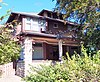 | November 17, 1982 (#82000379) | 240 W. Main St. 44°14′51″N 116°58′23″W / 44.247513°N 116.973161°W / 44.247513; -116.973161 (Dr. J. R. Numbers House) | Weiser | |
| 18 | St. Agnes Catholic Church |  | July 24, 1978 (#78001107) | 204 E. Liberty St. 44°14′53″N 116°58′00″W / 44.248187°N 116.966631°W / 44.248187; -116.966631 (St. Agnes Catholic Church) | Weiser | |
| 19 | St. Luke's Episcopal Church |  | July 24, 1978 (#78001108) | E. 1st and Liberty Sts. 44°14′53″N 116°58′04″W / 44.248139°N 116.967821°W / 44.248139; -116.967821 (St. Luke's Episcopal Church) | Weiser | |
| 20 | Salubria Lodge No. 31 | 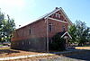 | March 9, 1990 (#90000368) | 85 W. Central Blvd. 44°34′23″N 116°40′36″W / 44.573110°N 116.676548°W / 44.573110; -116.676548 (Salubria Lodge No. 31) | Cambridge | |
| 21 | Morris Sommer House |  | November 17, 1982 (#82000380) | 548 W. 2nd St. 44°14′52″N 116°58′21″W / 44.247784°N 116.972362°W / 44.247784; -116.972362 (Morris Sommer House) | Weiser | |
| 22 | Mary Elizabeth Sommercamp House |  | November 17, 1982 (#82000381) | 411 W. 3rd St. 44°14′49″N 116°58′28″W / 44.246950°N 116.974382°W / 44.246950; -116.974382 (Mary Elizabeth Sommercamp House) | Weiser | |
| 23 | Star Theater |  | November 30, 1999 (#99001413) | 342 State St. 44°14′43″N 116°58′13″W / 44.245271°N 116.970308°W / 44.245271; -116.970308 (Star Theater) | Weiser | |
| 24 | B. S. Varian House |  | November 17, 1982 (#82000382) | 241 W. Main St. 44°14′49″N 116°58′24″W / 44.247070°N 116.973395°W / 44.247070; -116.973395 (B. S. Varian House) | Weiser | |
| 25 | Washington County Courthouse |  | September 28, 1987 (#87001602) | E. Court St. 44°14′51″N 116°57′59″W / 44.247458°N 116.966280°W / 44.247458; -116.966280 (Washington County Courthouse) | Weiser | |
| 26 | Benjamin Watlington House | 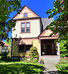 | April 26, 1991 (#91000458) | 206 W. Court St. 44°14′53″N 116°58′20″W / 44.248179°N 116.972159°W / 44.248179; -116.972159 (Benjamin Watlington House) | Weiser | |
| 27 | Weiser Oregon Short Line Railroad Depot |  | February 7, 2007 (#07000006) | 1 State St. 44°14′38″N 116°58′17″W / 44.243920°N 116.971290°W / 44.243920; -116.971290 (Weiser Oregon Short Line Railroad Depot) | Weiser | |
| 28 | Weiser Post Office |  | November 17, 1982 (#82000383) | Main and W. 1st Sts. 44°14′49″N 116°58′17″W / 44.246936°N 116.971460°W / 44.246936; -116.971460 (Weiser Post Office) | Weiser | |
| 29 | Wilson House |  | January 6, 2004 (#03001369) | 75 N. 5th St. 44°34′35″N 116°40′55″W / 44.576303°N 116.681826°W / 44.576303; -116.681826 (Wilson House) | Cambridge |
See also
Wikimedia Commons has media related to National Register of Historic Places in Washington County, Idaho.
References
- ^ The latitude and longitude information provided in this table was derived originally from the National Register Information System, which has been found to be fairly accurate for about 99% of listings. Some locations in this table may have been corrected to current GPS standards.
- ^ "National Register of Historic Places: Weekly List Actions". National Park Service. Retrieved March 29, 2009.
- ^ National Park Service, United States Department of the Interior, "National Register of Historic Places: Weekly List Actions", retrieved June 7, 2024.
- ^ Numbers represent an alphabetical ordering by significant words. Various colorings, defined here, differentiate National Historic Landmarks and historic districts from other NRHP buildings, structures, sites or objects.
- ^ "National Register Information System". National Register of Historic Places. National Park Service. April 24, 2008.
- ^ The eight-digit number below each date is the number assigned to each location in the National Register Information System database, which can be viewed by clicking the number.
- v
- t
- e
- Ada
- Adams
- Bannock
- Bear Lake
- Benewah
- Bingham
- Blaine
- Boise
- Bonner
- Bonneville
- Boundary
- Butte
- Camas
- Canyon
- Caribou
- Cassia
- Clark
- Clearwater
- Custer
- Elmore
- Franklin
- Fremont
- Gem
- Gooding
- Idaho
- Jefferson
- Jerome
- Kootenai
- Latah
- Lemhi
- Lewis
- Lincoln
- Madison
- Minidoka
- Nez Perce
- Oneida
- Owyhee
- Payette
- Power
- Shoshone
- Teton
- Twin Falls
- Valley
- Washington

| |
|---|---|
| Topics | |
| Lists by state |
|
| Lists by insular areas | |
| Lists by associated state | |
| Other areas | |
| Related | |
| |


