National Register of Historic Places listings in Virginia Beach, Virginia

This is a list of the National Register of Historic Places listings in Virginia Beach, Virginia.
This is intended to be a complete list of the properties and districts on the National Register of Historic Places in the independent city of Virginia Beach, Virginia, United States. The locations of National Register properties and districts for which the latitude and longitude coordinates are included below, may be seen in an online map.[1]
There are 32 properties and districts listed on the National Register in the city, including 2 National Historic Landmarks. Another property was once listed but has been removed.
This National Park Service list is complete through NPS recent listings posted May 3, 2024.[2]
Map all coordinates using OpenStreetMap
Download coordinates as:
- KML
- GPX (all coordinates)
- GPX (primary coordinates)
- GPX (secondary coordinates)
Current listings
| [3] | Name on the Register[4] | Image | Date listed[5] | Location | Description |
|---|---|---|---|---|---|
| 1 | Blue Marlin Lodge |  | October 25, 2022 (#100008322) | 2411 Pacific Ave. 36°51′10″N 75°58′39″W / 36.8529°N 75.9774°W / 36.8529; -75.9774 (Blue Marlin Lodge) | |
| 2 | Briarwood |  | August 22, 2012 (#12000547) | 1500 Southwick Rd. 36°51′39″N 76°00′50″W / 36.860833°N 76.013889°W / 36.860833; -76.013889 (Briarwood) | |
| 3 | Camp Pendleton-State Military Reservation Historic District |  | September 26, 2005 (#04000852) | Roughly bounded by General Booth Boulevard, S. Birdneck Rd., and the Atlantic Ocean 36°48′44″N 75°59′06″W / 36.812222°N 75.985000°W / 36.812222; -75.985000 (Camp Pendleton-State Military Reservation Historic District) | |
| 4 | Cape Henry (Second Tower) Light Station | 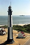 | December 2, 2002 (#02001439) | Atlantic Ave. 36°55′35″N 76°00′26″W / 36.926389°N 76.007222°W / 36.926389; -76.007222 (Cape Henry (Second Tower) Light Station) | |
| 5 | Cape Henry Lighthouse |  | October 15, 1966 (#66000910) | Atlantic Ave. at U.S. Route 60 36°55′33″N 76°00′29″W / 36.925833°N 76.008056°W / 36.925833; -76.008056 (Cape Henry Lighthouse) | |
| 6 | Cavalier Hotel |  | May 19, 2014 (#14000239) | 4200 Pacific Ave. 36°52′09″N 75°59′01″W / 36.869167°N 75.983611°W / 36.869167; -75.983611 (Cavalier Hotel) | |
| 7 | Cavalier Shores Historic District |  | April 2, 2019 (#100003606) | Generally bounded by 42nd St./Cavalier Dr., Hollies Rd., 45th St., and the Atlantic Ocean 36°52′20″N 75°59′02″W / 36.872222°N 75.983889°W / 36.872222; -75.983889 (Cavalier Shores Historic District) | |
| 8 | Crest Kitchenette Motel |  | October 25, 2022 (#100008323) | 3614 Atlantic Ave. 36°51′54″N 75°58′47″W / 36.8650°N 75.9798°W / 36.8650; -75.9798 (Crest Kitchenette Motel) | |
| 9 | de Witt Cottage |  | June 16, 1988 (#88000748) | 1106 Atlantic Ave. 36°50′26″N 75°58′21″W / 36.840556°N 75.972500°W / 36.840556; -75.972500 (de Witt Cottage) | |
| 10 | Ferry Plantation House |  | January 20, 2005 (#04001545) | 4136 Cheswick Ln. 36°51′43″N 76°07′05″W / 36.861944°N 76.118056°W / 36.861944; -76.118056 (Ferry Plantation House) | |
| 11 | Green Hill |  | February 5, 2013 (#12001273) | 1721 Lovetts Pond Lane 36°53′58″N 76°03′17″W / 36.899306°N 76.054722°W / 36.899306; -76.054722 (Green Hill) | |
| 12 | The Hermitage |  | February 14, 2008 (#08000079) | 4200 Hermitage 36°53′20″N 76°07′13″W / 36.888889°N 76.120278°W / 36.888889; -76.120278 (The Hermitage) | |
| 13 | Jefferson Manor Motel Apartments | Upload image | May 12, 2021 (#100006519) | 3300 Pacific Ave. 36°51′41″N 75°58′48″W / 36.8613°N 75.9801°W / 36.8613; -75.9801 (Jefferson Manor Motel Apartments) | |
| 14 | Keeling House |  | June 19, 1973 (#73002297) | 3157 Adam Keeling Rd. 36°54′02″N 76°04′45″W / 36.900556°N 76.079167°W / 36.900556; -76.079167 (Keeling House) | |
| 15 | L & J Gardens Neighborhood Historic District | Upload image | August 30, 2022 (#100008084) | Northampton Blvd., Norwich Ave., Maywood Blvd., and Wesleyan Dr. 36°52′30″N 76°11′13″W / 36.8750°N 76.1869°W / 36.8750; -76.1869 (L & J Gardens Neighborhood Historic District) | |
| 16 | Francis Land House |  | May 12, 1975 (#75002118) | 3133 Virginia Beach Boulevard 36°50′32″N 76°04′46″W / 36.842222°N 76.079444°W / 36.842222; -76.079444 (Francis Land House) | |
| 17 | Dr. John Miller-Masury House |  | May 23, 1997 (#97000488) | 515 Wilder Point 36°52′42″N 75°59′31″W / 36.878333°N 75.991944°W / 36.878333; -75.991944 (Dr. John Miller-Masury House) | |
| 18 | Thomas Murray House |  | May 19, 2004 (#04000482) | 3425 S. Crestline Dr. 36°49′33″N 76°12′49″W / 36.825972°N 76.213611°W / 36.825972; -76.213611 (Thomas Murray House) | |
| 19 | Oceana Neighborhood Historic District | 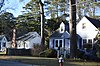 | September 18, 2017 (#100001645) | Indiana, Louisa, Michigan, New York, and Ohio Aves., Middle, Roselynn, and West Lns., Oceana, Southern, and Virginia Beach Boulevards 36°50′28″N 76°00′54″W / 36.841111°N 76.015000°W / 36.841111; -76.015000 (Oceana Neighborhood Historic District) | |
| 20 | Old Donation Church |  | April 13, 1972 (#72001534) | 4449 N. Witch Duck Rd. 36°52′01″N 76°07′44″W / 36.866944°N 76.128889°W / 36.866944; -76.128889 (Old Donation Church) | |
| 21 | Pembroke Manor | 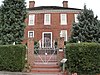 | February 26, 1970 (#70000887) | North of the junction of U.S. Route 58 and Constitution Dr. 36°51′08″N 76°08′02″W / 36.852222°N 76.133889°W / 36.852222; -76.133889 (Pembroke Manor) | |
| 22 | Pleasant Hall |  | January 25, 1973 (#73002229) | 5184 Princess Anne Rd. 36°49′40″N 76°09′44″W / 36.827778°N 76.162222°W / 36.827778; -76.162222 (Pleasant Hall) | |
| 23 | Seashore State Park Historic District | 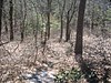 | November 16, 2005 (#05001267) | 2500 Shore Dr. 36°54′58″N 76°02′26″W / 36.916111°N 76.040556°W / 36.916111; -76.040556 (Seashore State Park Historic District) | Now known as First Landing State Park |
| 24 | Shirley Hall | 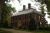 | February 5, 1999 (#99000144) | 1109 S. Bay Shore Dr. 36°52′25″N 76°00′27″W / 36.873611°N 76.007500°W / 36.873611; -76.007500 (Shirley Hall) | |
| 25 | Thoroughgood House | 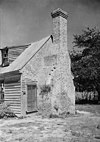 | October 15, 1966 (#66000921) | 1636 Parish Rd. 36°53′37″N 76°06′48″W / 36.893611°N 76.113333°W / 36.893611; -76.113333 (Thoroughgood House) | |
| 26 | Virginia Beach Surf & Rescue Museum |  | July 11, 1979 (#79003304) | Atlantic Ave. and 24th St. 36°51′08″N 75°58′32″W / 36.852222°N 75.975556°W / 36.852222; -75.975556 (Virginia Beach Surf & Rescue Museum) | |
| 27 | Upper Wolfsnare |  | March 26, 1975 (#75002119) | East of the junction of Potters and London Bridge Rds. 36°50′27″N 76°02′20″W / 36.840833°N 76.038889°W / 36.840833; -76.038889 (Upper Wolfsnare) | |
| 28 | Virginia Beach Courthouse Village and Municipal Center Historic District |  | June 4, 2018 (#100002196) | Courthouse Dr. and Mattaponi, N. Landing, and Princess Anne Rds. 36°45′04″N 76°03′24″W / 36.751111°N 76.056667°W / 36.751111; -76.056667 (Virginia Beach Courthouse Village and Municipal Center Historic District) | |
| 29 | Weblin House |  | November 8, 1974 (#74002248) | 5588 Moore's Pond Rd. 36°52′31″N 76°09′59″W / 36.875278°N 76.166250°W / 36.875278; -76.166250 (Weblin House) | |
| 30 | Wishart-Boush House (aka Lynnhaven House) |  (aka Lynnhaven House) | November 12, 1969 (#69000363) | East of the junction of Wishart Rd. and Independence Boulevard 36°52′24″N 76°07′37″W / 36.873333°N 76.126944°W / 36.873333; -76.126944 (Wishart-Boush House (aka Lynnhaven House)) | |
| 31 | Woodhouse House | 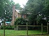 | April 24, 2007 (#07000372) | 3067 W. Neck Rd. 36°43′41″N 76°03′11″W / 36.728056°N 76.053056°W / 36.728056; -76.053056 (Woodhouse House) | |
| 32 | Woodhurst Neighborhood Historic District | Upload image | March 7, 2023 (#100008701) | Graham, Indian Run, and Mill Dam Rds., Strawberry Ln. and, Woodhurst Dr. 36°52′36″N 76°01′57″W / 36.8766°N 76.0326°W / 36.8766; -76.0326 (Woodhurst Neighborhood Historic District) |
Former listing
| [3] | Name on the Register | Image | Date listed | Date removed | Location | City or town | Description |
|---|---|---|---|---|---|---|---|
| 1 | Bayville Farm | Upload image | May 19, 1980 (#80004317) | June 4, 2008 | Off VA 650 36°53′59″N 76°06′39″W / 36.899722°N 76.110833°W / 36.899722; -76.110833 (Bayville Farm) | Virginia Beach | Destroyed by fire 2007 |
See also
Wikimedia Commons has media related to National Register of Historic Places in Virginia Beach, Virginia.
- List of National Historic Landmarks in Virginia
- National Register of Historic Places listings in Virginia
References
- ^ The latitude and longitude information provided in this table was derived originally from the National Register Information System, which has been found to be fairly accurate for about 99% of listings. Some locations in this table may have been corrected to current GPS standards.
- ^ National Park Service, United States Department of the Interior, "National Register of Historic Places: Weekly List Actions", retrieved May 3, 2024.
- ^ a b Numbers represent an alphabetical ordering by significant words. Various colorings, defined here, differentiate National Historic Landmarks and historic districts from other NRHP buildings, structures, sites or objects.
- ^ "National Register Information System". National Register of Historic Places. National Park Service. April 24, 2008.
- ^ The eight-digit number below each date is the number assigned to each location in the National Register Information System database, which can be viewed by clicking the number.
- v
- t
- e
by county
- Accomack
- Albemarle
- Alleghany
- Amelia
- Amherst
- Appomattox
- Arlington
- Augusta
- Bath
- Bedford
- Bland
- Botetourt
- Brunswick
- Buchanan
- Buckingham
- Campbell
- Caroline
- Carroll
- Charles City
- Charlotte
- Chesterfield
- Clarke
- Craig
- Culpeper
- Cumberland
- Dickenson
- Dinwiddie
- Essex
- Fairfax
- Fauquier
- Floyd
- Fluvanna
- Franklin
- Frederick
- Giles
- Gloucester
- Goochland
- Grayson
- Greene
- Greensville
- Halifax
- Hanover
- Henrico
- Henry
- Highland
- Isle Of Wight
- James City
- King and Queen
- King George
- King William
- Lancaster
- Lee
- Loudoun
- Louisa
- Lunenburg
- Madison
- Mathews
- Mecklenburg
- Middlesex
- Montgomery
- Nelson
- New Kent
- Northampton
- Northumberland
- Nottoway
- Orange
- Page
- Patrick
- Pittsylvania
- Powhatan
- Prince Edward
- Prince George
- Prince William
- Pulaski
- Rappahannock
- Richmond
- Roanoke
- Rockbridge
- Rockingham
- Russell
- Scott
- Shenandoah
- Smyth
- Southampton
- Spotsylvania
- Stafford
- Surry
- Sussex
- Tazewell
- Warren
- Washington
- Westmoreland
- Wise
- Wythe
- York

by city
- Alexandria
- Bristol
- Buena Vista
- Charlottesville
- Chesapeake
- Colonial Heights
- Covington
- Danville
- Emporia
- Fairfax
- Falls Church
- Franklin
- Fredericksburg
- Galax
- Hampton
- Harrisonburg
- Hopewell
- Lexington
- Lynchburg
- Manassas
- Manassas Park
- Martinsville
- Newport News
- Norfolk
- Norton
- Petersburg
- Poquoson (no listings)
- Portsmouth
- Radford
- Richmond
- Roanoke
- Salem
- Staunton
- Suffolk
- Virginia Beach
- Waynesboro
- Williamsburg
- Winchester


