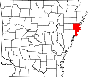
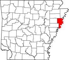
National Register of Historic Places listings in Crittenden County, Arkansas
This is a list of the National Register of Historic Places listings in Crittenden County, Arkansas.
This is intended to be a complete list of the properties and districts on the National Register of Historic Places in Crittenden County, Arkansas, United States. The locations of National Register properties and districts for which the latitude and longitude coordinates are included below, may be seen in a map.[1]
There are 17 properties and districts listed on the National Register in the county.
This National Park Service list is complete through NPS recent listings posted June 7, 2024.[2]
Map all coordinates using OpenStreetMap
Download coordinates as:
- KML
- GPX (all coordinates)
- GPX (primary coordinates)
- GPX (secondary coordinates)
Current listings
| [3] | Name on the Register[4] | Image | Date listed[5] | Location | City or town | Description |
|---|---|---|---|---|---|---|
| 1 | Crittenden County Bank and Trust Company |  | April 19, 1984 (#84000662) | Military Road 35°12′51″N 90°11′44″W / 35.214167°N 90.195556°W / 35.214167; -90.195556 (Crittenden County Bank and Trust Company) | Marion | |
| 2 | Crittenden County Courthouse |  | August 3, 1977 (#77000251) | 85 Jackson Street 35°12′57″N 90°11′45″W / 35.215833°N 90.195833°W / 35.215833; -90.195833 (Crittenden County Courthouse) | Marion | |
| 3 | Dabbs Store | 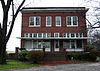 | May 17, 1982 (#82002112) | 1320 South Avalon 35°07′47″N 90°11′36″W / 35.129722°N 90.193333°W / 35.129722; -90.193333 (Dabbs Store) | West Memphis | |
| 4 | Hamilton Apartments |  | June 3, 1998 (#98000618) | 113 West Danner Street 35°09′00″N 90°11′08″W / 35.15°N 90.185556°W / 35.15; -90.185556 (Hamilton Apartments) | West Memphis | |
| 5 | Highway A-7, Gilmore to Turrell |  | May 12, 2009 (#09000313) | Old U.S. Highway 63 between Acwin Street in Gilmore and ditch No. 2 in Turrell 35°24′35″N 90°16′43″W / 35.409747°N 90.278536°W / 35.409747; -90.278536 (Highway A-7, Gilmore to Turrell) | Gilmore | |
| 6 | Johnson-Portis House |  | September 21, 2017 (#100001648) | 400 N. Avalon St. 35°09′02″N 90°11′37″W / 35.150533°N 90.193586°W / 35.150533; -90.193586 (Johnson-Portis House) | West Memphis | |
| 7 | Lawrie House |  | March 28, 1996 (#96000330) | 600 North 7th Street 35°09′11″N 90°10′36″W / 35.153056°N 90.176667°W / 35.153056; -90.176667 (Lawrie House) | West Memphis | |
| 8 | Marion Colored High School | 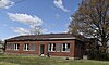 | March 23, 1995 (#95000349) | West of Highway 77 35°13′17″N 90°12′05″W / 35.221389°N 90.201389°W / 35.221389; -90.201389 (Marion Colored High School) | Sunset | |
| 9 | Memphis and Arkansas Bridge |  | February 16, 2001 (#01000139) | Interstate 55 35°07′47″N 90°04′45″W / 35.129722°N 90.079167°W / 35.129722; -90.079167 (Memphis and Arkansas Bridge) | West Memphis | Extends into Shelby County, Tennessee |
| 10 | Missouri Pacific Depot |  | March 6, 1986 (#86000383) | Main and Commerce Streets 35°16′10″N 90°27′59″W / 35.269444°N 90.466389°W / 35.269444; -90.466389 (Missouri Pacific Depot) | Earle | Currently the Crittenden County Museum |
| 11 | Old Earle High School |  | September 27, 2003 (#03000956) | Junction of Ruth Street and High Second Street (U.S. Highway 64B) 35°16′15″N 90°28′17″W / 35.270833°N 90.471389°W / 35.270833; -90.471389 (Old Earle High School) | Earle | |
| 12 | Old Turrell City Hall |  | September 19, 2007 (#07000962) | 160 Eureka Street 35°22′42″N 90°15′21″W / 35.378333°N 90.255833°W / 35.378333; -90.255833 (Old Turrell City Hall) | Turrell | |
| 13 | Riverside Speedway |  | January 21, 2010 (#09001243) | 151 Legion Road 35°08′44″N 90°08′02″W / 35.145511°N 90.133858°W / 35.145511; -90.133858 (Riverside Speedway) | West Memphis | |
| 14 | George Berry Washington Memorial |  | August 11, 1994 (#94000824) | Highway 149, north of Earle 35°17′50″N 90°28′01″W / 35.297222°N 90.466944°W / 35.297222; -90.466944 (George Berry Washington Memorial) | Earle | |
| 15 | West Memphis City Hall |  | July 8, 2010 (#10000444) | 100 Court Street 35°08′43″N 90°11′09″W / 35.145278°N 90.185833°W / 35.145278; -90.185833 (West Memphis City Hall) | West Memphis | |
| 16 | West Memphis Commercial Historic District | 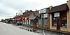 | July 24, 2008 (#08000704) | 700, 800, and 900 blocks of East Broadway 35°08′48″N 90°10′26″W / 35.146539°N 90.173967°W / 35.146539; -90.173967 (West Memphis Commercial Historic District) | West Memphis | |
| 17 | Wilson Power and Light Company Ice Plant |  | January 21, 2010 (#09001244) | 120 East Broadway 35°08′48″N 90°11′05″W / 35.146536°N 90.184631°W / 35.146536; -90.184631 (Wilson Power and Light Company Ice Plant) | West Memphis |
See also
Wikimedia Commons has media related to National Register of Historic Places in Crittenden County, Arkansas.
- List of National Historic Landmarks in Arkansas
- National Register of Historic Places listings in Arkansas
References
- ^ The latitude and longitude information provided in this table was derived originally from the National Register Information System, which has been found to be fairly accurate for about 99% of listings. Some locations in this table may have been corrected to current GPS standards.
- ^ National Park Service, United States Department of the Interior, "National Register of Historic Places: Weekly List Actions", retrieved June 7, 2024.
- ^ Numbers represent an alphabetical ordering by significant words. Various colorings, defined here, differentiate National Historic Landmarks and historic districts from other NRHP buildings, structures, sites or objects.
- ^ "National Register Information System". National Register of Historic Places. National Park Service. March 13, 2009.
- ^ The eight-digit number below each date is the number assigned to each location in the National Register Information System database, which can be viewed by clicking the number.
- v
- t
- e
- List of U.S. National Historic Landmarks by state:
- Alabama
- Alaska
- Arizona
- Arkansas
- California
- Colorado
- Connecticut
- Delaware
- Florida
- Georgia
- Hawaii
- Idaho
- Illinois
- Indiana
- Iowa
- Kansas
- Kentucky
- Louisiana
- Maine
- Maryland
- Massachusetts
- Michigan
- Minnesota
- Mississippi
- Missouri
- Montana
- Nebraska
- Nevada
- New Hampshire
- New Jersey
- New Mexico
- New York
- North Carolina
- North Dakota
- Ohio
- Oklahoma
- Oregon
- Pennsylvania
- Rhode Island
- South Carolina
- South Dakota
- Tennessee
- Texas
- Utah
- Vermont
- Virginia
- Washington
- West Virginia
- Wisconsin
- Wyoming
 National Register of Historic Places portal
 Category