Mount Boyce

Mount Boyce is located in New South Wales
Mount Boyce
Mount Boyce
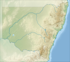
The location of Mount Boyce
in New South Wales
Highest pointElevation1,093 m (3,586 ft)[1]Coordinates33°37′10″S 150°16′28″E / 33.61948°S 150.274429°E / -33.61948; 150.274429GeographyLocationBlue Mountains region in New South Wales, AustraliaParent rangeBlue MountainsClimbingEasiest routeGreat Western Highway

Mount Boyce is a hill standing approximately 1,093 metres (3,586 ft) AMSL, situated as one of the highest points on a plateau within the Explorer Range, part of the Blue Mountains Range which is a spur off the Great Dividing Range. Mount Boyce is located 2 kilometres (1.2 mi) north of Blackheath, in New South Wales, Australia.[1]

Location and features

Mount Boyce is situated close to the point where the Great Western Highway passes by the location of a heavy vehicle checking station.[1] Approximately 300 metres (980 ft) west of Mount Boyce, the land drops sharply in cliffs and steep slopes to the Kanimbla Valley.

Mount Boyce was named on 26 April 1923 in honour of Venerable Archdeacon Francis Bertie Boyce FRGS, FRHS, an Australian clergyman and social reformer, who was born in England in 1844 and died in Blackheath in 1931.[1]

Climate

Mount Boyce has an oceanic climate with mild summers and cool winters. Due to its elevation, it has a highland influence.

Climate data for Mount Boyce AWS (1990–2020); 1,080 m AMSL; 33.62° S, 150.27° E
Month Jan Feb Mar Apr May Jun Jul Aug Sep Oct Nov Dec Year
Record high °C (°F) 38.0
(100.4)
38.0
(100.4)
32.5
(90.5)
27.9
(82.2)
26.3
(79.3)
23.0
(73.4)
17.4
(63.3)
20.7
(69.3)
27.6
(81.7)
29.3
(84.7)
35.5
(95.9)
37.5
(99.5)
38.0
(100.4)
Mean daily maximum °C (°F) 24.4
(75.9)
23.0
(73.4)
20.6
(69.1)
17.3
(63.1)
13.6
(56.5)
10.1
(50.2)
9.6
(49.3)
11.3
(52.3)
14.8
(58.6)
17.9
(64.2)
20.4
(68.7)
22.8
(73.0)
17.2
(62.9)
Mean daily minimum °C (°F) 13.5
(56.3)
13.2
(55.8)
11.4
(52.5)
8.8
(47.8)
6.1
(43.0)
3.8
(38.8)
2.6
(36.7)
3.0
(37.4)
5.4
(41.7)
7.7
(45.9)
9.8
(49.6)
11.7
(53.1)
8.1
(46.5)
Record low °C (°F) 4.5
(40.1)
3.8
(38.8)
2.9
(37.2)
−0.9
(30.4)
−2.2
(28.0)
−3.0
(26.6)
−3.4
(25.9)
−3.6
(25.5)
−3.6
(25.5)
−1.5
(29.3)
0.2
(32.4)
2.4
(36.3)
−3.6
(25.5)
Average precipitation mm (inches) 118.1
(4.65)
138.6
(5.46)
117.5
(4.63)
63.9
(2.52)
52.1
(2.05)
77.7
(3.06)
41.4
(1.63)
53.8
(2.12)
54.6
(2.15)
67.7
(2.67)
99.8
(3.93)
81.4
(3.20)
966.6
(38.07)
Average precipitation days 16.1 16.2 17.0 14.4 12.6 15.0 14.2 11.9 11.3 13.5 16.5 16.2 174.9
Average afternoon relative humidity (%) 58 66 65 63 69 72 69 59 56 54 61 57 62
Source: [2]

See also

  • flagNew South Wales portal
  • iconMountains portal

References

  1. ^ a b c d "Mount Boyce". Geographical Names Register (GNR) of NSW. Geographical Names Board of New South Wales. Retrieved 7 October 2013. Edit this at Wikidata
  2. ^ "Climate statistics for Mount Boyce". Bureau of Meteorology. Archived from the original on 5 February 2016. Retrieved 26 December 2018.

External links

  • v
  • t
  • e
Blue Mountains topics
Towns, suburbs
and localities
Mountain peaks
Tourist attractions
Valleys
Waterfalls
History
National parks
Rivers
Schools
Miscellaneous
Disasters
  • v
  • t
  • e
Coastal mountain ranges
(not part of the
Great Dividing Range)
Mid North Coast
  • Middle Brother (554 m or 1,818 ft)
  • South Brother (487 m or 1,598 ft)
  • North Brother (476 m or 1,562 ft)
Allyn, Barrington
& Mount Royal
  • Brumlow Tops (1,586 m or 5,203 ft)
  • Polblue (1,575 m or 5,167 ft)
  • Barrington (1,555 m or 5,102 ft)
  • Careys Peak (1,544 m or 5,066 ft)
  • Eremeren Point (1,537 m or 5,043 ft)
  • Royal (1,185 m or 3,888 ft)
  • Allyn (1,125 m or 3,691 ft)
  • Cabrebald (1,000 m or 3,281 ft)
  • Ben Bullen
  • Gunama
  • Lumeah
Gibraltar and Sugarloaf
Blue Mountains
  • Coricudgy (1,255 m or 4,117 ft)
  • unnamed peak (1,189 m or 3,901 ft)
  • Pomany (1,109 m or 3,638 ft)
  • Piddington (1,094 m or 3,589 ft)
  • Boyce (1,093 m or 3,586 ft)
  • York (1,061 m or 3,481 ft)
  • Victoria (1,059 m or 3,474 ft)
  • Banks (1,049 m or 3,442 ft)
  • Tomah (1,016 m or 3,333 ft)
  • Wilson (1,008 m or 3,307 ft)
  • Kings Tableland (1,000 m or 3,281 ft)
  • Narrow Neck Plateau (1,000 m or 3,281 ft)
  • Bell (998 m or 3,274 ft)
  • Castle Cliff (986 m or 3,235 ft)
  • Solitary (950 m or 3,117 ft)
  • Hay (944 m or 3,097 ft)
  • Podgers (890 m or 2,920 ft)
  • Irvine (850 m or 2,789 ft)
  • Debert (840 m or 2,756 ft)
  • Camp Cave (800 m or 2,625 ft)
  • Warrigal (760 m or 2,493 ft)
  • Notts (750 m or 2,461 ft)
  • Harris (736 m or 2,415 ft)
  • Centre (620 m or 2,034 ft)
  • Hall (617 m or 2,024 ft)
  • Gibson (608 m or 1,995 ft)
  • Scorpion (558 m or 1,831 ft)
  • Linda Rock (599 m or 1,965 ft)
  • Cookem (569 m or 1,867 ft)
  • Gospers
  • Bedford
  • Cameron
  • Coriaday
  • Erskine
  • Mistake
  • Monundilla
  • Whaite
  • Wirraba
  • Pearces
  • Wedding Cake
Illawarra
  • Bells (803 m or 2,635 ft)
  • Knights Hill (709 m or 2,326 ft)
  • Noorinan (663 m or 2,175 ft)
  • Saddleback (600 m or 1,969 ft)
  • Wanyambilli Hill (564 m or 1,850 ft)
  • Kembla (534 m or 1,752 ft)
  • Burelli (531 m or 1,742 ft)
  • Kembla West (512 m or 1,680 ft)
  • Brisbane (469 m or 1,539 ft)
  • Keira (464 m or 1,522 ft)
  • Warra (464 m or 1,522 ft)
  • Brokers Nose (440 m or 1,444 ft)
  • Nebo (252 m or 827 ft)
The Budawangs
  • Budawang (1,129 m or 3,704 ft)
  • Currockbilly (1,087 m or 3,566 ft)
  • Wog Wog (893 m or 2,930 ft)
  • Cole (876 m or 2,874 ft)
  • Sturgiss (858 m or 2,815 ft)
  • Fosters (857 m or 2,812 ft)
  • Barneys Hill (855 m or 2,805 ft)
  • The Castle (831 m or 2,726 ft)
  • Shrouded Gods (809 m or 2,654 ft)
  • Donjon (786 m or 2,579 ft)
  • Clyde (781 m or 2,562 ft)
  • Quiltys (775 m or 2,543 ft)
  • Wirritin (674 m or 2,211 ft)
  • Pigeon House / Didthul (720 m or 2,362 ft)
  • Bushwalker (640 m or 2,100 ft)
  • Byangee (500 m or 1,640 ft)
  • Coolangatta
  • Tarn
Great Dividing Range
Tweed
  • Warning (1,156 m or 3,793 ft)
  • Bar (1,130 m or 3,707 ft)
  • Glenugie (316 m or 1,037 ft)
  • Chincogan (260 m or 853 ft)
  • Gladstone
  • Goobergooberyam
  • Moombil
McPherson and Nightcap
  • Barney (1,359 m or 4,459 ft)
  • Burrell 933 m or 3,061 ft)
  • Neville (919 m or 3,015 ft)
  • Nardi (812 m or 2,664 ft)
  • Matheson (804 m or 2,638 ft)
  • Peates (604 m or 1,982 ft)
Mid North Coast
Nandewar
  • Kaputar (1,489 m or 4,885 ft)
  • Dowe (1,457 m or 4,780 ft)
  • Mount Coryah (1,409 m or 4,623 ft)
  • Lindesay (1,373 m or 4,505 ft)
  • Grattai (1,301 m or 4,268 ft)
  • Bushy (1,260 m or 4,134 ft)
  • Round (1,250 m or 4,101 ft)
  • Yulludunida (1,225 m or 4,019 ft)
  • Castle Top (1,120 m or 3,675 ft)
  • Gins (1,120 m or 3,675 ft)
  • Ningadhun (1,013 m or 3,323 ft)
Liverpool and Watagan
  • unnamed (1,300 m or 4,265 ft)
  • Pandoras Pass (788 m or 2,585 ft)
  • Warrawolong (641 m or 2,103 ft)
New England and Moonbi
  • Round (1,585 m or 5,200 ft)
  • Point Lookout (1,564 m or 5,131 ft)
  • Ben Lomond (1,512 m or 4,961 ft)
  • Grundy (1,463 m or 4,800 ft)
  • Barren (1,437 m or 4,715 ft)
  • Hyland (1,434 m or 4,705 ft)
  • Duval (1,393 m or 4,570 ft)
  • Black Jack (1,300 m or 4,265 ft)
  • Gulligal (1,230 m or 4,035 ft)
  • Oaky (1,070 m or 3,510 ft)
  • Cooee (1,020 m or 3,346 ft)
  • Flaggy (984 m or 3,228 ft)
  • Big Billy (884 m or 2,900 ft)
  • Dorrigo (762 m or 2,500 ft)
  • Burning (520 m or 1,706 ft)
  • Yarrowyck
Central Tablelands
  • Canobolas (1,395 m or 4,577 ft)
  • Shooters Hill (1,394 m or 4,573 ft)
  • Bindo (1,363 m or 4,472 ft)
  • Trickett (1,362 m or 4,469 ft)
  • Blaxland (901 m or 2,956 ft)
  • Hopeless (1,056 m or 3,465 ft)
The Brindabellas and Scabby
  • Bimberi (1,913 m or 6,276 ft)
  • Gingera (1,857 m or 6,093 ft)
  • Kelly (1,829 m or 6,001 ft)
  • Ginini (1,762 m or 5,781 ft)
  • Franklin (1,646 m or 5,400 ft)
  • Aggie (1,421 m or 4,662 ft)
  • Coree (1,421 m or 4,662 ft)
  • Bramina (1,392 m or 4,567 ft)
  • Bulls Head (1,375 m or 4,511 ft)
  • Black Bottle (1,356 m or 4,449 ft)
  • Lickhole (1,188 m or 3,898 ft)
  • Brindabella (972 m or 3,189 ft)
Monaro
  • Big Badja (1,363 m or 4,472 ft)
  • Brown (1,243 m or 4,078 ft)
  • Gibraltar (Bungendore) (887 m or 2,910 ft)
  • Gibraltar Hill
Snowies
Main
  • Kosciuszko (2,228 m or 7,310 ft)
  • Townsend (2,209 m or 7,247 ft)
  • unnamed peak on Etheridge Ridge (2,180 m or 7,152 ft)
  • Alice Rawson Peak (2,160 m or 7,087 ft)
  • Byatts Camp (2,159 m or 7,083 ft)
  • Carruthers (2,145 m or 7,037 ft)
  • Abbott Peak (2,145 m or 7,037 ft)
  • Mount Northcote (2,131 m or 6,991 ft)
  • Muellers Peak (2,120 m or 6,955 ft)
  • Clark (2,100 m or 6,890 ft)
  • Lee (2,100 m or 6,890 ft)
  • Gungartan (2,068 m or 6,785 ft)
  • Tate (2,068 m or 6,785 ft)
  • Jagungal (2,061 m or 6,762 ft)
  • Perisher (2,054 m or 6,739 ft)
  • Stilwell (2,040 m or 6,693 ft)
  • Watsons Crags (2,020 m or 6,627 ft)
  • Back Perisher (2,014 m or 6,608 ft)
  • Anton (2,000 m or 6,562 ft)
  • Anderson (1,997 m or 6,552 ft)
  • Blue Cow (1,994 m or 6,542 ft)
  • The Granite Peaks (1,980 m or 6,496 ft)
  • Dicky Cooper Bogong (1,980 m or 6,496 ft)
  • Gills Knobs (1,940 m or 6,365 ft)
  • Guthega Peak (1,924 m or 6,312 ft)
  • Blue Calf (1,905 m or 6,250 ft)
  • Sentinel (1,900 m or 6,234 ft)
  • Mount Piper (1,830 m or 6,004 ft)
  • Round (1,756 m or 5,761 ft)
Ramshead
  • Rams Head (2,190 m or 7,185 ft)
  • Twynam (2,178 m or 7,146 ft)
  • Rams Head North (2,177 m or 7,142 ft)
  • Little Twynam (2,120 m or 6,955 ft)
Other mountains in the GDR
  • Yengo (668 m or 2,192 ft)
Inland mountain ranges
Barrier
  • Lewis Peak (297 m or 974 ft)
Warrumbungles
  • Exmouth (1,206 m or 3,957 ft)
  • Woorut (1,165 m or 3,822 ft)
  • Needle
Other inland mountains
Island mountain ranges
Lord Howe
Mountains not within
a specific range
  • Gibraltar (863 m or 2,831 ft)
  • Gulaga (806 m or 2,644 ft)
  • Ulandra (761 m or 2,497 ft)
  • Tilga (329 m or 1,079 ft)
  • Oxley (307 m or 1,007 ft)


Stub icon

This New South Wales geography article is a stub. You can help Wikipedia by expanding it.

  • v
  • t
  • e