Monte Caburaí
Mountain in Brazil and Guyana
05°16′20″N 60°12′43″W / 5.27222°N 60.21194°W / 5.27222; -60.21194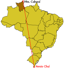
Monte Caburaí is a mountain located on the border between the South American countries of Brazil and Guyana standing at 1,465 metres (4,806 ft) above sea level. The source of the Ailã river [pt] (or Uailã river), located on the mountain, is the northernmost point of Brazil.[1]
See also
References
- ^ "Brasil em síntese - território - dados geográficos". IBGE (in Portuguese). Retrieved 2022-10-04.
- v
- t
- e
 | This Roraima, Brazil location article is a stub. You can help Wikipedia by expanding it. |
- v
- t
- e
 | This South America mountain, mountain range, or peak related article is a stub. You can help Wikipedia by expanding it. |
- v
- t
- e


