Moergestel
Village in North Brabant, Netherlands

Coat of arms
51°33′0″N 5°11′0″E / 51.55000°N 5.18333°E / 51.55000; 5.18333
(2021)[1]
5066[1]
Moergestel (Dutch pronunciation: [ˈmuːrˌɣɛstəl]) is a village in the Dutch province of North Brabant. It is located in the municipality of Oisterwijk, about 7 km East of Tilburg.
History
The village was first mentioned in 1147 as Gestele, and means "guest house". Moer (moorland / peat excavation settlement) was later added to distinguish from Luyksgestel.[3] Moergestel started on a sandy ridge near the brook Reusel. It is started to develop when the roads from Tilburg to Eindhoven and Oisterwijk to Hilvarenbeek intersected in the village.[4]
The tower of the St John, the Baptish church dates from the 16th century. Later the church was added to the tower. Between 1930 and 1931, the church was replaced.[4] The nameless grist mill of Moergestel was built in 1852. Some parts of the wind mill dates from around 1600. In 2010, it was restored and operates on a voluntary basis.[5]
Moergestel was home to 389 people in 1840.[6] Moergestel was a separate municipality until 1997, when it became part of Oisterwijk.[7]
Gallery
-
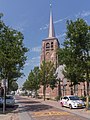 Church: de Sint Janskerk
 -
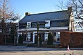 House in Moergestel
 -
 House in Moergestel
 -
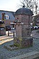 Village pump


References
- ^ a b c "Kerncijfers wijken en buurten 2021". Central Bureau of Statistics. Retrieved 18 April 2022.
three entries
- ^ "Postcodetool for 5066AA". Actueel Hoogtebestand Nederland (in Dutch). Het Waterschapshuis. Retrieved 18 April 2022.
- ^ "Moergestel". Etymologiebank (in Dutch). Retrieved 18 April 2022.
- ^ a b Chris Kolman & Ronald Stenvert (1997). Moergestel (in Dutch). Zwolle: Waanders. ISBN 90 400 9945 6. Retrieved 18 April 2022.
- ^ "(standerdmolen)". Molen database (in Dutch). Retrieved 18 April 2022.
- ^ "Moergestel". Plaatsengids (in Dutch). Retrieved 18 April 2022.
- ^ Ad van der Meer and Onno Boonstra, Repertorium van Nederlandse gemeenten, KNAW, 2011.
Authority control databases | |
|---|---|
| International |
|
| National |
|
| Geographic |
|
 | This North Brabant location article is a stub. You can help Wikipedia by expanding it. |
- v
- t
- e


